Sunday, February 27, 2022

Riding the Texas Chief, Summer 1970

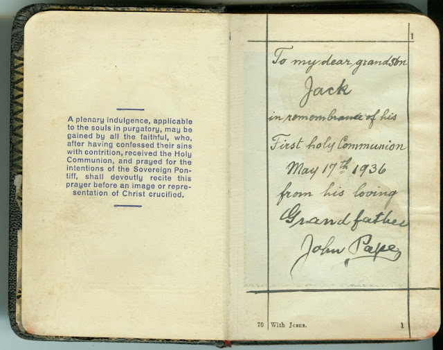
In June and July of 1970, my seven-member family of origin took the train round trip from Houston, Texas, to Chicago, Illinois, to visit my recently-widowed paternal grandmother, Elizabeth Florence Massmann Pape (1902-2000).  I'm not quite sure why we did not drive - I think it had something to do with my dad's persistent back problems (a rung broke on a ladder when he was standing on it in the 1960s) - but we did travel by automobile from Houston to Rochester, New York the following summer.  No matter the reason - it was a new experience for all of us kids.


Above:  Drumhead of AT&SF Train 15, The Texas Chief at Dearborn Station, Chicago, IL on June 13, 1968 / Roger Puta collection  / Public Domain

A drumhead is a removable sign that was common on North American railroads in the 20th century. The sign consisted of a box with internal illumination that shone through a tinted panel bearing the logo of the railroad or specific train, and 
was mounted at the rear of passenger trains.  Since the box and the sign were usually circular in shape and resembled small drums, they came to be known as drumheads.

Below:  Cover image from Texas Chief brochure/timetable, June 1, 1970


The ride from Houston to Chicago took about 26 hours.  Because of his back, Dad got a bedroom in the sleeper car, and he took Brian (who would've had the toughest time sleeping sitting up) in the room with him.  The rest of us slept (or tried to sleep) sitting up in coach.

Below is the timetable from the June 1, 1970 Texas Chief brochure:


And above is a Google Map I created with all the stops the train made.  The train first headed southwest a short distance to Rosenberg, Texas, then went northwest to Temple, Texas, then pretty much due north through Oklahoma to Newton, Kansas, then northeast from there through Missouri and the southeast corner of Iowa to Illinois and Chicago.

I don't remember much about the trip.  I'm not sure I went to the Big Dome Lounge (observation) car, nor to the dining car.  I'm pretty sure Mom packed some picnic meals for us to eat on the way, and perhaps we got drinks at the snack bar.  I do remember visiting Dad's and Brian's bedroom on the sleeper car.  I think I mostly looked out the window, following along on the timetable and the descriptions of points of interest along the way:


Above and below:  "Points of Interest along the way," from the inside and back of the Texas Chief brochure.  The descriptions are arranged going south from Chicago to Houston.


I had a Brownie camera in 1970, but I did not take any pictures while on the train.  I do remember that we were not allowed to get off the train at any stops.  The pictures below are of things and places I would have seen, many taken between 1966 and 1969.


Above:  Union Station, 501 Crawford St (HDR) [25 July 2010, cropped] / Ed Uthman / CC BY 2.0

This building now serves as the entrance to the Houston Astros baseball field, Minute Maid Park.


The train is going under US Highway 59 - see the map below - heading southward out of Houston.  You can see Union Station in the background below the elevated highway section.

Below:  Snip from 1967 United States Geological Survey 7.5 Minute Series Topographic maps of Settegast Quadrangle, Harris County, Texas, showing Union Station in Houston on Crawford Street, just northwest of Highway 59.  The black building shape at the northeast corner of Crawford and Capitol, with the pennant shape, indicates Incarnate Word Academy, and the black building shape next to that, between the Academy and Union Station, with the cross on it, is Annunciation Catholic Church.  As my aunt was principal of Incarnate Word Academy at the time we took the train to Chicago, my parents were probably able to park our car in the church/school parking lot.


Above:  This April 1950 Sanborn map shows the wooden trainshed (in yellow) for the brick Dearborn Station (in red).

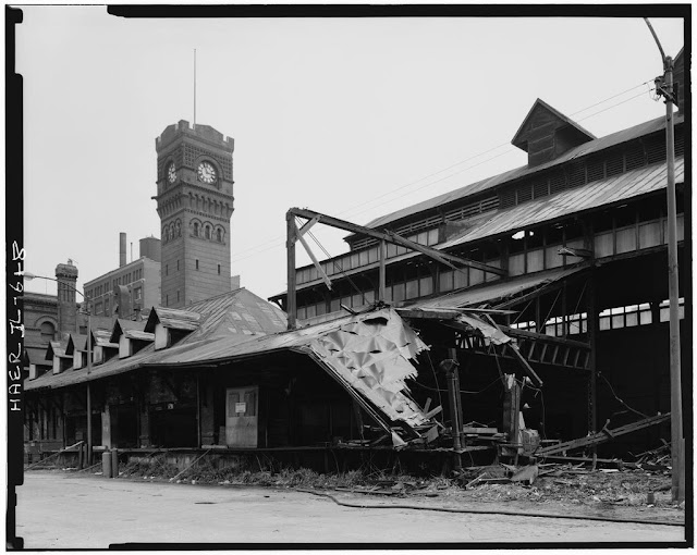
The Dearborn Station Trainshed, built in 1883-1885, was an unusual and unique example of trainshed design, combining timber and wrought iron in the massive trusses that supported the roof. It was possibly the oldest structure of its kind in the United States at the time of its destruction in May 1976.

Below:  Hedrich-Blessing. "VIEW LOOKING NORTHEAST, SHOWING TRAINSHED AT NORTH CONNECTION TO HEADHOUSE, STATION CLOCK TOWER IN BACKGROUND - Chicago & Western Indiana Railroad, Dearborn Station Trainshed, 47 West Polk Street, Chicago, Cook County, IL."  Photograph, Historic American Engineering Record, National Park Service, U.S. Department of the Interior, May 1976. From Prints and Photographs Division, Library of Congress (HAER ILL,16-CHIG,104A--8; https://www.loc.gov/pictures/resource/hhh.il0378.photos.060659p/ accessed February 27, 2022).


Below are a couple more historic images of the two train stations at the terminal points of our trip.  The Dearborn Station image is from a circa-1907 postcard.  Originally the pink granite and red pressed brick headhouse had deeply pitched roofs.  These were eliminated in rebuilding after a 1922 fire.


The image above shows Union Station in Houston, Texas, in 1911, looking as it did when my great-grandfather, Lithuanian immigrant Charles (Kazimieras) Guokas (1863-1939), first worked out of there as a fireman with the Houston & Texas Central Railroad.  Two more stories were added to the building in 1912.


© Amanda Pape - 2022 - e-mail me!

Thursday, February 17, 2022

Printer's Row, Chicago Tour with Mike on Heygo

This past Sunday, I went on a tour of the Printer's Row neighborhood in Chicago, Illinois.  Here are some photos I took on that tour:


Above and below:  Entrance to the Franklin Bulding at 720-732 S. Dearborn St.  It was designed by George Croll Nimmons for the Franklin Printing Company and built in 1916.  This east façade is decorated with polychrome terra cotta tiles.


Oskar Gross, a painter from Vienna, Austria, did a mural (above) over the main entrance entitled "The First Impression," of the printing of the first Gutenberg Bible.  He also painted panels for the building depicting an artist, engraver, typesetter, bookbinder, and other artisans involved in the printing process, which were reproduced in tile and are between the first and second floors on the east façade (below).


Above:  The Franklin Building is 14 stories tall and housed presses until 1983.  It underwent a $9 million restoration and was converted into 65 condominium loft apartments in 1989.

Below:  Painted cast iron on the adjacent Rowe Building, 714 South Dearborn Street, constructed in the 1890s.  This Chicago School commercial building with classical details now house Sandmeyer's Book Store (and you can see a book, in the window display, about Printer's Row, in the lower right corner of the photo).

Above:  The Donohue Building, 701-721 South Dearborn Street, built in the 1880s with Romanesque and Eastlake details for the M.A. Donohue & Co., publishers of children's books.  It served as headquarters until 1971, and in 1979 became the first of the city’s factory lofts to undergo conversion into a residential condominium. 

Below:  The Pontiac Building, at 542 South Dearborn Street on the corner of Harrison, was built in 1891 and the oldest surviving work in downtown Chicago designed by the architecture firm Holabird & Roche.  This 14-story building is also in Chicago School style, with classical details such as the terra cotta cornice at the top.  This building also has interesting patterns of bay windows.  It was part of the Historic American Buildings Survey in the 1930s, and was added to the National Register of Historic Places in 1976.


Above:  Lakeside Press Building, 731 South Plymouth Court, designed in the 1890s by Howard Von Doren Shaw, is one of few large buildings designed by a Prairie School architect.  It also has Craftsman and classical details.  It was also in the Historic American Buildings Survey in the 1930s.  

Below:  Image of part of the Tours With Mike page on the Heygo platform.


So how was I able to get all these great photos in Chicago this past Sunday, and for that matter go on a tour?  By participating in a FREE* Tour(s) with Mike on the Heygo platform!

*The virtual tours are done on the Heygo live-streaming platform - and it is awesome.  There is no cost to do the tours, but you are encouraged to tip to support both the guide (who gets 60%) and Heygo and its operating costs.

Mike McMinns is a Chicago resident with a background in real estate and urban planning, who started going on the Chicago Architecture Center's tours and then serving as a volunteer docent with them.  Last year, he started his own company, Tours with Mike, and now does in-person, virtual, and app-based tours full-time.  

In the past five weeks, I've been on a dozen of Mike's Chicago Heygo tours.  I did his six-part Chicago Architecture 101 series (and learned SO much), four of his "Chicago's Greatest Hits" series (which focus on the city’s most popular attractions, like Millennium Park, the Riverwalk, Navy Pier, and the Museum Campus), and two from his Chicago's Neighborhoods series - which included Printer's Row.

The tagline on Mike's website is "Making architecture & history fun & interesting!" That is exactly what he does.  He is SO personable, and clearly well-prepared for the tours.  He's very conscious of the desire of attendees to get "postcards" (what Heygo calls pictures, essentially screenshots that you take and save within the platform and can later download).  He'll get in the best locations for the best angles and turn his smartphone on the gimbal from landscape to portrait mode as needed.  All of the photos of buildings you see in this post were grabbed by me during the tour.

Mike also brings a second smartphone to use for visual aids.  Sometimes these are used for past-and-present comparisons, such as in the examples below, and sometimes to show us things inside buildings (as livestreaming a tour inside a building is often not permitted).  He'll point out particular features within the view as well.


The Mergenthaler Linotype Building, 531 South Plymouth Court, designed by Schmidt, Garden & Martin in Romanesque Revival style and built in the 1880s, before (above) and after (below) renovation into condominiums in 1980. 


The tour began at Dearborn Station, a passenger train station through 1971, renovated into commercial space in the 1980s.  It seemed vaguely familiar.  When my husband and I visited my son in Chicago in 2017, we took the train from Fort Worth, Texas, arriving at Union Station in downtown Chicago.  I didn't recognize anything there from a train trip I took with my family of origin to Chicago from Houston, Texas, in June 1970.  With further research, I realized we arrived at Dearborn Station in Chicago, not Union Station.  More about that trip in my next post.

Above:  The clock tower of the 1885 Dearborn Station, designed by Cyrus L. W. Eidlitz.  
Below:  Close-up of some Richardsonian Romanesque style features of Dearborn Station.


© Amanda Pape - 2022 - e-mail me!

Thursday, February 10, 2022

Those Places Thursday: Suitland Manor and the NIC-1, Suitland, Maryland, 1944-45

Lately I've been working on a HUGE project - sorting through at least 500 photographs (mostly snapshots) of my husband Mark, mostly from his first 15 years.  Naturally, almost none of the photos are labeled or dated.  I've been sorting them into groups based on numbers stamped on the backs of some (indicating they were processed at the same time), type of paper and processing used, and clues in the photos based on location, other people in the photo, and a guess on my husband's age at the time.

With the snowstorm we had a week ago, the only two pictures with snow caught my eye.  Mark lived most of his early life in Corpus Christi, Texas; Myrtle Grove, Florida; and Guam - but his family did spend almost two of the World War II years in the Washington, D. C. area.  His father Francis Edward Gresham (1911-1990) enlisted in the Navy on April 13, 1944, and was sent to work as a negative engraver and cameraman at the Naval Hydrographic Office in the Washington, D.C. area.  During that time, the family lived at 4613 Lewis Avenue SE, Apartment D.  Francis was released from military service in January 1946, and the family moved back to Corpus Christi. 

Here's Mark playing outside what was probably the family's apartment during the winter of 1944-45, or late in 1945.  I'm thinking it was probably the latter, as he looks more like he is age four rather than three.  This was probably the first, and perhaps the only, time that he saw snow as a child.


I tried to map 4613 Lewis Avenue SE in Washington, DC, but there was no such location.  When I tried just mapping the address in the DC area, I got a hit for an area in Suitland, Maryland - but the building was gone.

The photo of Mark below, processed in September 1945, had another building in the background that proved helpful in figuring out where this was.  Notice the thick white framing around the door of that building, and the three rows of three window panes each in the door itself.  You can see the bottom row in the photos above.


An article about Suitland at the United States Census Bureau website stated that "The Suitland Manor apartments, directly across Suitland Road from the Federal Center [where the Census Bureau is located], were built in 1942 in anticipation of an influx of federal workers.  Parkway Terrace, off Silver Hill Road at Suitland Parkway was built five years later."  Although Parkway Terrace was a bit closer to where Francis worked (more on that in a bit), it was not constructed until after the Gresham family moved back to Texas.

An article in the June 14, 1942, New York Times, section RE, page 6, called "BUILDS 650 SUITES NEAR WASHINGTON; Minskoff Will Open Suitland Manor About Aug. 1," stated that "An extensive garden apartment project by Sam Minskoff Sons, New York builders, called Suitland Manor is nearing completion in suburban Washington, on Suitland Road, Prince George's County, Md., for occupancy August 1."

Below is a photograph of the back side of a Suitland Manor four-unit apartment building.  Mark says this looks like what he remembers.

Above:  Suitland Manor 4-unit apartment building, from page 11 (image 19) of the February 2006 "Approved Suitland Mixed-Use Town Center Development Plan" by The Maryland-National Capital Park and Planning Commission, Prince George's County Planning Department, Maryland.


Over the years since World War II, the 142 four-unit two-story brick buildings of Suitland Manor deteriorated.  In 1993-1995, an effort was made to renovate five of the buildings, but they were ultimately sold to Prince George's County in 2000.  A photo from that time period was what helped me determine the Greshams lived in Suitland Manor - the door is very similar to the door in the photos with Mark, and the address number on this building is 4701, close to 4813.  A comparison of the front doors in these three photos is below.


Beginning in the early 2000s, the Redevelopment Authority of Prince George's County began acquiring properties in Suitland Manor, along Homer Avenue (now Towne Park Road), Huron Avenue, Hudson Avenue (now Towne Square Boulevard), Lewis Avenue, and Chelsea Way. The acquisition, totaling 22 acres, was complete in 2007. The tenants were relocated and all buildings were demolished (from page 6, image 9).  This area is slated for new housing and other development.

Suitland Manor was located just across the road from the Suitland Federal Center, a 437-acre parcel acquired by the federal government in 1942 for offices needed in the war effort.  Federal Office Building No. 3 (the large maroon one in the upper right corner in the 1986 map pictured below) was the first one built, and the U.S. Census Bureau was the first occupant, in spring 1942.  Suitland Road runs across the top (north side) of this map, and Silver Hill Road runs along the right (east) side of the map.  Suitland Manor was just northwest of the intersection of Suitland and Silver Hill roads.


Above:  Map of the Suitland Federal Center in 1986.  United States Bureau Of The Census. (1986) Suitland Federal Center ; Washington metropolitan area and vicinity. [Suitland, Md.?: U.S. Dept. of Commerce, Bureau of the Census] [Map] Retrieved from the Library of Congress, https://www.loc.gov/item/87693177/.

Below:  Closeup of the northeast corner of the same map pictured above.  Of the buildings pictured here, only the historic 1937 Suitland House still stands.  Other buildings have been replaced by newer ones.


So what about the NIC-1?  The Navy Hydrographic Office Building, later known as the Naval Intelligence Command Building or NIC-1, was completed in 1942. Originally it housed staff involved in underwater charting and naval aerial photography. Various Navy functions continued in the building until it was demolished in the early 1990s. The building is the pinkish one in the maps above that is on the far right, just below the large FB-3 (Federal Office Building #3), fronting on Silver Hill Road.

The building was originally a three story, flat-roofed brick building, 338 feet long, with 298-foot wings at each end.  By 1943, a two-story wing was added on the back side between the other two wings, forming an irregular E-shape viewed from above.  The building looked pretty much the same in 1944 as it did in May, 1991, when the photos below were taken (except of course for the sign above the entrance).  The building was demolished soon afterward.


Photos above (front, northwest elevation) and below (main entrance) from May 1991 by  Karen Schneebaum, from PG:75A-23: Naval Intelligance Command I (NIC), the Individual Property/District Maryland Historical Trust Internal NR [National Register of Historic Places] Eligibility Review Form.


I imagine Francis probably walked to work at the Naval Hydrographic Office (NIC-1) from his apartment home nearby at Suitland Manor.


© Amanda Pape - 2022 - e-mail me!

Wednesday, February 9, 2022

My First Communion Dress - December 6, 1964

Continuing the theme of First Communion and the exchange of posts with my reader Aleksandra, here is a close-up picture of me on my First Communion Day, December 6, 1964.  


My mother made the dress, but the veil was store-bought (and later worn by my two sisters for their First Communions).  I can see in the photo that I am holding a prayer book and a rosary, which were probably gifts, and I also appear to be wearing a necklace, probably a religious medal.  I did get a little "remembrance" pamphlet (images of it are pictured below), but I don't remember getting something really cool like a wristwatch, as Aleksandra did in Poland!


© Amanda Pape - 2022 - e-mail me!

Sunday, February 6, 2022

Jack Bleidt's First Communion, May 17, 1936

My regular blog reader Aleksandra commented on my last post, which was a photo of my dad, Frederick Henry Pape (1929-2017), on his First Communion Day.  She asked if there were any traditions regarding First Communion Day presents.  

Well, I don't know for sure what my dad got, but it was probably more or less the same as what his first cousin and classmate, John Charles "Jack" Bleidt (1928-1973), who was only nine days younger than him, got.


Above:  May 17, 1936, First Communion Day for Jack Bleidt (age 7).  He is pictured with his grandfather John Pape (1851-1945), and older sister Mary Jane Bleidt Herring (1924-1965).  Photo courtesy cousin Bill.

Below:  Jack's First Communion certificate, from St. Margaret Mary Catholic Church in Chicago, Illinois.  It is signed by its pastor and founder, Father George McCarthy.  Photo courtesy cousin Bill.


Jack received what appears to be a prayer book (it's too small to be a complete Bible) from his maternal grandfather, John Pape.  It is inscribed near the beginning as follows:  "To my dear grandson Jack in remembrance of his First holy Communion, May 17th 1936, from his loving Grandfather John Pape."  Below are some images of the first few pages of the book.


Above and below:  photos from the interior of the book given to Jack Bleidt by his grandfather John Pape for his First Communion Day, May 17, 1936.  Photos courtesy cousin Bill.


I'm pretty sure my great-grandfather John would have given my father the same thing.  Besides being first cousins, just nine days apart in age, and first-grade classmates at St. Margaret Mary Catholic School, at the time of First Communion, Jack's family was living practically across the street from Dad's in Chicago.  Based on the address Jack wrote in the book, the Bleidt family lived at 2084 [West] Lunt Avenue.  Dad and his family lived at 2093 West Lunt.  And in 1936, John Pape was living at 1949 West Lunt, just a few blocks away.


© Amanda Pape - 2022 - e-mail me!

Friday, February 4, 2022

Happy 93rd Birthday to My Dad in Heaven!


My dad, Frederick Henry Pape (1929-2017), dressed for his First Communion, probably at St. Margaret Mary Catholic Church in Chicago, Illinois, probably May 17, 1936.  The son of his first cousin Jack Bleidt (1929-1973), who was just nine days younger and was in Dad's first grade class at St. Margaret Mary Catholic School (in 1935-36), has Jack's First Communion items dated May 17, 1936 at St. Margaret Mary.  That will be the topic of a future post.


© Amanda Pape - 2022 - e-mail me!