Showing posts with label Those Places Thursday. Show all posts

Thursday, September 3, 2026

Looking for the Address of the West Town Quality Bakery in Chicago - Part 1


Recently someone posted a photo in the Forgotten Chicago Discussion Group on Facebook of the West Town Quality Bakery.  I currently don't have permission to post the photo here, so I will describe it.  There was a sign in the window indicating the proprietor was J. Klimacek, and the bakery would have its grand opening on Saturday, September 6.  An awning above the bakery window had the bakery's name and the number "1143" on each side of it.  That may (or may not) be part of the address.

The gentleman who posted the photo stated that "My grand-uncle and great-grandfather owned and operated this bakery in Chicago. We really have no memories or knowledge of where it was located exactly. Based on the name I would assume it might have been located in West Town. That side of the family is Slovak too."

In the 1930 census, I found a John Klimacek, born about 1883, a baker with his own shop, living at 1141 (S.) Western Avenue.  When I asked if that was his family, the gentleman replied, "That would be my great-grandfather most likely. His son my grand-uncle is also named John."  That matched with the other family members - son John in the family, wife Elizabeth, and five other kids, Elizabeth, Anna, Susie, Mary(an), and Steve.  

Here are the images - John and his wife at the bottom of one page, the six children on the next page.  I've also included the addresses on either side of them, and the headings and footers for the pages, as I'll be coming back to some of this additional information.  Click on the images to make them larger.


Above:  John Klimacek Sr. family on the 1930 Census.  Images from "United States, Census, 1930", FamilySearch (https://www.familysearch.org/ark:/61903/1:1:XSG8-1K2 : Fri Oct 17 07:37:54 UTC 2025), Entry for John Klimacek and Elizabeth Klimacek, 1930.


My immediate thought was that the bakery was next door at 1143 S. Western Avenue.  Often a business would be on the first floor, and the owner (or others) would live upstairs (notice the people living at 1143 in 1930 are renters).  So I decided to do some research to support that hypothesis.

But first, I needed to determine the time frame.  That involved researching the John Klimacek family, to determine when they were in Chicago.  John Sr. and John Jr. were both born in Czechoslovakia, in 1883 and 1907 respectively.  John Sr. died in Chicago in 1938 and John Jr. probably in Berwyn, Illinois, in December 1971 or January 1972.

However, if you look at the details on the children in the 1930 Census, the four middle children (all girls) were born in Pennsylvania.  The youngest child, Steve, was born in Illinois, about 1920 or 1921.

I found Steve's (Stephen's) birth certificate in FamilySearch.  He was born November 24, 1920, at 5800 S. Loomis St. (now S. Loomis Blvd.) in Chicago.


Above:  Stephen Klimacek Chicago, Illinois birth certificate, 24 November 1920.  Accessed through "Illinois, Cook County, Birth Certificates, 1871-1953", FamilySearch (https://www.familysearch.org/ark:/61903/1:1:N774-CL3 : Sat Jan 18 00:14:28 UTC 2025), Entry for Stephen Klimacek and John Klimacek.


Just a few weeks later, 14-year-old John Jr. - who for some reason had stayed behind in Czechoslovakia after his parents emigrated in 1907 (father) and 1909 (mother Alzbeta/Elizabeth) - arrived in New York City, on December 21, 1920.  His passenger list indicates he was going to join his father Jan Klimacek at 5800 Loomis Street.


Above:  Passenger list (left and right side) for Jan (John Jr.) Klimacek, entry #15, from "New York, Passenger Arrival Lists (Ellis Island), 1892-1925", FamilySearch (https://www.familysearch.org/ark:/61903/1:1:J6HF-1JH : Sat Jul 04 18:41:04 UTC 2026), Entry for Jan Klimacek and Jan Bielcik, 21 December 1920.


I couldn't find the family on the 1920 census.  They may have been in transit from Heilwood, Indiana County, Pennsylvania, where the youngest daughter Maryan was born in November 1918 (per her grandson; supported by the 1930 census and her husband's family history narrative).  They were not at 5800 Loomis in Chicago in the 1920 census, nor were they in Pennsylvania.

The next record I could find for John Sr. was an index card for his 1924 naturalization.  (The actual naturalization documents are not online.)  At that time, he was living at 1531 W. 18th Place in Chicago.  He was also at this address in the 1923 city directory, but his name was recorded as Jos (Joseph) instead of Jno (John or Jonathan), and it says he is in soft drinks.  I believe the typesetter for the directory mixed him up with various men with the last name of Klimas who were in this business and also lived on W. 18th. 


Above:  Naturalization index card for John Klimacek, from "Illinois, Northern District Naturalization Index, 1840-1950", FamilySearch (https://www.familysearch.org/ark:/61903/1:1:XKG4-D8R : Sun Mar 29 01:33:19 UTC 2026), Entry for John Klimacek, 1924.

Below:  John Klimacek in the 1923 city directory, from https://collections.newberry.org/asset-management/2KXJ8Z8MI3EDK?FR_=1&W=1920&H=1083 (4th image)


However, by the time of the 1928 Polk reverse (criss-cross) directory for Chicago, John Sr. had moved his family to the 1141 S. Western Avenue address.  John Sr. also gave this as his address when he witnessed the petitions for naturalization for Mrs. Mary Valoch (formerly Mary Klimacek, probably a relative) on February 15, 1929; for Mrs. Anna Klimacek (probably another relative) on May 7, 1929; and for Edward Valenta on March 19, 1930.

John Sr. also appears at the 1141 S. Western Avenue address in telephone directories (White Pages) in Summer 19301932, September 1933, June 1934, December 1935, September 1936, and June 1937.  Note that in all these cases, the address is listed as his residence, not as a bakery.


Above:  Klimaceks in the June 1937 Chicago White Pages telephone directory, from https://www.loc.gov/resource/gdcmassbookdig.usteledirec04783x/?sp=350&st=image&clip=3978,610,880,879&ciw=968&rot=0


In the September 1936 and June 1937 (pictured above) telephone directories (White Pages), John Jr. has a separate listing (just under his father's residential listing) - for a bakery, at 3329 W. North Avenue.  It is also listed in the Yellow Pages under Bakeries, Retail, in August 1936 (pictured below) and in August 1937.  


Above:  Klimacek bakery in the August 1936 Chicago Yellow Pages business telephone directory, from https://www.loc.gov/resource/gdcmassbookdig.usteledirec04781x/?sp=318&clip=5170,619,864,383&ciw=951&rot=0


However - all Klimacek entries disappear from both directories in 1938 and 1939.  John Sr. died on September 29, 1938.  At that point, he had been suffering from chronic myocarditis for about two years, according to the death certificate.  The certificate also indicated he had been working as a baker through January 3, 1938.  It may be that John Sr. turned over the family bakery business to John Jr. when he became ill, and perhaps the business was also relocated to 3329 W. North Avenue at that time.  


Above:  Death certificate for John Klimacek (Sr.), from "Illinois, Deaths and Stillbirths, 1916-1948", FamilySearch (https://www.familysearch.org/ark:/61903/1:1:NQB9-LX3 : Mon Jan 27 22:10:32 UTC 2025), Entry for John Klimacek and Martin Klimacek, 29 Sep 1938.


Note that John Jr. was listed as the informant, and gives his address as 3046 W. 54th Street.  That was also his address on the 1940 census (line 50, enumerated April 5) and on his World War II draft registration card (October 16, 1940).  See both below - click on all images in this post to make them larger.


Above:  John Klimacek (Jr.) on the 1940 census, line 50, from "United States, Census, 1940", FamilySearch (https://www.familysearch.org/ark:/61903/1:1:KWB9-9RH : Fri Mar 08 21:34:30 UTC 2024), Entry for Peter Valach and Anna Valach, 1940.

Below:  World War II draft registration card for John Klimacek (Jr.), from "Illinois, World War II Draft Registration Cards, 1940-1945", FamilySearch (https://www.familysearch.org/ark:/61903/1:1:QPZC-WCG7 : Tue Apr 08 02:28:00 UTC 2025), Entry for John Klimacek and Robert Vesely, 16 Oct 1940.


These two documents have some important clues.  On the census, it states John Jr. is a baker in a retail bakery - but the "PW" in the next column (#30) means he is a "wage or salary worker in private work," not an employer or working on [his] own account.  And the draft registration indicates his employer is a Robert Vesely, place of employment 748 S. Pulaski in Chicago.  Robert Vesely's 1940 census indicates he is the proprietor of a retail bakery.

So what does all this mean?  It means the West Town Quality Bakery, at an address beginning with 1143 in Chicago, had to exist sometime between November 1918 (when Maryan Klimacek was born in Heilwood, Pennsylvania) and April 1940 (when John Jr. was clearly not operating a family-owned bakery).

In Part 2, I'll show why I think 1143 S. Western Avenue was the address of the bakery in late 1930, and *possibly* at the time the photo was taken.

And an important note - when I checked all those Chicago city and telephone directories (1919 through 1939), I could not find a listing for a West Town Quality Bakery or a West Town Bakery in either the White Pages or the Yellow Pages.  No easy answer there!

Here is Part 2:  https://abt-unk.blogspot.com/2026/09/looking-for-address-of-west-town_01461349635.html


© Amanda Pape - 2026 - e-mail me!

Thursday, October 24, 2024

An Old Well on the Granbury Courthouse Square

Earlier this week, I got a sneak peek at the new location of local/my favorite restaurant, Christina's American Table, which will be on the first floor of the recently-restored historic Nutt House Hotel.  In the men's room, there is a window in the floor with a view of an old well (see the photo below).


Above:  View through a window in the floor of the men's room of the old well underneath the Nutt House Hotel and Christina's American Table.

Below:  A wider view of the men's room and the "window to the well."


Apparently, one of the stone pier-and-beam supports when this stone building was constructed (sometime between March 1893 and July 1898) was placed right over the old well opening, and the well was rediscovered in the recent renovation.  So of course I immediately wondered if the well showed up in any old Sanborn fire insurance maps.

Well, it is not specifically marked on any of the available maps.  However, I have a guess on where it was located.  First, look at this map from July 1898.  The building is on the northwest corner of the intersection of Bridge and Crockett. It first appears, in its present stone (indicated by the blue coloring) form, on the July 1898 Sanborn map. Note the location of the wooden posts down the middle of the building (where the red arrow is pointing - click on the image of the map to enlarge it).  They are still there, and this well is to the west (left on the map) of them.


Above:  excerpt of the July 1898 Sanborn fire insurance map for the building that is now the Nutt House Hotel and Christina's American Table in Granbury, Texas -  https://maps.lib.utexas.edu/maps/sanborn/g-i/txu-sanborn-granbury-1898-2.jpg

Below:  excerpt of the March 1893 Sanborn fire insurance map for the site of the building that is now the Nutt House Hotel and Christina's American Table in Granbury, Texas - https://maps.lib.utexas.edu/maps/sanborn/g-i/txu-sanborn-granbury-1893-1.jpg


The building in present form (see the photo below) was constructed sometime between March 1893 (based on the Sanborn map above) and July 1898. Its predecessor was two wood frame (indicated by the yellow coloring) buildings. Note that the one on the left does not extend as deeply into the lot as the one on the right. Although no well is indicated on this map, the well could have been there anyway and not mapped, or it could have been constructed after March 1893, and then the stone building of today built over it.


Above:  Nutt House Hotel on March 2, 2023, after the March 1, 2023 fire that nearly destroyed it when its restoration was nearly complete.

Below:  Nutt House Hotel on October 24, 2024, about to reopen, with Christina's American Table on the first floor.


© Amanda Pape - 2024 - e-mail me!

Thursday, June 27, 2024

Bridges on the Daugyvenė River, Gikoniai, Pakruojo, Šiauliai, Lithuania

According to my third cousin Osvaldas Guokas, near the Savickas windmill and the Jasilonis building (discussed in my last post) near Gikoniai (in Pakruojo, Šiauliai, Lithuania) was an old bridge across the Daugyvenė river.  Osvaldas said, 
"It is a good place for swimming and my uncle and other children from Čelkiai went here in summer time in childhood."  He found the place where the old bridge was located, on an old road from Gikoniai to Šeduva.  In the photos below, you can see where the bridge once was, with some of its stone supports in the water and the wooden supports to the side.


Above and below:  Site of the old bridge over the Daugyvenė river, south of Gikoniai, Pakruojo, Šiauliai, Lithuania.  Photos by Osvaldas Guokas, 2 June 2017.


Near the home of Steponas Radauskas (1899-1944), my first cousin twice removed, at the north end of Gikoniai, there is another bridge over the Daugyvenė river.  According to Osvaldas, it was constructed during the Soviet era.  On the other side of the river is the village of Plaučiškiai.  

The daughter of Steponas, Aldona Radauskaitė Zigmantavičienė (1934-2018), married Alfonsas Zigmantavičius (1929-2004), who was from Plaučiškiai, and after their marriage they lived in that village.  His workplace was apparently closer to the Radauskas home in Gikoniai, so Osvaldas thought he organized a group to build the bridge to shorten their commute over the old bridge.

However, Osvaldas later learned, from talking with older ladies in Plaučiškiai, that it was constructed earlier than that.  When he told the ladies his theory, they "just smiled and said, 'Oh no! He did it directly from Plaučiškiai to the Radauskas yard, for easier visits with Aldona Radauskaitė. It is a Bridge of Love!'"


Above:  bridge over the Daugyvenė river, leaving Gikoniai and heading towards Plaučiškiai in Šiauliai county, Lithuania.
Below:  map of memories of Aldona Radauskaitė Zigmantavičienė of the Gikoniai area, annotated by Osvaldas Guokas to mark the old bridge and the "Bridge of Love" over the Daugyvenė river.


© Amanda Pape - 2024 - e-mail me!

Thursday, June 22, 2023

Circa 1865 Map of Winn Parish, Louisiana

Recently I learned that Louisiana maps from the Civil War era had been digitized by the National Archives (announcement in September 2021).  These maps are described in A Guide to Civil War Maps in the National Archives on page 22 in section 1.63, "Portfolios of Captured Confederate Maps. 360 items." as "A group of manuscript parish maps received from Reese in 1866 generally showing township and private land claim lines, place names, names of landholders, roads, and routes of reconnaissances."

Here is the map from the area I am interested in, roughly the northwest third of Winn Parish, circa 1865 (click on the map to view a larger version, rotated from the one on the NARA website so north is at the top).


Above and below:  Parish maps of Louisiana captured from the Confederates ca. 1865. Winn Parish [Maps and Charts]; Records of the Office of the Chief of Engineers, Record Group 77; National Archives at College Park - Cartographic,
College Park, MD [online version available through the
National Archives Catalog (NAID: 171031960, image #4, Local ID Z33-39) at
catalog.archives.gov; June 22, 2023].  Image above has been rotated 90 degrees to the left from the original so that north is at the top.  Image below is cropped and enlarged from the image above, and the Levi Spikes land is outlined on its western half in green.


In the map above, I zoomed into a small area in the lower right of the map to be able to see the land marked as owned by "Spikes."  That would be my Louisiana great-great-great-grandfather Levi Spikes (ABT 1805 - BET 1880-1900), who patented the land in 1860.  His land was on both sides of the road, so I outlined the western portion in green (click on the map to view a larger version).

In the map below, I added an outline in blue of the land owned by my other Louisiana great-great-great-grandfather, Jacob Shelton (ABT 1822 - AFT 28 Feb 1874).  He also patented his land in 1860.  I suspect it wasn't included on the map because it was well off the main roads depicted. 


Above:  Parish maps of Louisiana captured from the Confederates ca. 1865. Winn Parish [Maps and Charts]; Records of the Office of the Chief of Engineers, Record Group 77; National Archives at College Park - Cartographic,
College Park, MD [online version available through the
National Archives Catalog (NAID: 171031960, image #4, Local ID Z33-39) at
catalog.archives.gov; June 22, 2023].  Image is cropped and enlarged from the original image at the top of this post, the Levi Spikes land is outlined on its western half in green, and the Jacob Shelton land is outlined in blue.

Below:  Capt. Chauncey B. Reese. [Between 1860 and 1870] Photograph from Civil war photographs, 1861-1865, Library of Congress, Prints and Photographs Division.  Retrieved from the Library of Congress, <www.loc.gov/item/2018669924/>.


So who is the Reese who provided the maps in this sub-collection?  The index to A Guide to Civil War Maps in the National Archives clarifies that he is the same C. B. Reese who provided other maps, and further research showed that he is Chauncey Barnes Reese (1837-1870), an 1859 graduate of West Point assigned to the United States Army Corps of Engineers.  I couldn't find any documentation as to how he acquired them, nor on who created the Winn Parish map in the first place.


© Amanda Pape - 2023 - e-mail me!

Thursday, September 29, 2022

Granbury's First Bridge

Earlier this month, I attended a presentation by some "old-timers" in Granbury (people who lived here prior to 1969, when the Brazos River was dammed to form Lake Granbury).  They shared their memories of growing up in Granbury, and some spoke about the first bridge that crossed the lake.

Thomas Ewell's 1895 Hood County History has this to say about the bridge (pages 144-145):

Not least among the great enterprises of our county is the mag­nificent tubular arch bridge, which spans the Brazos at Gran­bury, first constructed by private capital put forth in the form of a joint stock company in the year 1878, at a cost of, approximately, $25,000.  The principal men engaged in this undertaking were P. H. Thrash, the Nutt brothers, E. A. Hannaford and J. D. Baker. This bridge was originally built in three span arches, resting on four stone piers, and with its wooden approaches, had a total length of over six hundred feet.  In 1893 it was purchased by the county at $12,500, and bonds issued and negotiated for the amount.  In 1894, the river by reason of floods, so encroached upon the west side approaches, as to wash away a considerable portion, very greatly interrupting travel until the injury was repaired by the substitution of a fourth iron span upon iron pillars.  Other injuries have occurred during the year 1895, but no serious interruptions of travel, and again repairs are rendered necessary, and another iron span added. This bridge, so centrally located in our county, continued for 18 years to be the only wagon bridge across the Brazos above Waco, and has been the means of bringing thousands of immigrant wagons and travelers through our county, many of whom, pleased with its prospects, have remained to be permanent citizens.

A 1956 reprint of the book added the following information ("Hood County Today," page ii):

"The cost of the bridge was cared for by toll. ... Free traffic was opened in 1893. .... In 1932 a new bridge was built. The old bridge was torn down in 1937..."

I found an article about the bridge in the August 24, 1877, Galveston Daily News.  The article was reprinted from The Vidette, the newspaper in Granbury at that time.  This article said the bridge was four hundred feet long (which was probably the length of the iron arches):


cropped from The Galveston Daily News. (Galveston, Tex.), Vol. 36, No. 132, Ed. 1 Friday, August 24, 1877, newspaper, August 24, 1877; (https://texashistory.unt.edu/ark:/67531/metapth462488/m1/4/zoom/?q=%22tubular%20arch%20bridge%22&resolution=1&lat=806.3896458788859&lon=2854.7513022701564: accessed September 28, 2022), University of North Texas Libraries, The Portal to Texas History, https://texashistory.unt.edu; crediting Abilene Library Consortium.


An earlier reference to the contract by the Granbury Bridge Company with S. E. [sic, should be Z.] King and Company of Cleveland, Ohio, appeared in the Galveston Daily News of August 10, 1877, in a column called "Texas News By Telegraph." 


cropped from The Galveston Daily News. (Galveston, Tex.), Vol. 36, No. 120, Ed. 1 Friday, August 10, 1877, newspaper, August 10, 1877; (https://texashistory.unt.edu/ark:/67531/metapth461238/m1/1/?q=%22tubular+arch+bridge%22: accessed September 28, 2022), University of North Texas Libraries, The Portal to Texas History, https://texashistory.unt.edu; crediting Abilene Library Consortium.


Why did this transaction occur in Courtney, a town about 200 miles southeast of Granbury?  Courtney was on the Brazos River and on the railroad in the far southwestern corner of Grimes County (near today's Luther Unit of the Texas state prison).  Apparently the Granbury Bridge Company's contract was signed about the same time as that of Courtney Bridge Company, according to an article in The Daily Banner of August 11, 1877, from nearby Brenham, Texas. 

The Granbury Bridge Company representative(s) might have traveled to Courtney down the Houston and Texas Central Railroad from Fort Worth or Waxahachie (the "From Waco" portion in the 1876-1883 map below had not been - and ultimately wasn't - constructed).  Click on the map below to view a larger version; Granbury and Courtney are outlined in fuchsia.  (The Courtney Bridge was undermined by high water and collapsed in 1890.)


cropped and edited from Houston & Texas Central Railway Company. Revised map of the State of Texas., map, [1876..1883]; Chicago, Illinois. (https://texashistory.unt.edu/ark:/67531/metapth190460/m1/1/: accessed September 28, 2022), University of North Texas Libraries, The Portal to Texas History, https://texashistory.unt.edu; crediting University of Texas at Arlington Library.


So just where was this Granbury bridge located?  Its first appearance is on an 1889 U.S. Geological Survey map that was based on a survey done in 1887.  By this time, the Fort Worth and Rio Grande Railway had been extended to Granbury.


cropped from Geological Survey (U.S.). Granbury Sheet, map, 1889 [surveyed in 1887]; Reston, Virginia. (https://texashistory.unt.edu/ark:/67531/metapth451417/m1/1/: accessed September 27, 2022), University of North Texas Libraries, The Portal to Texas History, https://texashistory.unt.edu; crediting UNT Libraries Government Documents Department.


This map was the same (still using the 1887 survey) in 1949.  It clearly wasn't updated as a new bridge was built in 1932 and this one was torn down in 1937.  The bridge was gone by the 1963 map.  

The 1923 map below may be more accurate, as old-timers on the panel and another source place the bridge at the south end of Cleburne Street, on the northwest side of the Brazos River/Lake Granbury.  It joined up with Old Cleburne Road on the southeast side of the river/lake.  My house is two blocks from the north end of Cleburne Street.  I imagine remnants of the old bridge were still visible before the lake filled up.


cropped from Geological Survey (U.S.). Granbury 2-a Quadrangle, map, 1923; Reston, Virginia. (https://texashistory.unt.edu/ark:/67531/metapth455848/m1/1/: accessed September 27, 2022), University of North Texas Libraries, The Portal to Texas History, https://texashistory.unt.edu; crediting UNT Libraries Government Documents Department.


What did this bridge look like?  Unfortunately, no photographs of it survive.*  However, in 1875, the King Bridge Company had completed another tubular arch bridge (aka "King patent tubular bowstring iron bridge") for the Army at Fort Laramie, Wyoming.  It was also 400 feet long with three arches, so the Granbury bridge was probably similar to it.  Here is a photo of it in 1906 (click on the image to make it larger):


Above:  cropped from National Archives Identifier 294477; "View showing Old Fort Laramie Military Bridge across North Platte River at Fort Laramie," 1906; Photograph albums, 1903 - 1972, Volume 1; Records of the Bureau of Reclamation, Record Group 115; National Archives and Records Administration–Rocky Mountain Region (Denver).

Below:  OLD ARMY BRIDGE - FORT LARAMIE 1875 (undated / c1950), P2006-47/6, Forts & Camps - Fort Laramie #3 of 5, Wyoming State Archives.  This  copy of the image from WY-B-0008, WaterArchives.org / CC BY-SA 2.0


The surface of the Granbury Bridge probably looked a lot like this undated photo of the Fort Laramie Bridge, taken sometime before the bridge's renovation, completed in April 1969, into a footbridge.  This bridge still stands and is part of Fort Laramie National Historic Site.


Above:  undated image (taken before April 1969) of the Fort Laramie Bridge, courtesy Fort Laramie National Historic Site.  Found on page 40 of Images of America: Fort Laramie by Stanley Talbott, 2010, Arcadia Publishing.


*ETA March 32, 2024 - I was recently contacted by Melinda Jo Ray, local historian and author of the recently-published Images of America: Granbury and Hood County (Arcadia Publishing, 2024).  She kindly provided the following photographs of the 1878 Granbury bridge, which are courtesy of the Hood County Historical and Genealogical Society.  In her accompanying text, Ray noted that the bridge "was wide enough for two wagons or carriages to pass each other with ease," and that after its demolition, "its limestone pillars are still there, under the waters of Lake Granbury."


Below:  Cleburne Road Bridge, Granbury, Texas, 1902 photo by R. G.  (Dick) Kerr.


Above:  Mr. Brister in carriage on First Bridge over Brazos in Granbury, Texas.

Below:  The First Bridge - Automobiles Cross the Brazos in Granbury, Texas.


© Amanda Pape - 2022 - e-mail me!

Thursday, June 30, 2022

Levi Marion Shelton's Land in Winn Parish, Louisiana - 1903

My last two posts have been about the location of the land belonging to my great-great-great grandfathers, Jacob Shelton (317.92 acres) and Levi Spikes (79.14 acres).  Both were in Winn Parish, Louisiana, by 1860.  Today I'm writing about the land of my great-great-grandfather, Levi Marion Shelton (1863-1941), Jacob's son, who married Levi's daughter Sarah Ann Spikes in 1884.

The process was the same as in the last two posts.  First I used the United States Department of the Interior's Bureau of Land Management (BLM), General Land Office (GLO) Records Automation web site to find the location of Levi Marion Shelton's 1903 patent lands.  On the patent details page, you could scroll down and use a mapping tool (checking the box in the Map column) to see just where Levi Marion Shelton's 157.11 acres were located (click on the image to view it larger):


I went to the State of Louisiana's Division of Administration  Office of State Lands GIS & Data web page, and used the SONRIS Interactive Map linked there, choosing "Maps Historic 62.5k" as my background Imagery and using the Draw tool in the AOI Toolbox to draw lines on the map to roughly outline Levi Marion Shelton's patent.  The result is the lighter green area below (click on the image to view it larger):


The background map, as discovered in my previous posts by exploring the United States Geological Survey's Historical Topographic Map Collection using a tool called topoView, was the 1950 Winnfield, Louisiana topo map, with a scale of 1:62500.

I grabbed a screenshot of the satellite image of this area from Google Maps, and used Microsoft Paint to outline Levi Marion Shelton's land.  The result is below (click on the image to view it larger):


I found a final proof notice on page 5 of the November 22, 1901 issue of The Southern Sentinel (Winnfield, Louisiana), indicating Levi M. Shelton's intention to support his homestead claim on this piece of property.  His witnesses includes L. E. (Levi) Drewett, who owned adjacent land; W. D. Drewett, who might be William Drewett, his nephew; and James Philan and Joab L. Durham, relatives by marriage.  


On the oldest map I've been able to find (so far), the United States Department of Agriculture Bureau of Soils 1907 Winn Parish Soil Map, digitized by the University of Alabama,  I zoomed in to the appropriate sections, grabbed a screenshot, and used Microsoft Paint to outline Levi M. Shelton's land, as well as that of his father Jacob Shelton and his father-in-law Levi Spikes.  The result is below (click on the image to view it larger):


There are a couple small black squares (which mark buildings, such as houses) on the west side of Levi M. Shelton's property.  Those were apparently gone by 1950.  Levi Marion Shelton and his family had moved to adjacent Grant Parish by the time of the 1920 Census.

I also mapped the properties on the 2020 Atlanta, Louisiana topographic map, with a scale of 1:24000, to see roads and features as they appear in more modern time.  The result is below (click on the image to view it larger):


© Amanda Pape - 2022 - e-mail me!

Thursday, February 17, 2022

Printer's Row, Chicago Tour with Mike on Heygo

This past Sunday, I went on a tour of the Printer's Row neighborhood in Chicago, Illinois.  Here are some photos I took on that tour:


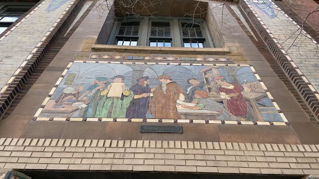
Above and below:  Entrance to the Franklin Bulding at 720-732 S. Dearborn St.  It was designed by George Croll Nimmons for the Franklin Printing Company and built in 1916.  This east façade is decorated with polychrome terra cotta tiles.


Oskar Gross, a painter from Vienna, Austria, did a mural (above) over the main entrance entitled "The First Impression," of the printing of the first Gutenberg Bible.  He also painted panels for the building depicting an artist, engraver, typesetter, bookbinder, and other artisans involved in the printing process, which were reproduced in tile and are between the first and second floors on the east façade (below).


Above:  The Franklin Building is 14 stories tall and housed presses until 1983.  It underwent a $9 million restoration and was converted into 65 condominium loft apartments in 1989.

Below:  Painted cast iron on the adjacent Rowe Building, 714 South Dearborn Street, constructed in the 1890s.  This Chicago School commercial building with classical details now house Sandmeyer's Book Store (and you can see a book, in the window display, about Printer's Row, in the lower right corner of the photo).

Above:  The Donohue Building, 701-721 South Dearborn Street, built in the 1880s with Romanesque and Eastlake details for the M.A. Donohue & Co., publishers of children's books.  It served as headquarters until 1971, and in 1979 became the first of the city’s factory lofts to undergo conversion into a residential condominium. 

Below:  The Pontiac Building, at 542 South Dearborn Street on the corner of Harrison, was built in 1891 and the oldest surviving work in downtown Chicago designed by the architecture firm Holabird & Roche.  This 14-story building is also in Chicago School style, with classical details such as the terra cotta cornice at the top.  This building also has interesting patterns of bay windows.  It was part of the Historic American Buildings Survey in the 1930s, and was added to the National Register of Historic Places in 1976.


Above:  Lakeside Press Building, 731 South Plymouth Court, designed in the 1890s by Howard Von Doren Shaw, is one of few large buildings designed by a Prairie School architect.  It also has Craftsman and classical details.  It was also in the Historic American Buildings Survey in the 1930s.  

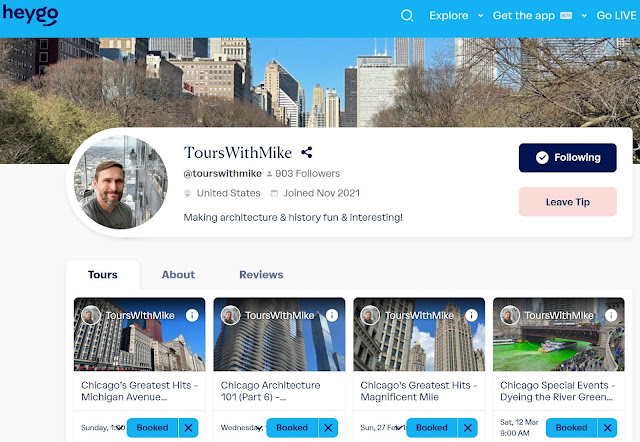
Below:  Image of part of the Tours With Mike page on the Heygo platform.


So how was I able to get all these great photos in Chicago this past Sunday, and for that matter go on a tour?  By participating in a FREE* Tour(s) with Mike on the Heygo platform!

*The virtual tours are done on the Heygo live-streaming platform - and it is awesome.  There is no cost to do the tours, but you are encouraged to tip to support both the guide (who gets 60%) and Heygo and its operating costs.

Mike McMinns is a Chicago resident with a background in real estate and urban planning, who started going on the Chicago Architecture Center's tours and then serving as a volunteer docent with them.  Last year, he started his own company, Tours with Mike, and now does in-person, virtual, and app-based tours full-time.  

In the past five weeks, I've been on a dozen of Mike's Chicago Heygo tours.  I did his six-part Chicago Architecture 101 series (and learned SO much), four of his "Chicago's Greatest Hits" series (which focus on the city’s most popular attractions, like Millennium Park, the Riverwalk, Navy Pier, and the Museum Campus), and two from his Chicago's Neighborhoods series - which included Printer's Row.

The tagline on Mike's website is "Making architecture & history fun & interesting!" That is exactly what he does.  He is SO personable, and clearly well-prepared for the tours.  He's very conscious of the desire of attendees to get "postcards" (what Heygo calls pictures, essentially screenshots that you take and save within the platform and can later download).  He'll get in the best locations for the best angles and turn his smartphone on the gimbal from landscape to portrait mode as needed.  All of the photos of buildings you see in this post were grabbed by me during the tour.

Mike also brings a second smartphone to use for visual aids.  Sometimes these are used for past-and-present comparisons, such as in the examples below, and sometimes to show us things inside buildings (as livestreaming a tour inside a building is often not permitted).  He'll point out particular features within the view as well.


The Mergenthaler Linotype Building, 531 South Plymouth Court, designed by Schmidt, Garden & Martin in Romanesque Revival style and built in the 1880s, before (above) and after (below) renovation into condominiums in 1980. 


The tour began at Dearborn Station, a passenger train station through 1971, renovated into commercial space in the 1980s.  It seemed vaguely familiar.  When my husband and I visited my son in Chicago in 2017, we took the train from Fort Worth, Texas, arriving at Union Station in downtown Chicago.  I didn't recognize anything there from a train trip I took with my family of origin to Chicago from Houston, Texas, in June 1970.  With further research, I realized we arrived at Dearborn Station in Chicago, not Union Station.  More about that trip in my next post.

Above:  The clock tower of the 1885 Dearborn Station, designed by Cyrus L. W. Eidlitz.  
Below:  Close-up of some Richardsonian Romanesque style features of Dearborn Station.


© Amanda Pape - 2022 - e-mail me!