Showing posts with label Granbury. Show all posts

Monday, March 3, 2025

Old Hood County, Texas Records

My high school boyfriend is a landman, and he contacted me last week trying to locate a particular type of land-related record for my county of residence that could help him in a recent project he was assigned.  He was looking for what is sometimes called "Assessor's Abstracts of Land," and everyone he talked to in the Hood County Clerk's office and county Tax Assessor-Collector's office either had no idea of what he was talking about, or no idea where such records - going back to the establishment of the county (in November 1866, from portions of adjacent Johnson County) - were.  Other counties my landman friend had worked with typically had the records he was looking for in one of those two offices.

I used to manage the Regional Historical Resource Depository (RHRD) at Tarleton State University, and have some familiarity with records in old bindings like the ones pictured below.  I hadn't seen the type of record my friend was looking for among our holdings (counties decide which records, if any, they want the depositories to store), but I had a feeling that if they existed, they'd either be at the RHRD for Hood County (which is University of Texas at Arlington, which doesn't even have a listing online of what their holdings are), OR they'd be at the Hood County Genealogical / Historical Society.


Above and below:  The first and second shelves of volumes of Hood County Assessor's Abstracts of Land at the Hood County Genealogical / Historical Society headquarters at the Granbury Depot.


The local story goes that somewhere back in time - the late 1970s, I think - these old records were being thrown out at the courthouse.  Local people interested in genealogy and history rescued the volumes and papers from the dumpster, and in 1983, the local society was granted a lease of the old Granbury train depot, which is where the records are stored and are available for use most Monday, Wednesday, Friday, and Saturday afternoons.  That's where I went today.


Above:  The last four of the 25 volumes of the Hood County Assessor's Abstracts of Land at the Hood County Genealogical / Historical Society headquarters at the Granbury Depot.

Below:  Sample page from the first volume of the Hood County Assessor's Abstracts of Land at the Hood County Genealogical / Historical Society headquarters at the Granbury Depot.


I wasn't quite sure if I had the right records, so I took the photo just above and sent it to my friend, who verified I'd found them.  I then photographed all the records he needed from 1880 through 1972.

According to page 42 of Inventory of county records, Hood County Courthouse, Granbury, Texas, published in 1974, here is a description of these records:

"ASSESSOR'S ABSTRACTS OF LAND. 1880-current.  29 vols., 18" x 12" x 3".
Register of assessor's abstract of surveys showing abstract number; county; number of land certificate or land patent issued; class, character, and acreage of land; to whom issued; year rendered; by whom rendered; and value. Arranged by section number, thereunder by block number, and thereunder by year.  SPF-handwritten.   Not indexed."

To "render" property for taxation means to list it with the tax assessor-collector of the taxing district in question. The "by whom rendered" is generally the property owner.  SPF is an abbreviation for standard printed form - counties could purchase blank volumes with the appropriate headings for this type of record.  The standard printed forms have been filled out by hand as opposed to typewritten.

These types of records can help a landman run title in reverse (the chain of ownership) on a particular piece of property.


© Amanda Pape - 2025 - e-mail me!

Thursday, October 24, 2024

An Old Well on the Granbury Courthouse Square

Earlier this week, I got a sneak peek at the new location of local/my favorite restaurant, Christina's American Table, which will be on the first floor of the recently-restored historic Nutt House Hotel.  In the men's room, there is a window in the floor with a view of an old well (see the photo below).


Above:  View through a window in the floor of the men's room of the old well underneath the Nutt House Hotel and Christina's American Table.

Below:  A wider view of the men's room and the "window to the well."


Apparently, one of the stone pier-and-beam supports when this stone building was constructed (sometime between March 1893 and July 1898) was placed right over the old well opening, and the well was rediscovered in the recent renovation.  So of course I immediately wondered if the well showed up in any old Sanborn fire insurance maps.

Well, it is not specifically marked on any of the available maps.  However, I have a guess on where it was located.  First, look at this map from July 1898.  The building is on the northwest corner of the intersection of Bridge and Crockett. It first appears, in its present stone (indicated by the blue coloring) form, on the July 1898 Sanborn map. Note the location of the wooden posts down the middle of the building (where the red arrow is pointing - click on the image of the map to enlarge it).  They are still there, and this well is to the west (left on the map) of them.


Above:  excerpt of the July 1898 Sanborn fire insurance map for the building that is now the Nutt House Hotel and Christina's American Table in Granbury, Texas -  https://maps.lib.utexas.edu/maps/sanborn/g-i/txu-sanborn-granbury-1898-2.jpg

Below:  excerpt of the March 1893 Sanborn fire insurance map for the site of the building that is now the Nutt House Hotel and Christina's American Table in Granbury, Texas - https://maps.lib.utexas.edu/maps/sanborn/g-i/txu-sanborn-granbury-1893-1.jpg


The building in present form (see the photo below) was constructed sometime between March 1893 (based on the Sanborn map above) and July 1898. Its predecessor was two wood frame (indicated by the yellow coloring) buildings. Note that the one on the left does not extend as deeply into the lot as the one on the right. Although no well is indicated on this map, the well could have been there anyway and not mapped, or it could have been constructed after March 1893, and then the stone building of today built over it.


Above:  Nutt House Hotel on March 2, 2023, after the March 1, 2023 fire that nearly destroyed it when its restoration was nearly complete.

Below:  Nutt House Hotel on October 24, 2024, about to reopen, with Christina's American Table on the first floor.


© Amanda Pape - 2024 - e-mail me!

Thursday, September 29, 2022

Granbury's First Bridge

Earlier this month, I attended a presentation by some "old-timers" in Granbury (people who lived here prior to 1969, when the Brazos River was dammed to form Lake Granbury).  They shared their memories of growing up in Granbury, and some spoke about the first bridge that crossed the lake.

Thomas Ewell's 1895 Hood County History has this to say about the bridge (pages 144-145):

Not least among the great enterprises of our county is the mag­nificent tubular arch bridge, which spans the Brazos at Gran­bury, first constructed by private capital put forth in the form of a joint stock company in the year 1878, at a cost of, approximately, $25,000.  The principal men engaged in this undertaking were P. H. Thrash, the Nutt brothers, E. A. Hannaford and J. D. Baker. This bridge was originally built in three span arches, resting on four stone piers, and with its wooden approaches, had a total length of over six hundred feet.  In 1893 it was purchased by the county at $12,500, and bonds issued and negotiated for the amount.  In 1894, the river by reason of floods, so encroached upon the west side approaches, as to wash away a considerable portion, very greatly interrupting travel until the injury was repaired by the substitution of a fourth iron span upon iron pillars.  Other injuries have occurred during the year 1895, but no serious interruptions of travel, and again repairs are rendered necessary, and another iron span added. This bridge, so centrally located in our county, continued for 18 years to be the only wagon bridge across the Brazos above Waco, and has been the means of bringing thousands of immigrant wagons and travelers through our county, many of whom, pleased with its prospects, have remained to be permanent citizens.

A 1956 reprint of the book added the following information ("Hood County Today," page ii):

"The cost of the bridge was cared for by toll. ... Free traffic was opened in 1893. .... In 1932 a new bridge was built. The old bridge was torn down in 1937..."

I found an article about the bridge in the August 24, 1877, Galveston Daily News.  The article was reprinted from The Vidette, the newspaper in Granbury at that time.  This article said the bridge was four hundred feet long (which was probably the length of the iron arches):


cropped from The Galveston Daily News. (Galveston, Tex.), Vol. 36, No. 132, Ed. 1 Friday, August 24, 1877, newspaper, August 24, 1877; (https://texashistory.unt.edu/ark:/67531/metapth462488/m1/4/zoom/?q=%22tubular%20arch%20bridge%22&resolution=1&lat=806.3896458788859&lon=2854.7513022701564: accessed September 28, 2022), University of North Texas Libraries, The Portal to Texas History, https://texashistory.unt.edu; crediting Abilene Library Consortium.


An earlier reference to the contract by the Granbury Bridge Company with S. E. [sic, should be Z.] King and Company of Cleveland, Ohio, appeared in the Galveston Daily News of August 10, 1877, in a column called "Texas News By Telegraph." 


cropped from The Galveston Daily News. (Galveston, Tex.), Vol. 36, No. 120, Ed. 1 Friday, August 10, 1877, newspaper, August 10, 1877; (https://texashistory.unt.edu/ark:/67531/metapth461238/m1/1/?q=%22tubular+arch+bridge%22: accessed September 28, 2022), University of North Texas Libraries, The Portal to Texas History, https://texashistory.unt.edu; crediting Abilene Library Consortium.


Why did this transaction occur in Courtney, a town about 200 miles southeast of Granbury?  Courtney was on the Brazos River and on the railroad in the far southwestern corner of Grimes County (near today's Luther Unit of the Texas state prison).  Apparently the Granbury Bridge Company's contract was signed about the same time as that of Courtney Bridge Company, according to an article in The Daily Banner of August 11, 1877, from nearby Brenham, Texas. 

The Granbury Bridge Company representative(s) might have traveled to Courtney down the Houston and Texas Central Railroad from Fort Worth or Waxahachie (the "From Waco" portion in the 1876-1883 map below had not been - and ultimately wasn't - constructed).  Click on the map below to view a larger version; Granbury and Courtney are outlined in fuchsia.  (The Courtney Bridge was undermined by high water and collapsed in 1890.)


cropped and edited from Houston & Texas Central Railway Company. Revised map of the State of Texas., map, [1876..1883]; Chicago, Illinois. (https://texashistory.unt.edu/ark:/67531/metapth190460/m1/1/: accessed September 28, 2022), University of North Texas Libraries, The Portal to Texas History, https://texashistory.unt.edu; crediting University of Texas at Arlington Library.


So just where was this Granbury bridge located?  Its first appearance is on an 1889 U.S. Geological Survey map that was based on a survey done in 1887.  By this time, the Fort Worth and Rio Grande Railway had been extended to Granbury.


cropped from Geological Survey (U.S.). Granbury Sheet, map, 1889 [surveyed in 1887]; Reston, Virginia. (https://texashistory.unt.edu/ark:/67531/metapth451417/m1/1/: accessed September 27, 2022), University of North Texas Libraries, The Portal to Texas History, https://texashistory.unt.edu; crediting UNT Libraries Government Documents Department.


This map was the same (still using the 1887 survey) in 1949.  It clearly wasn't updated as a new bridge was built in 1932 and this one was torn down in 1937.  The bridge was gone by the 1963 map.  

The 1923 map below may be more accurate, as old-timers on the panel and another source place the bridge at the south end of Cleburne Street, on the northwest side of the Brazos River/Lake Granbury.  It joined up with Old Cleburne Road on the southeast side of the river/lake.  My house is two blocks from the north end of Cleburne Street.  I imagine remnants of the old bridge were still visible before the lake filled up.


cropped from Geological Survey (U.S.). Granbury 2-a Quadrangle, map, 1923; Reston, Virginia. (https://texashistory.unt.edu/ark:/67531/metapth455848/m1/1/: accessed September 27, 2022), University of North Texas Libraries, The Portal to Texas History, https://texashistory.unt.edu; crediting UNT Libraries Government Documents Department.


What did this bridge look like?  Unfortunately, no photographs of it survive.*  However, in 1875, the King Bridge Company had completed another tubular arch bridge (aka "King patent tubular bowstring iron bridge") for the Army at Fort Laramie, Wyoming.  It was also 400 feet long with three arches, so the Granbury bridge was probably similar to it.  Here is a photo of it in 1906 (click on the image to make it larger):


Above:  cropped from National Archives Identifier 294477; "View showing Old Fort Laramie Military Bridge across North Platte River at Fort Laramie," 1906; Photograph albums, 1903 - 1972, Volume 1; Records of the Bureau of Reclamation, Record Group 115; National Archives and Records Administration–Rocky Mountain Region (Denver).

Below:  OLD ARMY BRIDGE - FORT LARAMIE 1875 (undated / c1950), P2006-47/6, Forts & Camps - Fort Laramie #3 of 5, Wyoming State Archives.  This  copy of the image from WY-B-0008, WaterArchives.org / CC BY-SA 2.0


The surface of the Granbury Bridge probably looked a lot like this undated photo of the Fort Laramie Bridge, taken sometime before the bridge's renovation, completed in April 1969, into a footbridge.  This bridge still stands and is part of Fort Laramie National Historic Site.


Above:  undated image (taken before April 1969) of the Fort Laramie Bridge, courtesy Fort Laramie National Historic Site.  Found on page 40 of Images of America: Fort Laramie by Stanley Talbott, 2010, Arcadia Publishing.


*ETA March 32, 2024 - I was recently contacted by Melinda Jo Ray, local historian and author of the recently-published Images of America: Granbury and Hood County (Arcadia Publishing, 2024).  She kindly provided the following photographs of the 1878 Granbury bridge, which are courtesy of the Hood County Historical and Genealogical Society.  In her accompanying text, Ray noted that the bridge "was wide enough for two wagons or carriages to pass each other with ease," and that after its demolition, "its limestone pillars are still there, under the waters of Lake Granbury."


Below:  Cleburne Road Bridge, Granbury, Texas, 1902 photo by R. G.  (Dick) Kerr.


Above:  Mr. Brister in carriage on First Bridge over Brazos in Granbury, Texas.

Below:  The First Bridge - Automobiles Cross the Brazos in Granbury, Texas.


© Amanda Pape - 2022 - e-mail me!

Monday, July 18, 2022

Alonzo Peyton Gordon House in Granbury

This past Saturday, I went to a presentation by the Bridge Street History Center about Alonzo Peyton (A. P.) Gordon (1847-1921), an early settler here in Granbury, and his 1882 house, which is one block south of the History Center (itself in the 1879 D. L. Nutt - Watkins House).  

Both of these places are just a couple blocks from my home.  The Gordon House is now part of the Dora Lee Langdon Cultural Center, which includes all the buildings and grounds on the entire block, and is owned and operated by the City of Granbury.

Here's how the Gordon House looked in December 2021:


Above:  A. P. Gordon House, Granbury, Texas, 22 December 2021 / Amanda Pape 


The presentation included a handout with an old photograph of the house dated 1924.  I don't have access to a good copy of that image, but the one above is similar.  The presenter remarked that "some of our preserved houses sure don't look like they used to!"

That got me wondering what Sanborn fire insurance maps might tell us about the changing footprint of the house.  Here's the house on the March 1893 Sanborn map, on the corner of Brazos and Pearl streets:


Above:  Granbury 1893 Sheet 2 (cropped).  Below:  Granbury 1898 Sheet 1 (cropped).  Both from the Perry-Castañeda Library Map Collection,
Sanborn Fire Insurance Maps - Texas (1877-1922), University of Texas at Austin.


The March 1893 Sanborn map doesn't make it very clear if the front porch (on the Pearl street side) is one story or two, but the July 1898 map (just above) does - it's two stories.

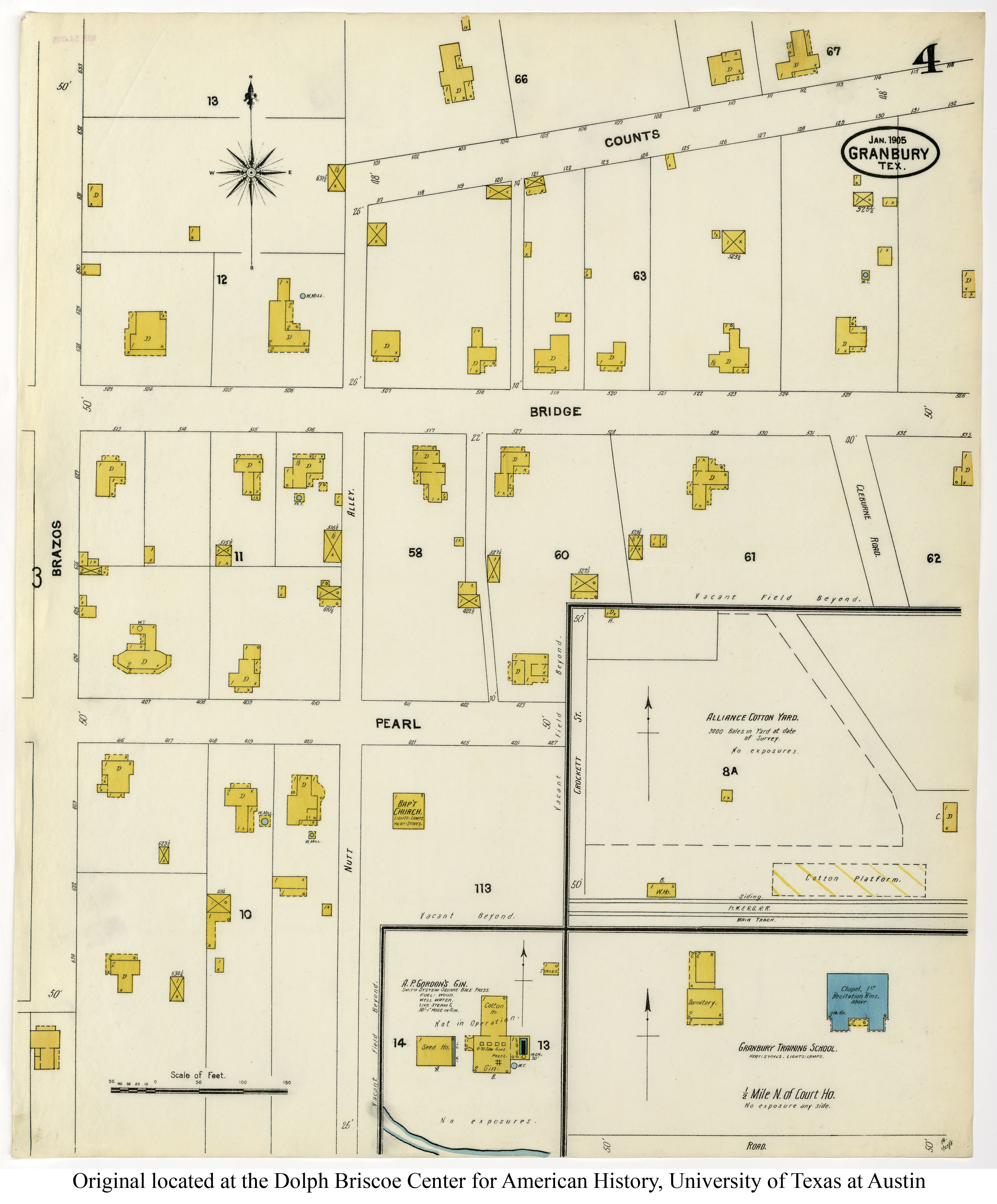
By the time the January 1905 Sanborn map was made, the front porch had been extended to wrap around the front and sides of the house, as shown below:


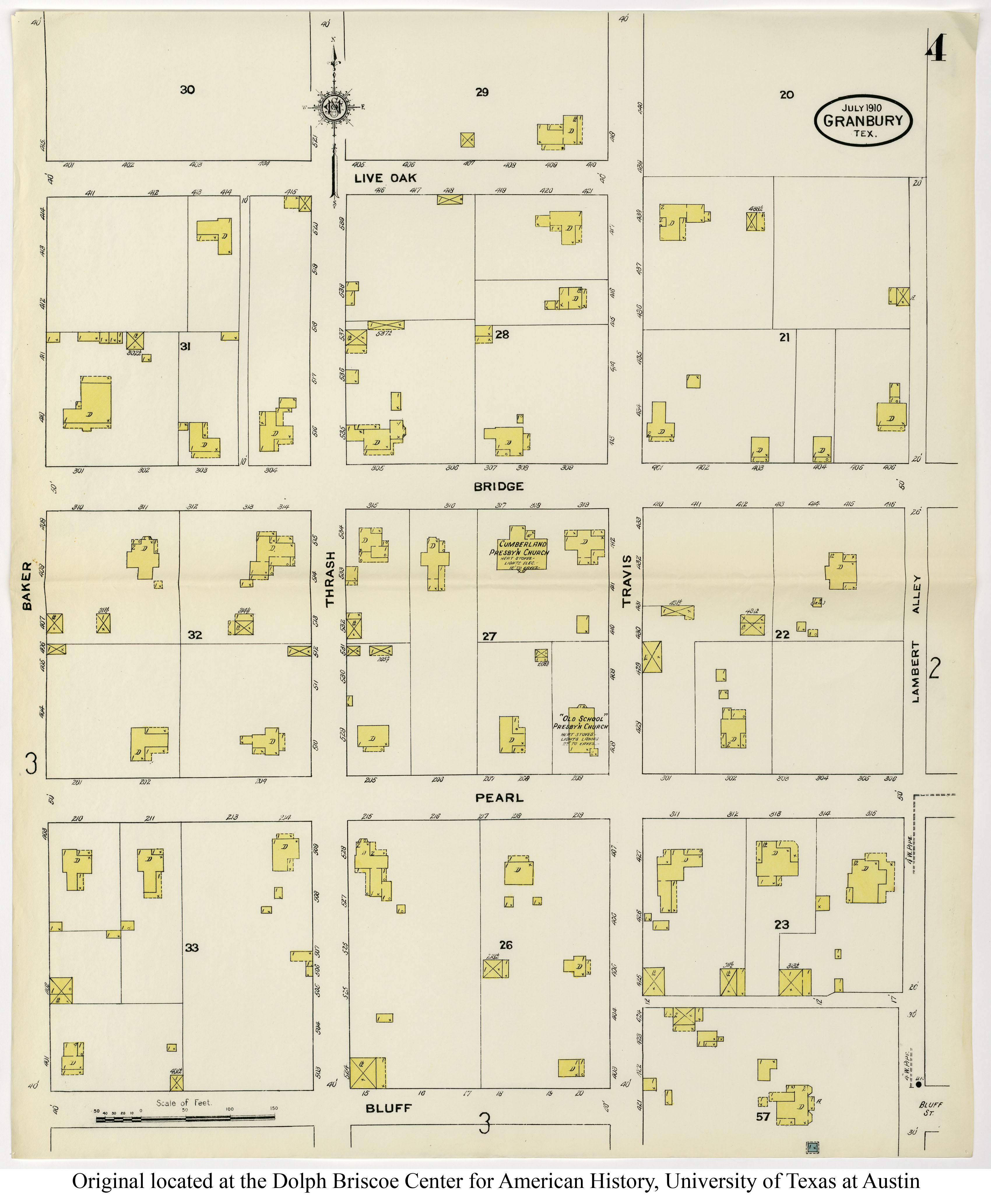
Above:  Granbury 1905 Sheet 4 (cropped).  Below:  Granbury 1910 Sheet 5 (cropped).  
Sanborn Fire Insurance Maps - Texas (1877-1922), University of Texas at Austin


By the time of the July 1910 Sanborn map (above), the two-story porch had been extended around almost the entire house.  The back wing that had the water tank had been removed, but the rest of that back wing had been extended to two stories.

The March 1945 Sanborn map (from the TexShare Proquest Digital Sanborn Maps, 1867–1970 database) shows the same configuration for the house.  In the article "Chrysalis Rings New Theme in Old House" by Ardyce Pfanstiel in the March/April 1984 issue of granbury! The Journal of the Historic Brazos River Valley (volume 1, number 2, pages 26-28), I learned that the two-story porch was removed in 1956, as was the rear two-story wing, and the existing one-story kitchen addition was constructed.

So based on all this information, the old photograph near the beginning of this post would have been dated after July 1898 (the last Sanborn map that shows only a smaller two-story front porch).

However, I would date the photograph below (also undated) as falling sometime between July 1898 and January 1905 (the first Sanborn to show a two-story front porch wrapping around the front and sides of the building.

Why?  Notice in the photograph below, you can see the projecting bay windows on the lower floor (as in the December 2021 picture at the beginning of this post).  Those bay windows do not appear on the July 1898 Sanborn.


Below:  Combination of Granbury 1905 Sheet 3 (cropped) and Granbury 1905 Sheet 4 (cropped).  Both from the Perry-Castañeda Library Map Collection,
Sanborn Fire Insurance Maps - Texas (1877-1922), University of Texas at Austin
Click on the image to make it larger.


Speaking of the bay windows, a descendant of Alonzo P. Gordon who was at the presentation told us a story about Alonzo, who owned a store on the square on the southwest corner of the intersection of Pearl and Crockett.  He said Alonzo used to walk home for his midday meal, and ate it sitting in one of the bay windows.  From there, he could see if someone entered his store, and then hurry down the street to help the customer.

The 1905 Sanborn map above shows the sight line from the westernmost bay window (hidden under the two-story porch) to Gordon's store on the corner.  I stepped into that window area while at the house, and sure enough, I could still see the building (formerly the Nutshell Bakery, now the Square Cafe, and St. Helens).


© Amanda Pape - 2022 - e-mail me!

Sunday, November 29, 2020

Historic Preservation?

I was shocked to walk by this historic house at 501 Counts Alley, which is just a few blocks from my home in Granbury, Texas, and see this today:


This is what the house looked like about a year ago:


The stone arches on the front porch are being demolished.  So far, this whimsical flower is still there, but I have to wonder - for how long?


There's also a diamond and a dragonfly (I think) in the stonework on the chimney on the west side of the house.


I decided to do a little research on this house.  The property it is on was purchased by William "Bill" Harrison Kinson, 1889-1966, and his wife Bessie Drucilla Nash Kinson, 1897-1982, on December 27, 1933.  Bill and Bessie had married in Hood County seven years earlier, on December 28, 1926.  On the 1930 Census, she was a public schoolteacher and he was a trucker, and they were renting a house on nearby Pearl Street.  They had no children.

They may have bought the house for more space.  Sometime after March 29, 1932, the Kinsons took in the three children of Grover Cleveland Oxford (1894-1960) and Maude Ann Davis Oxford (1898-1932).  Maude had died from breast and liver cancer, leaving three young children ages 2-5, Grovina, Bonita, and Derl, and the Kinsons took them in and raised them (according to Grovina's 2015 obituary).  They don't seem to be related, and it's not clear why their father did not want to raise them.  The children are listed as "lodgers" in the Kinson home on the 1940 Census.

Tax records for the house indicate it was built in 1935.  That is likely when the mixed stone exterior walls with beaded mortar were built, as the initials in the front gable, "WK," are those of William Kinson.  The Kinsons owned the home through Bessie's death in December 1982.  Earlier that year, she conveyed the house to her former lodger, Derl Crites Oxford (1930-1989), retaining a life estate for herself.  Derl lived there until his death, and the home passed out of Kinson and Oxford ownership when it was sold by Grovina in the settlement of Derl's estate in March 1991.

However, it looks like a structure very similar to the existing house has been on the site since at least January 1905, based on Sanborn maps.  In the next two images, from January 1905 and July 1910, it is the smaller house on the left, with a (then-) house number of 110.  The yellow coloring indicates that it is a wood frame structure.


Now look at the next two images, from the February 1932 and March 1945 Sanborn maps.  The 1945 map notes the stone, and you can also see a small outbuilding has been added, probably what now appears to be storage but was likely the original garage.  It's possible the stone outer wall was added over existing wood frame and siding.

Above:  February 1932.  Below:  March 1945.


This house, described as a High Style Tudor Revival, is a high priority for preservation according to a historic properties survey done by the city in 2001.  It "contributes significantly to local history or broader historical patterns; is an outstanding or unique example of architecture, engineering or crafted design; and retains a significant portion of its original character and architectural integrity."

However, a large part of that uniqueness, character, and integrity is being destroyed.  The house is not in the city's historic preservation district (HPO), so the current owners (who bought the house in January of this year) did not have to submit their plans for the exterior to the Historic Preservation Commission (on which I serve, since February 2020) for approval.

ETA 14 January 2021:  The front door that is parallel to the street has been bricked in (with similar stone), and the planter box in front of the window to the left of the porch has also been demolished.


Also, a discussion with a lifetime Granbury resident and some additional research in old newspapers revealed that Bill Kinson was elected alderman (a City Councilperson) in Granbury in April 1939.  Also, his 1966 obituary stated that the Kinsons had owned the Corner Cafe since 1958.  The Corner Cafe was in the building pictured below, at the northwest corner of Pearl and Houston streets on the Hood County Courthouse square.


Based on an early (but undated) photo of this building, it did not always have the crazy-quilt-pattern mixed stone exterior.  I have to wonder if Kinson added this as well.


© Amanda Pape - 2020 - e-mail me!

Wednesday, December 23, 2015

Advent Calendar of Christmas Memories - The Meaning of Christmas

It's the annual Advent Calendar of Christmas Memories!  I've participated the past six years (2009 through 2014), and this year, the prompts and their sequence are the same as the last two years.  Due to some pressing needs to get some other projects done (like gift books for my parents made out of the previous years' blog posts), I'm going to link to the appropriate post from 2014 (which also links to older posts, when applicable) in the prompt title, and add a relevant photo.


The prompt for December 23 – The Meaning of Christmas
From the "Away in a Manger" display of a private collection of (then) 
over 700 Nativity scenes from all over the world, during the December 
2011 Candlelight Tour of Homes in Granbury, Texas


The Advent Calendar of Christmas Memories (ACCM) allows you to share your family’s holiday history twenty-four different ways during December! Learn more at http://adventcalendar.geneabloggers.com.


© Amanda Pape - 2015 - click here to e-mail me.

Thursday, December 17, 2015

Advent Calendar of Christmas Memories - Christmas Stories

It's the annual Advent Calendar of Christmas Memories!  I've participated the past six years (2009 through 2014), and this year, the prompts and their sequence are the same as the last two years.  Due to some pressing needs to get some other projects done (like gift books for my parents made out of the previous years' blog posts), I'm going to link to the appropriate post from 2014 (which also links to older posts, when applicable) in the prompt title, and add a relevant photo.

The prompt for  December 17 – Christmas Stories

An author who lives nearby, Lori Wilde, writes romance novels set in the mythical town of Twilight, Texas - which is based on my home of Granbury.  The latest book in the series is set at Christmastime - which makes it a Christmas story, right?

My review of the book is here.


The Advent Calendar of Christmas Memories (ACCM) allows you to share your family’s holiday history twenty-four different ways during December! Learn more at http://adventcalendar.geneabloggers.com.

© Amanda Pape - 2015 - click here to e-mail me.

Sunday, December 6, 2015

Advent Calendar of Christmas Memories - Santa Claus

It's the annual Advent Calendar of Christmas Memories!  I've participated the past six years (2009 through 2014), and this year, the prompts and their sequence are the same as the last two years.  Due to some pressing needs to get some other projects done (like gift books for my parents made out of the previous years' blog posts), I'm going to link to the appropriate post from 2014 (which also links to older posts, when applicable) in the prompt title, and add a relevant photo.

The prompt for today is:  December 6 – Santa Claus


The photo at left is of one of the Santa Claus decorations put on light poles in city parking lots (at the convention center, the boat ramp, etc.) in my town of Granbury, Texas.


The Advent Calendar of Christmas Memories (ACCM) allows you to share your family’s holiday history twenty-four different ways during December!  
Learn more at http://adventcalendar.geneabloggers.com.


© Amanda Pape - 2015 - click here to e-mail me.

Tuesday, November 3, 2015

Tombstone Tuesday: Edward Garland, 1843-1912: Editor of the Granbury Vidette, 1872-1883

Grave of Edward Garland, Park Cemetery, Carthage, Missouri
FindAGrave photo by NJ Brewer - Nancy Brewer,
Carthage Find-a-grave Project coordinator for the Powers Museum, Carthage, Missouri
Ed Garland circa 1892,
Carthage Evening Press archive
 newspaper illustration, courtesy of the
Powers Museum, Carthage, Missouri

Last week I wrote about the family of Francis Edward "Ed" Garland (1843-1912) as a part of my quest to identify the parents of two young siblings buried in the mid-1870s in the Granbury Cemetery.  This week, I'm going to write about Ed's career as the publisher and editor of Granbury's first newspaper, The Granbury Vidette.

According to Merriam-Webster, vidette is a variant of the word vedette, which is "a mounted sentinel stationed in advance of pickets" of an army.  No copies of the Granbury Vidette survive.

The first reference I could find to Ed and the newspaper was in the November 28, 1872, issue of the Houston Telegraph, which referred to the paper as the Ganberry Gazette.  Two days later, on November 30, 1872, the Dallas Herald got the newspaper name correct but the town name (not surprisingly) wrong, referring to the Granberry Vidette begun that month by publishers W. L. Bond and F. Ed Garland.


On page 360 of the 1916 History of the Texas Press Association: From Its Organization in Houston in 1880 to Its Annual Convention in San Antonio in 1913, by Ferdinand B. Baillio (Southwestern Printing Company, 1916), in its section on "Early Papers Published in West Texas," it is noted that Garland and Lambdin were the publishers in 1873, "then Garland & Price":


By July 15, 1875, according to the Galveston Daily News of that date (page 2), Charles A. Price retired from the business, leaving Garland as "sole editor and propreter."


.

By November 5, 1879, according to the Denison [Texas] Daily News (page 2), Ashley Wilson Crockett (misspelled as Ansley in the article), grandson of Davy Crockett, was associated with the Granbury Vidette.


However, Crockett had been associated with the newspaper before that.  The Texas Business Directory for 1878-9, published in 1878apparently lists under Newspapers for Granbury, "'Vidette' weekly; Garland, Crockett & Perkins, proprietors."

In an article Crockett wrote for the Hood County Tablet published on June 16, 1938, he claims, "When the writer first came to Granbury in November 1872, he was fifteen years old.  He entered the office of the Granbury Vidette, a newspaper just started and then only one week old, owned and edited by W. L. Bond and F. Ed Garland."

On the 1880 Census, the family of "Ash W. Crocket" appears just below that of Ed Garland, and Crocket[t] is listed as a "newspaper man."

Also in May 1880, the Texas Press Association was founded, and Garland was named corresponding secretary for the third district.

On page 396 of the 1883 Rowell's American Newspaper Directory, Volume 15, edited by George Presbury Rowell (Printers' Ink Publishing Company, 1883), it indicates that F. E. Garland is the editor of the Vidette, and "Garland, Crockett & Perkins" are the publishers.


By August 1883, Crockett purchased Garland's interest and took over the paper (renaming it the Granbury Graphic later that month), apparently because Garland had been ill.  (Perkins apparently sold his interest to either Crockett or Garland before that).


Ed Garland and his family apparently moved to Indiana for a while, long enough for Ed to file for a Civil War invalid pension in September 1884.  According to his obituary, Garland's family moved to Lafayette, Indiana, about 1850 (but apparently after the census that year), and there were still Garlands on the Lafayette census in 1860 and 1870, and in the city directories of 1873 and 1885.

"United States General Index to Pension Files, 1861-1934," database with images, FamilySearch (https://familysearch.org/pal:/MM9.3.1/TH-1951-24232-16211-88?cc=1919699 : accessed 5 October 2015), Garch, Joseph - Garnier, John > image 3272 of 4540; citing NARA microfilm publication T288 (Washington, D.C.: National Archives and Records Administration, n.d.).


Ed Garland circa February 1912,
Carthage Evening Press archive
 newspaper illustration, courtesy of the
Powers Museum, Carthage, Missouri

Not too long after, Ed and his family moved to Carthage, Missouri, for his February 1912 obituary indicates he had been living there about 28 years (since about 1884).  Daughter Lena/Jeannette was born there in March 1889.  Ed is mentioned on page 80 of the Journal of the ... Annual Convention of the [Episcopal Church] Diocese of West Missouri, published after June 15, 1890, as treasurer of Grace Church in Carthage.  A History of Jasper County, Missouri, and Its People, published in 1912, says he was elected collector of the City of Carthage in 1892 (page 351), and as a city councilman in 1909 (page 534).

I also found a beautiful fundraising signature quilt made by the Ladies of Grace Episcopal Church Guild in 1894-95, with the names of Ed and his wife (in block 6A), and daughters Jennette [sic] and Nellie (in the left border).

Thank goodness for the exchange programs newspapers had in the 1870s, so even a newspaper that did not survive in print to the present had some gems that were preserved, like this one:


The newspaper images in this article were found in the wonderful Portal to Texas History.  Here are some links to some other mentions of the Granbury Vidette during the period when Garland was editor:

http://texashistory.unt.edu/ark:/67531/metapth461917/m1/2/zoom/?q=vidette&zoom=5&lat=6939&lon=2053.5&layers=BT

http://texashistory.unt.edu/ark:/67531/metapth461611/m1/2/zoom/?q=vidette&zoom=5&lat=1592&lon=768.5&layers=BT

http://texashistory.unt.edu/ark:/67531/metapth463460/m1/3/zoom/?q=vidette&zoom=5&lat=3998&lon=622&layers=BT

http://texashistory.unt.edu/ark:/67531/metapth461810/m1/2/zoom/?q=vidette&zoom=6&lat=3656&lon=1429.5&layers=BT

http://texashistory.unt.edu/ark:/67531/metapth115424/m1/2/zoom/?q=vidette&zoom=5&lat=1512&lon=4499&layers=BT

By the way, the Texas Governor Joseph D. Sayers mentioned in some of the articles is the uncle of my great uncle Philip Edgar Sayers Sr. (the second husband of my maternal grandfather's sister, Elizabeth "Lizzie" Guokas).


© Amanda Pape - 2015 - click here to e-mail me.