Eric Bolme escorts his maternal grandmother Geraldine Margaret Guokas Pape (1928-2019) to her seat at his uncle (her son) Mark Pape's wedding, Fredericksburg, Texas, March 1995.
Sunday, May 14, 2023
Happy Mother's Day to My Mom in Heaven!
Labels:
Gerrie,
Guokas,
Pape,
Sentimental Sunday
Sunday, April 30, 2023
North Beach Fire House, Corpus Christi, Texas - 1937 - c1980
The photograph below was recently posted in the "Corpus Christi, Texas History" group by John. L. Gower, the photographer, who took the photo around 1980.
North Beach Fire Station, Corpus Christi, Texas. Photograph taken on Kodak slide film ABT 1980 by John L. Gower. Used with his permission.
One can tell from its proximity to the Harbor Bridge that this is near the south end of the North Beach area in Corpus Christi. Of course, I wanted to know exactly where it was, and when it was built.*
It doesn't appear on the January 1927 or 1931 Sanborn maps (the latter available through the TexShare databases). It is listed in the 1940 Corpus Christi City Directory (available on Ancestry dot com) as Fire Station No. 4 at 213 Bessie Street, so that told me it was built between 1931 and 1940.
Newspaper articles in the 1937 Corpus Christi Times (available at Ancestry dot com and Newpapers dot com) indicate the building was constructed that year. (*If you look closely above the door on the right in John's photograph, the "37" is visible.)
There's a sketch of the North Beach Fire Station by architect Morris Levy, dated February 20, 1937, in the Corpus Christi Public Library Digital Archives. There's also a 1985 photograph of the abandoned station in the Texas A&M University - Corpus Christi Repository.
Final confirmation of the location came from the May 1950 Sanborn maps (also available in the TexShare Texas Digital Sanborn Maps database, a part of Proquest Digital Sanborn Maps, 1867-1970). Below is a snip of the relevant section of Sheet 63 of that series of maps:
Bessie Street was the southernmost east-west street on North Beach, and is long gone, now part of the Texas State Aquarium grounds. Hamilton Street has had numerous names over the years, known at various times as Avenue B, N. Water, and today, Surfside (on the southern end of North Beach). All of this area is now part of the Texas State Aquarium grounds.
I haven't yet been able to determine exactly when the North Beach Fire Station ceased operations and was torn down. According to commenters in the Corpus Christi Facebook group, it served as the city fire department's training facility at least from the late 1960s through early 1970s - jokingly called "NBU," for North Beach University. The land for the Aquarium was cleared by the end of 1988.
The May 1950 Sanborn map also includes a filling (gas) station across Bessie from the fire station, at the corner with Hamilton. I have to wonder if it is this one:
Gas Station [August 1980] / Jay Phagan / CC BY 2.0
According to photographer Jay Phagan, who took this image after Hurricane Allen in August 1980, it was "on the south end of Corpus Christi Beach (North Beach) - now part of the aquarium grounds." There's a "319" painted on the column on the left in the photograph, but so far that hasn't helped me figure out where this was. More research!
Labels:
Corpus Christi,
maps,
Sentimental Sunday,
Texas
Sunday, April 9, 2023
Happy Easter! Gerrie Guokas, Early 1930s, Houston, Texas
Mom (Geraldine Margaret Guokas Pape, 1928-2019) is holding an Easter basket and is maybe about age 4 or 5 (1933 or 1934) in this picture. There appears to be a parking lot in the background, so it may have been in a city park or on the grounds of St. Joseph Catholic Church in Houston.
© Amanda Pape - 2023 - e-mail me!
Labels:
Easter memories,
Gerrie,
Guokas,
Sentimental Sunday
Monday, March 20, 2023
Corpus Christi - North Beach Tourist Camp - Christi Court
Two weeks ago, someone posted this picture in a Corpus Christi (Texas) Facebook group:
Lee, Russell, photographer. Insignia of nationally affiliated tourist courts. Corpus Christi, Texas. Oct. 1939. Photograph. https://www.loc.gov/item/2017784576/. Library of Congress, Prints & Photographs Division, FSA/OWI Collection, LC-USF34-034513-D.
Someone in the group asked where this Christi Court was. As my in-laws were living in Corpus Christi in 1939 and 1940, I knew there were some city directories available at Ancestry.com. Sure enough, on page 100 of the 1940 city directory for Corpus Christi, I found Christi Courts at 3207 C Avenue.
But where exactly was C Avenue? The street guide in the 1940 city directory said (page 641) said that it was on North Beach, "2nd w[est] of Av A." Well, where was Avenue A?
The street names on North Beach have changed a number of times over the years. I'd figured out some of these before, but here is the process I used this time to figure out just where Christi Courts were.
The Sanborn maps aren't especially helpful for this situation. The last one that is freely available online, from January 1927, only has details for the parts of the peninsula that were developed at that time. Later updates, in 1931 and in May 1950 (which I cannot display here as they are still under copyright), did not expand the covered area, despite great development in this area in the 1940s in particular. Avenue C does not show up on any of these maps.
However, one can make some assumptions from the 1927 map. Here's a cropped, edited portion of Sheet 1, the key map for that year:
Cropped and edited from Sanborn Map Company. Corpus Christi 1927 Sheet 1, map, 1927; New York. (https://texashistory.unt.edu/ark:/67531/metapth553065/: accessed March 19, 2023), University of North Texas Libraries, The Portal to Texas History, https://texashistory.unt.edu; crediting The Dolph Briscoe Center for American History.
Some of the streets that run southwest to northeast are marked "F", "G", etc. From that it's pretty easy to figure out where Avenues A through E lie. In addition, in the top right corner of the map (click on the image to see a larger version), one can see a street marked Ave. "C", that is also Timon and Chaparral further southwest.
In addition, the May 1950 update does show both old and (then)-new names for these southwest-to-northeast streets. For example, Avenue A, which is Rincon on the 1927 map, is labeled both Avenue A and N. Shoreline in May 1950.
It's also important to note that the construction of the Harbor Bridge in the 1950s altered North Beach - particularly these avenues - significantly. Parts of them were completely obliterated.
Here's what I figured out for Avenues A through E:
- A became Rincon and later N. Shoreline (and further north, disappeared entirely).
- B became N. Water AND Hamilton (due to the orientation of the Southern Pacific Railroad line, visible on the 1927 map), and is Surfside (on the southern end) and Gulfbreeze (on the northern end) today.
- C was Chaparral on the 1927 map, and later became Timon and Surfside, or W. Surfside (yes, confusing), which it mostly is today.
- D was Bluntzer on the 1927 map, and later became Seagull (what it is today).
- E was Mesquite on the 1927 map, and later became E. Causeway (what it is today).
The streets that crossed these Avenues - the ones that run northwest to southeast on the map - also changed names - or disappeared - over the years. One thing that did not change was block numbering. That helps with matching up streets - and addresses - from the past.
Starting at the south end of North Beach:
2600 block - from Bessie (gone today) to Bennett (also gone today).
2700 block - from Bennett to Pearl.
2800 block - from Pearl to Market (now Breakwater).
2900 block - from Market (Breakwater) to Garner (now Bridgeport).
3000 block - from Garner (Bridgeport) to Vine (now Coastal).
3100 block - from Vine (Coastal) to Elm.
3200 block - from Elm to Plum (which is Golf today east of Timon/Surfside and the Harbor Bridge).
3300 block - from Plum (also Golf) to Walnut (which is Paul today east of Timon/Surfside and the Harbor Bridge).
3400 block - from Walnut (also Paul) to Siegler (only a small piece of this remains, thanks to the Harbor Bridge and North Beach ramps on and off it).
3500 block - from Siegler to Burleson (which is Breaker east of Timon/Surfside).
3600 block - from Burleson (also Breaker) to Custom (now Churchdale). This street roughly lines up with Bushick east of Timon/Surfside.
3700 block - from Custom (Churchdale) to St. Charles.
3800 block - from St. Charles to St. Nichols (now Tourist).
3900 block - from St. Nichols (Tourist) to Oxford (now Treasure).
4000 block - from Oxford (Treasure) to Perry (now Surfboard).
4100 block - from Perry (Surfboard) to Davis (now Gulfspray).
4200 block - from Davis (Gulfspray) to Neal.
4300 block - from Neal to Ohio (now Hayes).
4400 block - from Ohio (Hayes) to Walldue (now Beach).
4500 block - from Walldue (Beach) to Annie (now Reef).
North of this point, Foggs became Sandbar, and Woodrow and Hull streets disappeared.
So 3207 C Avenue would be 3207 Timon/Surfside - or W. Surfside - today, between Elm and Plum streets. But which is it? Timon, Surfside, or W. Surfside? The routing of the Harbor Bridge really affected this area. The image below is from a topographic map from 1971. The area outlined by the yellow square is the area in which the Christi Courts would have been.
Cropped and edited from Geological Survey (U.S.). Corpus Christi Quadrangle, map, 1971; Reston, Virginia. (https://texashistory.unt.edu/ark:/67531/metapth457559/: accessed March 19, 2023), University of North Texas Libraries, The Portal to Texas History, https://texashistory.unt.edu; crediting UNT Libraries Government Documents Department.
My next strategy was to search the deed records for Nueces County, to see if I could find a legal description for the Christi Courts property that would line up with Nueces County Accessor District data for today. I was lucky that an advanced search in the field "Document Image" for "christi courts" brought up this backfile deed record from 1949, volume 734, page 408:
I was able to pull up that November 6, 1909, plat as well, with the volume and page number:
Here's a closeup of the relevant section of the map:
On this, you can just make out the Avenue A and Avenue C labels, to the right. The title box for the map provides a little more information:
So knowing that Christi Courts was in Block 56, we can find that on the present-day Nueces County Appraisal District map:
This proves that Christi Courts was at the present-day address of 3207 W. Surfside Blvd. in Corpus Christi. The southeast edge of the property was likely taken in the construction of the Harbor Bridge in the 195os, hence the legal description for the property is BROOKLYN NW POR[TION] OF LTS 3, 5 & 7 BK 56.
Stay tuned for future posts on North Beach establishments from the 1940s.
© Amanda Pape - 2023 - e-mail me!
Labels:
Corpus Christi,
Mappy Monday
Saturday, March 4, 2023
Happy 90th Birthday, Aunt Beete!
Today my dad's youngest sister, Marilyn Electa Pape Hedger, turns 90! She has six children, twenty-six grandchildren, and at least thirty great-grandchildren (I've lost count). The picture below was taken at her 80th birthday party in 2013 in Orlando, Florida, thrown by her offspring, which my parents attended.
Dad always called her "Bebe" (pronounced beeb), so that's what we called her growing up, although most of my cousins called her Aunt Beete or Beetie (pronounced beet-ee or bee-tee), and that's what my siblings and I call her now.
Tuesday, February 14, 2023
Happy Valentine's Day!
My sweetie and me on May 12, 2006, the day I was inducted into Beta Phi Mu, the international honor society for library and information sciences, at the University of North Texas.
Labels:
Gresham,
Pape,
Valentines Day
Saturday, February 4, 2023
Today Would Have Been Dad's 94th Birthday
My dad, Frederick Henry Pape (1929-2017), on page 25 in The Grad Prep, June 1945, Volume XII, the yearbook of Loyola Academy, which was then an all-boys Catholic high school at 6525 Sheridan Road in Chicago, Illinois, in Dumbach Hall on the campus of Loyola University. Dad was in the Accelerated Course, which means he finished his high school requirements in three years, graduating from high school shortly after he turned 16. Today he would have turned 94.
Monday, January 30, 2023
Dad Diving at "Norshore C.C." - 1940
I was looking for a picture of my dad, Frederick Henry Pape (1929-2017) to post on his upcoming birthday. You really can't see him (on top of the diving board) in this 1940 photo very well, but the image spurred me to do a little more research on "Norshore C. C."
I think Dad was referring to the North Shore Country Club (or North Shore Golf Club), which was originally located on Sheridan Road in Kenilworth, Illinois, around 1900. Sheridan Road borders Lake Michigan in Kenilworth, hence the name North Shore.
By 1922, the club had moved to a 170 acre site west and inland near the suburb of Glenview. The clubhouse (pictured below) was designed by architect Arthur G. Brown.
Above: captioned "North Shore Golf Club, Glenview, Illinois; Arthur G. Brown, Architect; Federal Engineering Company, Plumbing and Heating Contractors." From The American Architect. United States: Architectural and Building Press, 1925. Volume 127, Number 2468, March 25, 1925, page 61.
Below: North Shore Golf Club Clubhouse, 1924. Clip from https://www.loc.gov/resource/g4104cm.g017901924A/?sp=77&st=image&clip=2718,621,2744,1778&ciw=1170&rot=0.
Sanborn Fire Insurance Map from Chicago, Cook County, Illinois. Sanborn Map Company, Vol. A, 1924. Map. https://www.loc.gov/item/sanborn01790_068/. Page 90, Image 77, upper right quadrant.
Below is a July 1950 Sanborn map of the property. Although the pool is not marked, I believe it was located between the two dressing room buildings in the upper right corner of the image. That aligns with an aerial view of the property today.
Above: North Shore Golf Club Clubhouse, July 1950. Clip from https://www.loc.gov/resource/g4104cm.g017901950A/?sp=81&st=image&clip=2812,546,2806,1804&ciw=1154&rot=0. Sanborn Fire Insurance Map from Chicago, Cook County, Illinois. Sanborn Map Company, Vol. A, - July 1950, 1924. Map. https://www.loc.gov/item/sanborn01790_133/. Page 90, Image 81, upper right eighth.
Below: Enlargement from the above map showing the location of the two dressing room buildings. The pool was likely between them.
Labels:
Fred,
Illinois,
Mappy Monday,
Pape
Thursday, January 5, 2023
Treasure Chest Thursday: Sequined and Beaded Ornaments
This is the last post on my Christmas tree ornaments for this holiday season - we're still in the Twelve Days of Christmas, and my tree and all my decorations are still up! Today I'm writing about my sequined and beaded ornaments.
My absolute favorite of these is this sequined and beaded orange:
Another favorite is this sequined apple - reminds me of Washington state, where I lived from November 1984 through December 2005:
This silver sequined and beaded ball makes me think of a snowball for some reason:
The next five ornaments are three-dimensional, but relatively flat. There's a bell ...
... and a Santa ...
... and a wreath, and a peppermint candy cane.
I'm not quite sure what this next shape is supposed to be, but I liked the sequins and beading on it when I bought it.
So why do I like ornaments with sequins and beads? I grew up with a gorgeous tree skirt (pictured below) that my paternal grandmother Elizabeth Florence Massmann Pape (1902-2000) made for my parents. It had Christmas shapes embellished with beading and sequins. These ornaments remind me of that.
© Amanda Pape - 2023 - e-mail me!
Labels:
ornaments,
Treasure Chest Thursday
Thursday, December 29, 2022
Treasure Chest Thursday: Other Heirloom or Vintage Glass Ornaments
We have WAY more Christmas tree ornaments now than we will ever need, given that we don't put up a large tree any more, and also inherited a number of ornaments from my parents. So I thought I would write about the stories behind a few of the more interesting ones.
The ones I'm writing about today are other heirloom and vintage glass ornaments that are either not Inge-Glas and Old World Christmas ornaments, or could not be verified to be those brands. Some I bought, and some inherited from my parents.
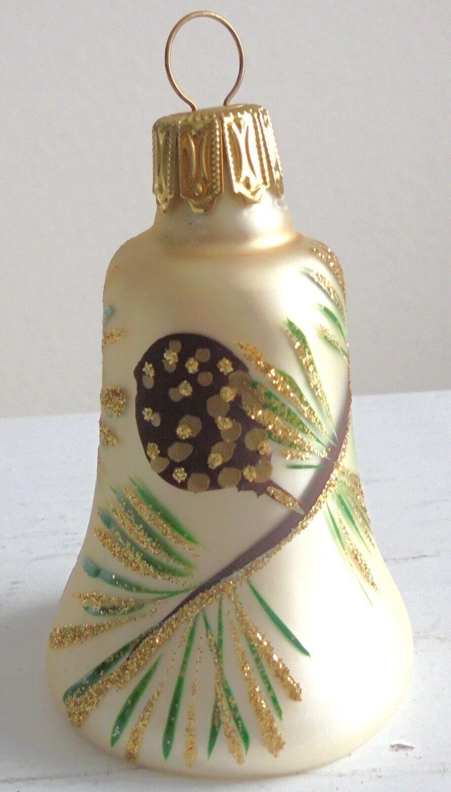
This first one fall into that latter category, as Mom and Dad gave it to me in 2012. It says "West Germany" on the top of the hanger, so that would date this Glocken (bell) to before the 3 October 1990 reunification of Germany. I found one via Google Lens described as vintage hand-painted blown mercury glass, champagne-colored with gold, green and brown leaves and gold glitter accents. It measures about 3 inches by 1.75 inches. The next three pictures show the complete design around the bell, which also has a bell-like indentation on the underside.
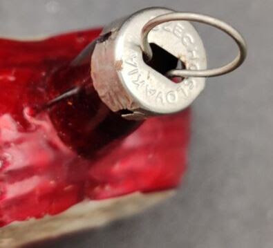
This heart ornament was also given to me by my parents in 2012. Embossed in the hanger top is "Czechoslovakia," so it dates to 1992 or earlier (The Czech Republic was formed 1 January 1993).
This snowman ornament was received in 2012 from Mom and Dad. The hanger top is embossed "Czech Republic," which dates it to 1993 or later.
The next three ornaments, a Santa and two Christmas trees, were also given to me by my parents in 2012. I found trees via Google Lens similar to these two described as mercury glass, which is also known as silvered glass. True mercury glass is free-blown double-walled, then silvered between the layers with solution containing silver nitrate and other materials, and sealed. It was produced originally around 1840 until at least 1930 in Bohemia (later Czechoslovakia, now the Czech Republic) and Germany, and in England from 1849 to 1855. There are many reproductions currently marketed as "mercury glass," which can be distinguished from antique silvered glass in several ways, including lack of a double wall. I don't think these three are true mercury glass.
"West Germany" is embossed in the top of this blue swirly ornament, so it would have been made prior to the reunification of Germany on 3 October 1990. This is assuming this is the original top. I have photos of this ornament in my tree in 2008, so I have had it at least that long - I'd have to ask my offspring if it might have been on an even earlier (1986 or later) tree. The design looks like it was created with an acrylic pour or dirty pour technique.
The next three ornaments have Inge-Glas Star Crown Tops on them, but I'm not sure those were the original tops. I liked the star top and may have used ones from broken ornaments to replace what was originally there. I haven't found any comparable ornaments using Google Lens. The third ornament (the red one) was purchased to replace another teardrop reflector ornament in a Pyramid (Rauch Industries) set that broke, and I think that was fairly recently, so it might be an Old World Christmas ornament.
Labels:
ornaments,
Treasure Chest Thursday
Subscribe to:
Posts (Atom)