
The map above summarizes my conclusions. Read on to find out how I got there.
Back in January 2021, when my husband’s first COVID shot was scheduled up on the 820 Loop around Fort Worth at the Azle exit, we decided to do a little exploring after the shot. We wanted to see if we could find the area where his mother was born.
There were some clues in my mother-in-law Jewel Moore Gresham's reminisces. which were in my last post:
- The log cabin was on Silver Creek. Her older sister Ivis thought it was on Little Silver Creek, which emptied into Big Silver Creek. These two creeks join each other in Parker County, just west of its boundary with Tarrant County, Texas. [Big] Silver Creek continues eastward and empties into what is now Lake Worth, a reservoir on the West Fork of the Trinity River built in 1914.
- The cabin was on land owned by Rufus B. Hagood, and I had enough information on his children from Jewel's memories to definitively find the family in historic records.
- The Hagoods had a larger house, which had a decent-sized hill behind it, across the creek from the Moores' log cabin. The Moores lived in these homes from about 1909 through 1918.
- Both houses were fairly close to the Live Oak School, which was apparently close to a Live Oak Creek.
This actually resulted in a pretty large area to look at:

You can click on the image of the map to make it larger. I marked Little Silver Creek and [Big] Silver Creek on the upper left of the map, and the red box shows the area where they join together. I also marked labels further downstream for Silver Creek, as well as Live Oak Creek at the bottom right of the map. You can see where they empty into Lake Worth on the right.
On our first drive-around in January, we took a look at an area further upstream (east, off the above map) on Little Silver Creek, near its headwaters in Parker County, that was a land grant to an R. K. Hagood (Richard Kenneth, older brother of Rufus). We also looked at the area near where Little Silver emptied into [Big] Silver - interestingly, part of a land grant to a John H. Moore, no relation.
We also checked out an area closer to Live Oak Creek, specifically a land grant to J. O. (James O., another older brother to Rufus) and R. B. (Rufus) Hagood. This piece of property did not seem likely for the cabins - it was only 41.65 acres (Jewel's father rented 80 acres), not on the water itself, nor was it good farmland.
Obviously, I needed to do more research before returning for the second COVID shot three weeks later. It turns out the J. O. and R. B. Hagood grant was very close to the location of the old Live Oak School.
I did another Google search on "live oak school" "fort worth" and there was a new result since my original blog post about the school in March 2013. Sometime after 2015, Wes Culwell, a Master Arborist, donated his files to the Tarrant County Archives. They included a number of City of Fort Worth Heritage Tree nominations - including one for the Live Oak School Post Oak.
I contacted the archives and was sent a copy of this September 2013 nomination, as well as a page about the tree in a book Culwell co-wrote. The school was located at the northwest corner of what is now the intersection of Silver Creek Road and Western Oaks Road. According to the nomination,
Live Oak School was part of the Tannahill School District and was open from about 1888 to 1922. The enrollment in 1920 was 27 students and in 1921 there were 20 students enrolled.The School Law of 1884 divided Tarrant County into 80 common school districts outside of the Fort Worth Independent School District. The Tannahill School became District No. 38. The original school was a couple miles west of the Live Oak School near the Tannahill Family Cemetery.1Mr. J. M. Orrick owned the land where the new Live Oak School was to be opened and he built a one room schoolhouse there in 1895. He received three payments for the school totaling $191.41. He signed a donation deed on April 8, 1895.....The Live Oak School closed in 1922 and consolidated with the nearby White Settlement School District No. 37....In 1938, the Live Oak Schoolhouse was on record as the oldest standing school building in Tarrant County, though not in use. In the same year the building was auctioned off for scrap for $78.
The nomination form included a photograph of the old school steps, as well as of a metal school piece of an old-style school desk found on the property. A house was built there sometime in the previous two+ years, so I’m not sure if the old school steps that were there in September 2013 are still there. The school itself was torn down and sold for scrap in 1938.
So, now knowing where the Live Oak School was for the 1908-1918 period when the Moore children would have attended it, I decided to look for maps from its 1895 to 1938 life - and hit the jackpot.
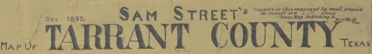
I found Sam Street's December 1895 Map of Tarrant County, Texas, on the Portal to Texas History (two other versions of it there, too). And right there on the map - the names Hagood and Orick [sic], the latter right where I expected it to be. Click on the image to make it larger.

The legend, in the upper right corner of the map, is quite helpful:

Note that churches and schools are indicated by a dark circle with a cross on top. Rectangles indicate houses occupied by owners, triangles houses occupied by renters. The names of the original patentees of the land [grant]s are in all caps, while the present resident owners are in upper- and lower-case script. The hatched lines (/////) are wagon roads.
So the large red box in the 1895 map image is just around the Hagood names and is not meant to indicate the extent of their property. The 1900 Census shows Rufus B. Hagood and his family in this area, with his older, never-married, childless brothers James O. and Robert L. Hagood living with him. Inside that larger box is a smaller red box around a rectangle that indicates the Hagood's home. Across Silver Creek is a triangle indicating a rental home, possibly the one the Moores lived in later.
Closer to the bottom of the map, another small red box surrounds the circle with cross on top indicating a church or school - in this case, the Live Oak School. Below that is a red box around the name of the landowner - J. M. Orick [sic]. Today's Silver Creek Road follows the wagon road on the 1895 map almost perfectly.
Although this map was made in 1895, based on Jewel’s descriptions, I suspect the main Hagood house and the rental house in were still in roughly the same place when the Moores moved there around 1908-1909.
The next step was to try to verify that the Hagood family actually owned this land around 1895 to 1918. For this, I combed extensively through Tarrant County deed records, mostly working backwards. Unfortunately, there is little online prior to 1920.
Luckily, even though the Rufus Hagood family moved away from the land (they were in the city of Fort Worth on the 1920 Census), they continued to own it - and it was apparently quite a lot. In a deed recorded (volume 1935, pp. 440-442, document #D147037213) on September 4, 1947, after the death of Rufus, his wife Sallie gave their three children a half-interest in the 726 acres she inherited.
That land was described in the deed, and between that, a lease recorded April 27, 1949 (volume 2083, pp. 61-65, document #D149014340) with this description:

and numerous other documents, I was able to map the Hagood Ranch at its peak, as well as the adjacent Wyatt Hedrick (the architect) and Thomas B. Ellison ranches:

In the map above (click on the image for a larger view), the red dots indicate the approximate locations of the houses the Moores and Hagoods may have lived in, and the small yellow square on the lower right is the Live Oak School two acres. The larger yellow vertical rectangle west of it is the original (pre-1895) Tannahill/Live Oak School site, which also contains the Isbell Cemetery. This twelve acres is still owned by the White Settlement Independent School District.
With a tool available online, I superimposed the 1895 Sam Street map over a topo map from the Texas General Land Office Land and Lease Viewer, and was able to make the map at the beginning of this post. It shows the rough locations of the houses, school, and old wagon road (which is today’s Silver Creek Road). The two houses are across Silver Creek from each other, with a slightly steeper hill behind the Hagood house, as Jewel described.
I think Jewel's older sister Ivis was remembering the junction between Mill Creek and [Big] Silver Creek, which was apparently close to the cabin and "big house," and not [Big] Silver and Little Silver Creeks, the intersection of which would have been much too far (seven miles one way) for the children to walk to Live Oak School. As it was, they would have walked about two miles one-way just to get to Live Oak School from the Hagood farm.
On our trip back to the area for Mark’s second shot, in early February 2021, we tried to drive as close as we could to the locations of the Hagood and rental houses. Unfortunately, while road maps indicate that might be fairly easy, we discovered that the roads to get into the area were now part of a gated community called La Cantera Estates. Pieces of the Hagood Ranch got sold off and divided among kids and grandkids, but it looks like much the original farm/ranch land is still intact, based on this satellite image.

NOTES:
1. The original Tannahill / Live Oak School was on a 12-acre vertical rectangular plot in the southeast corner of the George Isbell land grant, which also included the Isbell Cemetery in the northeast corner of the plot. The Tannahill Cemetery is nearby.
Great research! Our direct Hagood ancestry line goes from VA to SC, then Lemuel Davis Hagood goes to Georgia, his daughter Hannah married Charles Ledbetter. They both died in TX. No idea how they could be connected with the Hagoods of Plano area.
ReplyDeleteThis was my family’s homestead!! My grandfather sold off our section to a real estate developer. My father grew up going there as a kid and played in Silver Creek!
ReplyDeleteSara, thank you for commenting! Apologies for taking so long to approve it - I was out of town when you made the comment and I'm still catching up after returning a couple weeks ago.
Delete