...my parents, Geraldine Margaret Guokas (1928-2019) and Frederick Henry Pape (1929-2017) got married, September 11, 1954, at Annunciation Catholic Church in Houston, Texas. This photo is from their reception at the Milford House. The photo is by Kaye Marvins.
Sunday, September 11, 2022
68 Years Ago...
Labels:
Fred,
Gerrie,
Guokas,
Pape,
Sentimental Sunday
Wednesday, August 24, 2022
Happy Birthday to My Sweetie!
A picture from 40 years ago! Breathless is reading an E&B Marine Supply catalog on Contigo, his 27-foot 1969 Pearson sailboat he'd bought about a year earlier. I used this rather blurry picture to make a READ poster in a 23 Things activity on online image generators that my library did way back in 2008.
Labels:
Gresham,
Wordless Wednesday
Wednesday, August 3, 2022
Monday, July 18, 2022
Alonzo Peyton Gordon House in Granbury
This past Saturday, I went to a presentation by the Bridge Street History Center about Alonzo Peyton (A. P.) Gordon (1847-1921), an early settler here in Granbury, and his 1882 house, which is one block south of the History Center (itself in the 1879 D. L. Nutt - Watkins House).
Both of these places are just a couple blocks from my home. The Gordon House is now part of the Dora Lee Langdon Cultural Center, which includes all the buildings and grounds on the entire block, and is owned and operated by the City of Granbury.
Here's how the Gordon House looked in December 2021:
Above: A. P. Gordon House, Granbury, Texas, 22 December 2021 / Amanda Pape
The presentation included a handout with an old photograph of the house dated 1924. I don't have access to a good copy of that image, but the one above is similar. The presenter remarked that "some of our preserved houses sure don't look like they used to!"
That got me wondering what Sanborn fire insurance maps might tell us about the changing footprint of the house. Here's the house on the March 1893 Sanborn map, on the corner of Brazos and Pearl streets:
Above: Granbury 1893 Sheet 2 (cropped). Below: Granbury 1898 Sheet 1 (cropped). Both from the Perry-Castañeda Library Map Collection,
Sanborn Fire Insurance Maps - Texas (1877-1922), University of Texas at Austin.
The March 1893 Sanborn map doesn't make it very clear if the front porch (on the Pearl street side) is one story or two, but the July 1898 map (just above) does - it's two stories.
By the time the January 1905 Sanborn map was made, the front porch had been extended to wrap around the front and sides of the house, as shown below:
Above: Granbury 1905 Sheet 4 (cropped). Below: Granbury 1910 Sheet 5 (cropped).
Both from the Perry-Castañeda Library Map Collection,
Sanborn Fire Insurance Maps - Texas (1877-1922), University of Texas at Austin.
By the time of the July 1910 Sanborn map (above), the two-story porch had been extended around almost the entire house. The back wing that had the water tank had been removed, but the rest of that back wing had been extended to two stories.
The March 1945 Sanborn map (from the TexShare Proquest Digital Sanborn Maps, 1867–1970 database) shows the same configuration for the house. In the article "Chrysalis Rings New Theme in Old House" by Ardyce Pfanstiel in the March/April 1984 issue of granbury! The Journal of the Historic Brazos River Valley (volume 1, number 2, pages 26-28), I learned that the two-story porch was removed in 1956, as was the rear two-story wing, and the existing one-story kitchen addition was constructed.
So based on all this information, the old photograph near the beginning of this post would have been dated after July 1898 (the last Sanborn map that shows only a smaller two-story front porch).
However, I would date the photograph below (also undated) as falling sometime between July 1898 and January 1905 (the first Sanborn to show a two-story front porch wrapping around the front and sides of the building.
Why? Notice in the photograph below, you can see the projecting bay windows on the lower floor (as in the December 2021 picture at the beginning of this post). Those bay windows do not appear on the July 1898 Sanborn.
Above: A. P. Gordon House, Granbury, Texas, undated, between July 1898 and January 1905 / Dora Lee Langdon Cultural and Educational Center
Below: Combination of Granbury 1905 Sheet 3 (cropped) and Granbury 1905 Sheet 4 (cropped). Both from the Perry-Castañeda Library Map Collection,
Sanborn Fire Insurance Maps - Texas (1877-1922), University of Texas at Austin.
Click on the image to make it larger.
The 1905 Sanborn map above shows the sight line from the westernmost bay window (hidden under the two-story porch) to Gordon's store on the corner. I stepped into that window area while at the house, and sure enough, I could still see the building (formerly the Nutshell Bakery, now the Square Cafe, and St. Helens).
© Amanda Pape - 2022 - e-mail me!
Labels:
Granbury,
Mappy Monday,
Texas
Sunday, July 3, 2022
Happy Birthday to My Baby Brother!
Happy birthday to my brother Brian today, and to his lovely wife Paige, who has a birthday in a couple weeks. Photo is from September 15, 2012.
Labels:
Pape,
Sentimental Sunday
Thursday, June 30, 2022
Levi Marion Shelton's Land in Winn Parish, Louisiana - 1903
My last two posts have been about the location of the land belonging to my great-great-great grandfathers, Jacob Shelton (317.92 acres) and Levi Spikes (79.14 acres). Both were in Winn Parish, Louisiana, by 1860. Today I'm writing about the land of my great-great-grandfather, Levi Marion Shelton (1863-1941), Jacob's son, who married Levi's daughter Sarah Ann Spikes in 1884.
The process was the same as in the last two posts. First I used the United States Department of the Interior's Bureau of Land Management (BLM), General Land Office (GLO) Records Automation web site to find the location of Levi Marion Shelton's 1903 patent lands. On the patent details page, you could scroll down and use a mapping tool (checking the box in the Map column) to see just where Levi Marion Shelton's 157.11 acres were located (click on the image to view it larger):
I went to the State of Louisiana's Division of Administration Office of State Lands GIS & Data web page, and used the SONRIS Interactive Map linked there, choosing "Maps Historic 62.5k" as my background Imagery and using the Draw tool in the AOI Toolbox to draw lines on the map to roughly outline Levi Marion Shelton's patent. The result is the lighter green area below (click on the image to view it larger):
The background map, as discovered in my previous posts by exploring the United States Geological Survey's Historical Topographic Map Collection using a tool called topoView, was the 1950 Winnfield, Louisiana topo map, with a scale of 1:62500.
I grabbed a screenshot of the satellite image of this area from Google Maps, and used Microsoft Paint to outline Levi Marion Shelton's land. The result is below (click on the image to view it larger):
I found a final proof notice on page 5 of the November 22, 1901 issue of The Southern Sentinel (Winnfield, Louisiana), indicating Levi M. Shelton's intention to support his homestead claim on this piece of property. His witnesses includes L. E. (Levi) Drewett, who owned adjacent land; W. D. Drewett, who might be William Drewett, his nephew; and James Philan and Joab L. Durham, relatives by marriage.
On the oldest map I've been able to find (so far), the United States Department of Agriculture Bureau of Soils 1907 Winn Parish Soil Map, digitized by the University of Alabama, I zoomed in to the appropriate sections, grabbed a screenshot, and used Microsoft Paint to outline Levi M. Shelton's land, as well as that of his father Jacob Shelton and his father-in-law Levi Spikes. The result is below (click on the image to view it larger):
There are a couple small black squares (which mark buildings, such as houses) on the west side of Levi M. Shelton's property. Those were apparently gone by 1950. Levi Marion Shelton and his family had moved to adjacent Grant Parish by the time of the 1920 Census.
I also mapped the properties on the 2020 Atlanta, Louisiana topographic map, with a scale of 1:24000, to see roads and features as they appear in more modern time. The result is below (click on the image to view it larger):
Labels:
Louisiana,
Shelton,
Those Places Thursday
Monday, June 27, 2022
Levi Spikes' Land in Winn Parish, Louisiana - 1860
A couple days ago, I wrote about the location of the 317.92 acres in Winn Parish, Louisiana, where my great-great-great-grandfather, Jacob Shelton settled in 1859-1860. Today, I'm writing about the land of my other great-great-great grandfather, Levi Spikes (ABT 1805 - BET 1880-1900).
A search at the United States Department of the Interior's Bureau of Land Management (BLM), General Land Office (GLO) Records Automation web site for Spikes in Winn Parish, Louisiana, brought up four results: two for Levi Spikes, and one each for his son William H. Spikes (1832-1917) and Levi M[arion] Spikes (1867-1933). I'll get to them in a bit.
When I selected the two for Levi (each 39.57 acres, filed about two months apart in 1860), I got a page for each that provided details about the patents, with tabs to view the actual patent document image, as well as other documents (other patentees within the same land sections as Levi had). On the patent details page, you could scroll down and use a mapping tool (checking the boxes in the Map column) to see just where Levi's land was located (click on the images to view them larger):
These two parcels are next to each other. I went to the State of Louisiana's Division of Administration Office of State Lands GIS & Data web page, and used the SONRIS Interactive Map linked there to create a combined image. I chose "Maps Historic 62.5k" as my background Imagery and used the Draw tool in the AOI Toolbox to draw lines on the map to roughly outline Levi Spike's patents. The result is the lighter green area below (click on the image to view it larger):
The background map, as discovered in my previous posts by exploring the United States Geological Survey's Historical Topographic Map Collection using a tool called topoView, was the 1950 Winnfield, Louisiana topo map, with a scale of 1:62500.
I grabbed a screenshot of the satellite image of this area from Google Maps, and used Microsoft Paint to outline Levi's land. The result is below (click on the image to view it larger):
There's clearly been some settlement on the land, at least since 1950. That did not appear to be the case on the oldest map I was able to find (so far), the United States Department of Agriculture Bureau of Soils 1907 Winn Parish Soil Map, digitized by the University of Alabama. I zoomed in to the appropriate sections, grabbed a screenshot and used Microsoft Paint to outline Levi's land, as well as that of his two sons. The result is below (click on the image to view it larger):
I noticed there are no small black squares (which mark buildings, such as houses) within the Spikes properties. This 1907 map indicates some old roads and old communities that don't exist any more, such as Whitford and New Atlanta. It's possible that Levi and William, who were not required to live on their land as they acquired it though cash purchases, perhaps lived in one of these communities. By 1880, Levi and son William had both moved to adjacent Grant Parish.
Son Levi M. Spikes moved back to Winn Parish (from his father's home in Grant Parish) by 1894, and under the Homestead Act with which he acquired his land, would have had to live on and cultivate the land for five years before patenting it in 1905. Perhaps the 1907 map just doesn't include any structures he may have built there.
I also mapped the properties on the 2020 Atlanta, Louisiana topographic map, with a scale of 1:24000, to see roads and features as they appear in more modern time. The result is below (click on the image to view it larger):
Labels:
Louisiana,
Mappy Monday,
Spikes
Saturday, June 25, 2022
Jacob Shelton's Land in Winn Parish, Louisiana - 1860
Today (the last Saturday in June) is the annual Shelton Family Reunion in Louisiana. My great-great-great-grandfather, Jacob Shelton (ABT 1822 - AFT 28 Feb 1874), settled in Winn Parish sometime between March 10, 1859 (when a son was born in Copiah County, Mississippi) and July 2, 1860 (when he filed a patent for 317.92 acres). Recently I decided to try to find out just where that land was.
A search at the United States Department of the Interior's Bureau of Land Management (BLM), General Land Office (GLO) Records Automation web site for Shelton in Winn Parish, Louisiana, brought up three results: Jacob Shelton, his oldest son Joseph L. Shelton (1847-1869), and his youngest son (my great-great-grandfather) Levi M. Shelton (1863-1941). I'll get to them in a bit.
When I selected Jacob, I got a page that provided details about the patent, with tabs to view the actual patent document image, as well as other documents (other patentees within the same land sections as Jacob had). On the patent details page, you could scroll down and use a mapping tool (checking the boxes in the Map column) to see just where Jacob's land was located (click on the image to view it larger):
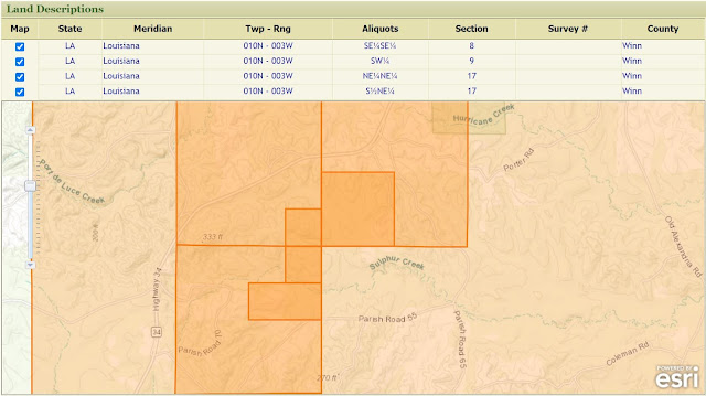
I wasn't too crazy about this map image, however. I didn't like all the extra orange shading (which marked the entire township/range, the section, as well as Jacob's aliquots). I also wanted a bit more detail in the base map. So I looked for some other tools.
I found the State of Louisiana's Division of Administration Office of State Lands GIS & Data web page, and used the SONRIS Interactive Map linked there. I chose "Maps Historic 62.5k" as my background Imagery, and used the Draw tool in the AOI Toolbox to draw lines on the map to roughly outline Jacob Shelton's patent, the lighter green area on the map. The result is below (click on the image to view it larger):
I was curious about the date of the background map, but there was nothing in the application to indicate what that was. I thought it was likely to be a United States Geological Survey topographic map, so I went to their website and found the Historical Topographic Map Collection. These can be explored using a tool called topoView.
I searched for Sardis, Winn Parish, Louisiana (because of the Sardis Church and Sardis Lookout Tower near Jacob's land on the historic map in SONRIS), and got 17 results. The first of these was also the oldest map, and matched the one above. It is the 1950 Winnfield, Louisiana topo map (Winnfield, the parish seat of Winn Parish, is just a bit to the north on my map snip above), with a scale of 1:62500.
I looked at the other 16 results for the newest map, and found the 2020 Atlanta, Louisiana map, with a scale of 1:24000. (Atlanta is a town just south on the road on my map snip above.) This meant I could get a sharper image when I zoomed in, and also showed roads and features as they appear in more modern time. I downloaded a copy of this map as a .JPG, and used Microsoft Paint to zoom in and mark Jacob Shelton's holdings (outlined in orange), as well as add some other notes to the map. The result is below (click on the image to view it larger):
It should be noted that what shows up as the "Swindelly Cem[etery]" on this map is not actually known by this name. Today it is called the Brown Cemetery (established 1857), although it has also been known in the past as the Brown-Swindle Cemetery. A large number of my relatives, including Jacob Shelton, are buried or have markers here.
The oldest map I was able to find (so far) is the United States Department of Agriculture Bureau of Soils 1907 Winn Parish Soil Map, digitized by the University of Alabama. I zoomed in to the appropriate sections, grabbed a screenshot and used Microsoft Paint to outline Jacob's land. The result is below (click on the image to view it larger):
The small black squares mark buildings (houses?) - the ones with crosses on top mark churches. On Jacob's land, in 1907 (a good 30 years after his death), it appears there were structures in section 9, near Sulphur Creek and the border with section 10, and in section 17. This 1907 map indicates some old roads that don't exist any more, and some that still do (the one called Lovell Road today, on the east side of section 9).
Finally, I grabbed a screenshot of the satellite image of this area from Google Maps, and once again used Microsoft Paint to outline Jacob's land. The result is below (click on the image to view it larger):
I thought it was interesting that, even today, you can see rough outlines of the old aliquots, forming a patchwork design on the land as viewed from space. If I had to make a guess, I would bet that Jacob settled in that area that appears bright green in the satellite view. It seems as though it might have been settled the longest.
Finally, I expanded the 2020 map a bit and outlined the land patents of Jacob's sons Joseph and Levi, as well as for other neighbors. The result is below (click on the image to view it larger):
Erby B. Barton (1877-1949), who patented his land in 1907, was a grandson of Leah Pickering Parton Spikes (1835-1903), my great-great-great-grandmother (more on Spikes land in a future post). Erby's mother, Parlee Porter Barton, was the sister of James A. Porter, who patented his land in 1906.
And finally, we have James P. Swindall, who patented his land the same year as Jacob Shelton, 1860. His name may be the source of the various names the Brown Cemetery has had over the years, Swindelly and Brown-Swindle.
© Amanda Pape - 2022 - e-mail me!
Labels:
Louisiana,
Shelton,
Surname Saturday
Sunday, June 19, 2022
Happy Father's Day
My dad, Frederick Henry Pape (1929-2017), with my siblings Mary, Mark, Brian, and Karen in front, spring 1968. I'm not in the photo because I'm the one taking it, with a Kodak Hawkeye Flashfun camera I got in 1966 (hence Karen is washed out).
Labels:
Fred,
Sentimental Sunday
Wednesday, June 1, 2022
Happy Birthday to My Son Eric!
Eric at Dinosaur Valley State Park, March 6, 2017.
Labels:
Wordless Wednesday
Subscribe to:
Comments (Atom)


