Showing posts with label Kenneth L. Anthony Photographic Collection. Show all posts

Sunday, May 28, 2017

Military Monday: World War I Memorial, Spohn Park, Corpus Christi, Texas

Corpus Christi has a World War I memorial in Spohn Park in the downtown area.  This memorial was dedicated in 1931 for the 39 Nueces County men killed in that war. It was originally called "The Gold Star Tree Court of Honor," (with the slogan "Some deeds must not die; some names must not wither," according to newspaper clippings in a 1931-32 scrapbook in the Lillie Mussett (Mrs. Sam) Rankin Collection at the Corpus Christi Public Library.  (The scrapbook also contains articles with, in some cases, photographs, of all 39 men honored.)

The original memorial consisted of bronze medallions for each serviceman with a crepe myrtle tree planted adjacent to it. The medallions and trees line the Broadway Bluff Balustrade on either side of Lipan Street (which is just above the words "World War Memorial" in the photo below). About 2,500 people attended the original dedication in 1931.  Back then, they had no idea there would be a second World War.

Here's how the memorial looked about nine years ago:


Above:  World War Memorial Gold Star Court of Honor [8 October 2008, with Corpus Christi Cathedral in the background] / Terry Ross / CC BY-SA 2.0

Below:  "Heroes All" [8 October 2008] / Terry Ross / CC BY-SA 2.0


Just to the right in the first photo, not visible in it, is the sign pictured just above.  In the background, next to the balustrade, you can see one of the medallions on a small post.

In a June 1932 photo, the sign can be seen on the base of what is now the flagpole in the upper left corner of the first photograph in this post, at the top of the bluff.  In that 1932 photo, the sign was illuminated with incandescent bulbs; later, those bulbs were changed to neon.  It appears that might have happened and the sign might have been moved around April 2000 as part of a restoration project, but it's not clear to me if the sign is lit today.  It is about level with the large granite monument pictured below, which was added in 2001.  The concrete letters and star reading "World War Memorial Gold *star* Court" were added sometime between May 1941 and November 1944.


Above: p1400003 [World War Memorial Gold Star Court of Honor, 8 October 2008, cropped] 

Below: p1400004 [World War Memorial Gold Star Court of Honor, 8 October 2008, cropped] 


Following are photographs and transcriptions of the 39 names listed in two panels on the monument:


Pvt Juvencio Almaraz
Pvt Tomas Alvarado
Pvt Benjamin Birmingham
Pvt Albert Blair
Pvt Tranquelino Bosque
1Lt Morris F. Briggs
Wagoner James H. Cade
Pvt Fred Cruz
Pvt William Cunningham
Pvt Robert Gillett
Pvt Fernando Gonzalez
Seaman Ernest Gragg
Pvt Arthur Grant
Pvt Jesus Guzman
Pvt Ben Hastings
Pvt Otto Hercek
Pvt Samuel H. Ingle
Sgt Wilbur F. Lane
Pvt Joe Maupin
Cpt George McDonald


p1400007 [World War Memorial Gold Star Court of Honor, 8 October 2008, cropped] Terry Ross / CC BY-SA 2.0
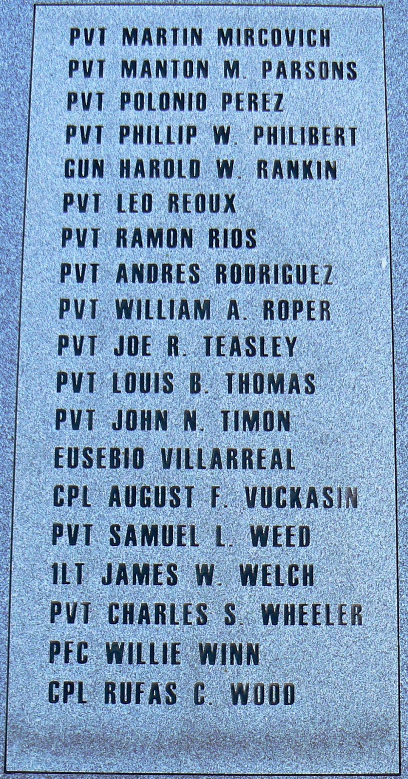
Pvt Martin Mircovich
Pvt Manton M. Parsons
Pvt. Polonio Perez
Pvt Phillip W. Philibert
Gun Harold W, Rankin
Pvt Leo Reoux
Pvt Ramon Rios
Pvt Andres Rodriguez
Pvt William A. Roper
Pvt Joe R. Teasley
Pvt Louis B. Thomas
Pvt John N. Timon
Eusebio Villarreal
Cpl August F. Vuckasin
Pvt Samuel L. Weed
1Lt James W. Welch
Pvt Charles S. Wheeler
PFC Willie Winn
Cpt Rufas C. Wood


 p1400008 [World War Memorial Gold Star Court of Honor, 8 October 2008, cropped] / Terry Ross / CC BY-SA 2.0


Other parts of the 2001 monument include a brief history of Spohn Park, where the memorial is located, and of the Gold Star Court itself:


Above left:  p1400005 [World War Memorial Gold Star Court of Honor, 8 October 2008, cropped] 
Above right:  p1400006 [World War Memorial Gold Star Court of Honor, 8 October 2008, cropped] 

Below:  Medallion with tattered flag at Gold Star Court of Honor, Spohn Park, Upper Broadway and Lipan.  October 2010.  Kenneth L. Anthony Photographic Collection, Item 212-158. Special Collections and Archives, Mary and Jeff Bell Library, Texas A&M University-Corpus Christi.  Used with permission of Kenneth L. Anthony.  


The bronze plaques were originally installed closer to the ground.  In 1999, the medallions were raised and restored, as pictured above and below:


Above:  Medallion memorializing Eusebio Villareal [note his name was spelled incorrectly on both monuments], Gold Star Court of Honor, Spohn Park, Upper Broadway and Lipan.  October 2010.  Kenneth L. Anthony Photographic Collection, Item 212-159. Special Collections and Archives, Mary and Jeff Bell Library, Texas A&M University-Corpus Christi.  Used with permission of Kenneth L. Anthony. 


Below:  Medallion memorializing Pvt. Louis B. Thomas [Tamez], Gold Star Court of Honor, Spohn Park, Upper Broadway and Lipan.  October 2010. Kenneth L. Anthony Photographic Collection, Item 212-160. Special Collections and Archives, Mary and Jeff Bell Library, Texas A&M University-Corpus Christi.  Used with permission of Kenneth L. Anthony. 


Here is the text of the Texas Historical Marker dedicated in a ceremony on November 10, 2016, Veterans Day (with some additions in brackets):

Gold Star Court of Honor

The Corpus Christi Gold Star Court of Honor pays tribute to the mothers of the servicemen of Nueces County killed during World War I (1914-1918). Incorporated into the existing Spohn Park, part of the Broadway Bluff improvements completed in 1916, this court was the first of its kind in the state when dedicated on March 22, 1931.

The court was a project of the Daughters of the American Revolution (DAR), led by Mrs. Sam (Lillie) Rankin, regent of the Corpus Christi Chapter. The DAR was joined by the American Legion, as well as local civic, religious and business groups. The Gold Star Court was designed by Mrs. Frank [Eloise] de Garmo. Instrumental in establishing Courts of Honor in northeast cities, de Garmo envisioned the memorial as a living space to honor the fallen servicemen who made the ultimate sacrifice in the ‘War to End All Wars.’ The city planted crepe myrtle trees and built a gold star light, three feet in diameter, outlined with yellow and white lamps; in the center read the words, "Our 1917 World War Gold Star Heroes." The gold star was located at the northern point of the highest terraces, and at the opposite end, Nueces County officials placed a magnificent flagpole. On August 2, 1932, a British 5-inch field piece and a 3-inch caisson and limber were added to the site [later removed]. Later, large concrete letters reading "World War Memorial Gold Star Court" were placed in a semicircle.

In 1988, Broadway Bluff, Spohn Park, and the Gold Star Court were listed in the National Register of Historic Places. The site fell into disrepair until volunteers undertook a restoration project in 2000. A private, city, and county effort, the Gold Star Court — the first in Texas — honors Nueces County’s revered heroes and their mothers.


This post was done in honor of Memorial Day for The Honor Roll Project begun by Heather Wilkinson Rojo of Nutfield Genealogy.

© Amanda Pape - 2017 - click here to e-mail me.

Sunday, November 27, 2016

Sentimental Sunday: Corpus Christi's Seawall

It may seem silly, but for me, my favorite thing in Corpus Christi is the seawall.  This two-mile stretch of steel-reinforced concrete connects my three places of work in the city, as well as other special spots for me.

It's also a link to the past for my husband, whose parents were living in the city while the seawall was being constructed (and were married during that time too).  My spouse remembers fishing on the seawall with his father in the late 1940s.


Above:  Two million dollar seawall now being completed at Corpus Christi, Texas. December 1940 /  Russell Lee / U. S. Government work, Library of Congress, Prints & Photographs Division, FSA/OWI Collection, [LC-USF34-038306-D].

Below:  South end of the Corpus Christi Seawall.  McGee Beach is to the left, McGaughan Park is to the right.  The benches and the Mirador (the white gazebo) were added after we moved away.  The Emerald Beach Hotel can be seen at the end of McGee Beach; it was the Holiday Inn - Emerald Beach when we lived there in the late 1970s and early 1980s.


The seawall has an interesting history.  I had not realized that Mount Rushmore sculptor Gutzon Borglum was invited to design a seawall for the city in 1927 (his design was not adopted).  I also did not know that the two million dollar project (from bond funds and from the state's share of property taxes from seven South Texas counties) also built the two T-heads and the L-head of the Marina.

The Corpus Christi Seawall is a Texas Historic Civil Engineering Landmark, designated by the American Society of Civil Engineers Texas Section.


Above:  P1000835.JPG [16 April 2007] / John M. P. KnoxCC BY-SA 2.0

Below:  State historical marker installed in 2015 has an error in it.  I think a zero is missing.  It's not 1,100 feet long - that would be just two-tenths of a mile.  Two miles is 10,650 feet, so I think the 1,100 is supposed to be 11,000 (or maybe 11,100).


The seawall, of course, also created the beautiful downtown bayfront area, by adding five hundred feet of mostly-city-owned land.  Prior to its construction, Water Street - so named because it was then at the water's edge - was the eastern boundary of downtown.  The wide sidewalk of the seawall itself is a great place to walk, run, bike, skate, and pedal.


Above:  Aerial view of city [of Corpus Christi] looking northwest from [Corpus Christi] bay, ca. 1984. (Dated by construction of Corpus Christi Central Library building.)  Professional photograph by unidentified photographer furnished to KZTV-10 for use in advertising.  Kenneth L. Anthony Photographic Collection, Item 212-118. Special Collections and Archives, Mary and Jeff Bell Library, Texas A&M University-Corpus Christi.  Used with permission of Kenneth L. Anthony.  
Click on the photo to enlarge it.

Below:  Detail from the aerial view of city looking northwest from bay, ca. 1984, cropping out much of the top and bottom.  Kenneth L. Anthony Photographic Collection, Item 212-118 (detail). Special Collections and Archives, Mary and Jeff Bell Library, Texas A&M University-Corpus Christi.  
Used with permission of Kenneth L. Anthony.  Click on the photo to enlarge it.


Unlike my husband, I never did any fishing from the seawall, but I have lots of good memories.  Sometimes it was as simple as walking over from my place of work to have lunch and catch a little sun and seabreeze on its steps. I watched the activity in the marina, from shrimp boats returning in the early morning with their overnight catches, to Wednesday night regattas.  I watched Bayfest boat parades and Anything-That-Float-But-A-Boat races, and Fourth of July fireworks from those steps.


Above:  Image from the map I bought when I moved to Corpus Christi in 1979.  The seawall runs all along the right side of the city on this map, from the Art Museum of South Texas in the Bayfront Science Park (the green area at the top) all the way down to the south end of McGaughan Park and McGee Beach (the green area at the bottom).  What is called the "sea wall" on this map is actually the breakwater, which was constructed in 1924 to facilitate the port. 
Click on this image to enlarge it. 

Below:  These markers appear periodically along the seawall sidewalk, all in blue with a palm tree and different numbers.  I have not been able to find out what they mean.  I don't think they were there when I lived in Corpus Christi, 1979-1984.


It's still a spot that calls to me.


© Amanda Pape - 2016 - click here to e-mail me.

Sunday, November 20, 2016

Sentimental Sunday: Nueces County Courthouses, Then (1975-77) and Now (2014-16)

Two blocks west of my original place of work with the City of Corpus Christi (222 Belden) was the 1914 Nueces County Courthouse.  During my years in the City (April 1979 through October 1984), the building was in fairly good shape.  It had suffered some damage from Hurricane Celia in 1970, which led to the County government deciding to put construction of a new courthouse on the ballot.  The bond issue was approved, and the County moved into its new courthouse up on the bluff in 1977.


According to the 1978 application for the historical marker,

The Greek neo-classical building originally was T-shaped but 1930 additions to the west have created a cruciform shape.  Rising six stories above ground, the reinforced steel building is faced in soft gray brick with white classical terracotta trim and is crowned with a red roof, originally of tile.  The building contains quantities of marble and ornate iron work....An open well soars through three floors and the double grand staircase features the marble as well as the iron work.

You can get some idea of what the interior offices of the 1914 Courthouse looked like in 1934 from the work of an itinerant photographer (all but the first two images).


Above: (Old) Nueces County Courthouse (15 July 2015) / Jimmy Emerson, DVM / CC BY-NC-ND 2.0

Below:  Bas relief figures at top of east wing, 20 June 2016


It's not clear to me what the four bas relief terracotta figures at the top of the main (east) entrance are supposed to represent.  One source said they are the four Cardinal Virtues, and the one on the far left is clearly Justice, with the blindfold, sword, and balance scales.  The one on the far right appears to be holding a Masonic symbol.  It's interesting that those two are depicted as angels, and the other two are not.

The south wing of the building was restored with various grant funds in 2004-2006.  Although some of the doors and windows have since been boarded up for security, the project demonstrated that restoration of the building is possible.  Otherwise, though, the County has done little to maintain or protect the building, and it has suffered from vandalism, scavenging, and neglect.  The building can't be demolished before September 1, 2027, because of a preservation easement placed on the building by the Texas Historical Commission when the county accepted the renovation grants.


Above:  Carytids at south wing entrance, 20 June 2016

Below:  Restored south wing roofline, 20 June 2016


The "new" (1977) Nueces County Courthouse is very different in style.


Above:  Nueces County Courthouse (September 1975, cropped) / Jay Phagan / CC BY 2.0


My husband particularly likes these two art pieces in the atrium of the 1977 Courthouse:


Above:  Longhorn skull and horns in atrium of 1977 Nueces County Courthouse, 17 June 2016.

Below:  Seagulls in atrium of 1977 Nueces County Courthouse, 17 June 2016.


As can be seen on the map below, what really doomed the old (1914) courthouse, in my opinion, was the construction of the Harbor Bridge (Highway 183) and extension of Interstate 37 in 1957-59.  The two major roads wrap around two sides of the building, eating away at the original courthouse block.
Various attempts have been made over the years to reuse the building, but all have fallen through.


Above:  Image from the map I bought when I moved to Corpus Christi in 1979.  The Old Nueces County Courthouse is the red cross-shaped building at the northeast corner of the intersection of Interstate 37 (which runs east from the west edge of the map) and US Hwy 181 (which runs south from the north edge of the map).  The current Nueces County Courthouse is in the orange T-shaped area in the center of the map. Click on this image to enlarge it.  

Below:  Aerial view of city [of Corpus Christi] looking northwest from [Corpus Christi] bay, ca. 1984. (Dated by construction of Corpus Christi Central Library building.)  Professional photograph by unidentified photographer furnished to KZTV-10 for use in advertising.  Kenneth L. Anthony Photographic Collection, Item 212-118. Special Collections and Archives, Mary and Jeff Bell Library, Texas A&M University-Corpus Christi.  Used with permission of Kenneth L. Anthony.  Click on the photo to enlarge it.


Although a bit difficult to see in the image below, the entry to the Harbor Bridge wraps around the south (facing) and west sides of the old courthouse.  There is also a pedestrian overpass with a circular ramp that's directly in front of the south wing.


Above:  Detail from above aerial photo, showing the 1914 Nueces County Courthouse. Kenneth L. Anthony Photographic Collection, Item 212-118 (detail). Special Collections and Archives, Mary and Jeff Bell Library, Texas A&M University-Corpus Christi.  Used with permission of Kenneth L. Anthony.

Below:  Detail from above aerial photo, showing the 1977 Nueces County Courthouse.  In the foreground are cranes working on construction of the new Corpus Christi Central Library, which helped date this photo to late 1984 or early 1985.  Kenneth L. Anthony Photographic Collection, Item 212-118 (detail). Special Collections and Archives, Mary and Jeff Bell Library, Texas A&M University-Corpus Christi.  Used with permission of Kenneth L. Anthony.


There are plans to construct a new bridge over the Corpus Christi Ship Channel, and remove the existing Harbor Bridge.  This could open up some options for development of the 1914 Courthouse, with one possibility being a luxury apartment complex.  Recently the county put the courthouse on the market.  I do hope the building is purchased, restored, and put to good use.


© Amanda Pape - 2016 - click here to e-mail me.

Sunday, November 13, 2016

Sentimental Sunday: Corpus Christi's Floating Restaurant, Then (1982-84-85) and Now (2009-2016)

Sometime before December 1980, a new restaurant opened in the Corpus Christi Marina, on a floating barge docked at the Peoples Street T-Head.  My husband and I think it might have been that very month, because Hurricane Allen inflicted huge damage on the Marina in August 1980, so the area was ripe for development.  I have a photograph of the restaurant with Christmas lights (not as sharp as the two below) taken in December 1980, and the first review in Texas Monthly shows up in January 1981 (page 28):

"First let's talk about the food, ignoring the stunning setting for a moment.  The fare you'll find here is ordinary beef and reef - a little boring.... Now, the atmosphere. Floating in the water with a view of city lights on one side and Corpus Christi Bay on the other, the boat has an absolutely mesmerizing quality.  A warning to landlubbers: the place bobs with the bay so watch those martinis and get your sea legs under you." 

Reviews didn't get any better over the next year and a half.  This one from the September 1981 Texas Monthly (page 46) was particularly harsh:

"A reasonably apt comparison can be made between this restaurant and the proverbial dumb blonde: terrific looks, fun to be around, but not much substance when you get down to basics - in this case the food.  But it doesn't make much difference; the spectacular location and proximity to the new convention center keep the decks filled with conventioneers and atmosphere-starved locals."

By June 1982 (Texas Monthly, page 43), though, "Local aficionados go elsewhere to find serious seafood."  By January 1987, Captain Boomer's closed.


Above: Captain Boomer's barge restaurant at People's Street T-head. 1982.  Kenneth L. Anthony Photographic Collection, Item 212-32. Special Collections and Archives, Mary and Jeff Bell Library, Texas A&M University-Corpus Christi.  Used with permission of Kenneth L. Anthony.

Below: Captain Boomers, taken circa 1985 / Jay Phagan / CC BY 2.0 


You'll note in the photo above a sailboat docked next to the restaurant.  I had to look closely to make sure it wasn't my husband's boat!  He tells a story of sailing one day with his best friend, a co-worker, and stopping there for a drink and dinner.  He also remembers going there once and the restaurant being called by his boss, the city manager, who was looking for him!

I only remember eating at Captain Boomer's once. I know my youngest sister Mary was with me, and I only remember her visiting with our mother in March 1981, so it must have been then.  I remember a guy who claimed to be a son of millionaire Sam Walton was at a nearby table, and he flirted with my sister, who was only 16 at the time.

Captain Boomer's was taken over by new management and reopened as C. C. Dockside in early 1987.  Based on a profile I found for a general manager / operating partner, it went under that name until at least January 1992.  In late 1990, the owners added a "long, narrow deck along the water" next to the barge, still moored on the leeward far side of the Peoples Street T-Head, according to a review on page 199 of the October 1990 Texas Monthly.  Landry’s purchased the restaurant in June 1991.


Above: Aerial view of city [of Corpus Christi] looking northwest from [Corpus Christi] bay, ca. 1984. (Dated by construction of Corpus Christi Central Library building.)  Professional photograph by unidentified photographer furnished to KZTV-10 for use in advertising.  Kenneth L. Anthony Photographic Collection, Item 212-118. Special Collections and Archives, Mary and Jeff Bell Library, Texas A&M University-Corpus Christi.  Used with permission of Kenneth L. Anthony.  Click on the photo to enlarge it.

Below:  Detail from above photo of the Marina area, showing Captain Boomer's floating barge restaurant at the top, and the Marina office / Lighthouse restaurant at the bottom.  The large white boat to the left is the Flagship, a tour boat that operated out of the Corpus Christi marina, likely with the Gulf Clipper, another tour boat, next to it.  All are docked at the Peoples Street T-Head, the uppermost of the three Marina heads in the photo above.  The Lighthouse / Marina office was on the Lawrence Street T-Head. Kenneth L. Anthony Photographic Collection, Item 212-118 (detail). Special Collections and Archives, Mary and Jeff Bell Library, Texas A&M University-Corpus Christi.  Used with permission of Kenneth L. Anthony.


You can see where Captain Boomer's was located in the detail image above from about 1984.  Another restaurant had opened in the Marina by that point.  Hurricane Allen destroyed the Marina office on the Lawrence Street T-Head in August 1980.  In 1982, four local businessmen offered to construct a new building that would do double-duty as an office and a restaurant, leasing the land from the City of Corpus Christi.  The Lighthouse Restaurant opened in 1985 and closed on Halloween 2000.  It later reopened as a Joe's Crab Shack.  A new Marina Boaters Facility was completed in March 2006, separating the office from the restaurant.

The picture below shows the floating barge restaurant (now Landry's) in 2009 at approximately the same angle as the first photo in this post, from 1982.  Barely visible in the background on the left is the Harbor Bridge, which is clearly visible in the first picture.  Numerous boat slips (some of them floating) were added to the Peoples Street T-Head between 1982 and 2009.


Above:  Corpus Christi Marina [7 September 2009] / Matt Malone / CC BY-NC 2.0

Below:  Image from the map I bought when I moved to Corpus Christi in 1979.  The Marina is the green extensions into Corpus Christi Bay on the right (click on this image to enlarge it).  


When we visited Corpus Christi in June 2016, I took some photos of the Marina from the balcony of our hotel room.  In the photo below, you can see Joe's Crab Shack (the former Lighthouse restaurant) on the far upper right, at the corner of the Lawrence Street T-Head.  Almost all of the Peoples Street T-Head is visible in the photograph, with the Landry's Seafood House floating barge restaurant in the lower left quadrant of the photo.  (Click on the photo to enlarge it.)


Above:  Peoples Street T-Head, Corpus Christi (Texas) Marina, 20 June 2016.

Below:  Landry's Seafood House floating barge restaurant, Corpus Christi, Texas, 20 June 2016.


Above:  Joe's Crab Shack (the former Lighthouse Restaurant), Corpus Christi Marina, 20 June 2016.

Below:  Harrison's Landing, Corpus Christi Marina, 20 June 2016.


New in the Marina since our 2006 visit to Corpus Christi is Harrison's Landingbetween Landry's and Joe's in the Marina photo above.  It includes a restaurant that is mostly outdoors, the areas with the colored lights in the photograph above.  It's operated by the same Harrison family that ran the Lighthouse and Cooper's Alley.


© Amanda Pape - 2016 - click here to e-mail me.

Thursday, November 10, 2016

Those Places Thursday: Corpus Christi City Hall, Then (1952, 1955, 1984) and Now (2016)

My husband and I made a couple visits to Corpus Christi, Texas, this past summer, which was our stomping grounds from 1974 to 1985 (for him) and 1979 to 1984 (for me). My husband also spent some time in his childhood in the 1940s in Corpus Christi (his parents, like us, married there), and both of us have ancestral and collateral relatives who lived here in the late 1800s and first half of the 20th century.

During the time I lived there, I didn't think to take pictures of some of the places I worked in or saw frequently. I guess I thought those buildings would always be there. Naturally, that was not the case.  Luckily, I have been able to locate other images to use.

Today's post about Corpus Christi's City Hall (the one there when we were there) falls in that category.  My husband worked in this building the entire time he lived in Corpus Christi, and I worked in the building from April 1983 through October 1984 (although I visited it many times before that).  Here is a postcard image from the library's special collections at Texas A&M University-Corpus Christi (where I earned my MBA back when it was called Corpus Christi State University):


Above:  Postcard showing two sides [north and east] of City Hall on Shoreline Drive, Corpus Christi, Texas, ca. 1955, with the Utilities Building in the background on the left.  
Kilgore Picture Postcard Collection, Item 7PC-781. Special Collections and Archives, 
Mary and Jeff Bell Library, Texas A&M University-Corpus Christi.

Below:  view of west and south sides of City Hall on Shoreline Drive, Corpus Christi, Texas.  From a National Register of Historic Places registration form available at the Texas Historical Commission.


Guidelines set out in 1949 by the Mayor’s Civic Improvement Committee suggested that City Hall should “be plain, simple, true and honest architecture without any applied bric‐a‐brac or needless ornamentation to be exposed to the erosion by weather and thus become a future maintenance problem,”according to an article in the local newspaper published the day the building was dedicated (March 23, 1952).  It went on to say,
At the outset of planning, architect’s representatives concurred with City officials to determine what was desired, what was absolutely needed, and then decided what was available within the construction fund….City Hall on Shoreline is a five-floor concrete, brick and masonry structure of  "contemporary" design.
...with a framework of reinforced concrete…it was designed to meet present day demands, and took into consideration the materials available at the time of construction.1  

This was due to a continuing postwar shortage of steel.  There was also a

recommendation that office arrangements be made as flexible as possible, because of the constantly changing needs of a City Hall....the partitions separating most offices are 2-inch wide plaster on steel mesh.  With a minimum of effort and expense, they can be removed and shifted about.1
The article further states,
The building waxes from moderate splendor …[to] simple but modern utility in design and décor.  Reddish tan brick, selected for durability and economy…is the principal material used on the exterior.  Plaster, in a varied assortment of subtle and striking colors, and varied arrangements of wood paneling form most interior walls.  Arkansas ledge stone and gray-green slate" were also used, and even the elevator doors were originally painted bright yellow.1 
According to another article in the same issue,

Architect Richard Colley placed much emphasis on lighting in designing the new City Hall….the building faces due north [even though this meant the building appeared to be slightly askew in relation to the street grid]. It was located in this manner so windows on the north side of the building extend down the face of the building to include the basement. Windows in the basement, the architect envisioned, give people working there the benefit of natural light and also presents the illusion [of] being above instead of [below the] earth.2

Having worked in an office on the north side of the daylight basement, I would agree that the natural lighting was good.  Plantings outside helped some with that "illusion" of being above the earth - but it was just an illusion.

On the south side of the building, "a giant grille-shades the windows"2 from direct sunlight and heat.  This concrete grill, visible in the black-and-white photograph above, is called a brise‐soleil, and I can attest (from my husband's prior offices on the second floor) that they worked.  Further adding to before-its-time energy savings, "there are no east or west windows except for small non-opening windows [to allow natural light] in the stair towers at either end."2


Above: Aerial view of city [of Corpus Christi] looking northwest from [Corpus Christi] bay, ca. 1984. (Dated by construction of Corpus Christi Central Library building.)  Professional photograph by unidentified photographer furnished to KZTV-10 for use in advertising.  Kenneth L. Anthony Photographic Collection, Item 212-118. Special Collections and Archives, Mary and Jeff Bell Library, Texas A&M University-Corpus Christi.  Used with permission of Kenneth L. Anthony.  
Click on the photo to enlarge it. 

Below:  Detail from the aerial view of city looking northwest from bay, ca. 1984, of City Hall and the Utilities Building. Kenneth L. Anthony Photographic Collection, Item 212-118 (detail). Special Collections and Archives, Mary and Jeff Bell Library, Texas A&M University-Corpus Christi.  Used with permission of Kenneth L. Anthony.  Click on the photo to enlarge it.


So why was this award-winning building torn down in 1988?  One problem was that the construction budget was limited, and the building was too small from the outset:

It was not built with a view toward any future expansion upward or extension outward.  As for future space needs, Architect Richard Colley and his staff have in mind the addition of an entirely separate building on the City Hall site.  It could house the Public Works Department, thereby freeing the fourth floor of the present building for other offices …This additional building would harmonize with the City Exposition Hall and the proposed …Memorial Auditorium.1

Indeed, a Utilities Building was constructed just south of City Hall in 1955.  It is visible in the color photo at the beginning of this post, just past and to the left of City Hall.  It can also be seen in the 1984 aerial photo detail.

A new, larger City Hall was constructed in 1988, up on the Bluff near the 1977 Nueces County Courthouse.  Citizens (understandably) did not want a tall building so close to the waterfront.  Colley's 1952 building (along with the Utilities Building) were demolished in the summer of 1988.  Today, a park with a gazebo, a shaded picnic table, and a small playground stand on the site.  All of the parking areas that surrounded the former buildings still exist.


Above:  image from the map I bought when I moved to Corpus Christi in 1979.  The Civic Center Complex is the large green area at the bottom of the map (click on this image to enlarge it).  City Hall was located at the small red dot near the top of it, at the intersection of Shoreline Boulevard and Kinney.

Below:  1952-1988 Corpus Christi City Hall site on June 20, 2016, as viewed from Sherrill Park.


These last two pictures roughly mirror the views in the first two pictures in this post:


Above:  Looking south through Sherrill Park in Corpus Christi on June 18, 2016, towards the site of the 1952-1988 City Hall, similar to the view in the 1955 postcard.  The World War II memorial formerly on the Memorial Coliseum is the red brick structure in the foreground.

Below:  Looking north through the park on the site of the 1952-1988 City Hall on June 20, 2016, similar to the view in the 1952 black-and-white photo.


End notes:

1“Many Factors Influenced Design of New City Hall” Corpus Christi Caller‐Times, March 23, 1952, page 21.
2“Manner of Lighting Played Major Part in City Hall Plans” Corpus Christi Caller‐Times, March 23, 1952, page 22.


© Amanda Pape - 2016 - click here to e-mail me.