Tuesday, March 31, 2020

Happy 70th Birthday to My Cousin Mare!


Marianne Monica Streff as a flower girl in the wedding of her uncle Bob Pape and aunt Lorrie Olker, June 19, 1954.


© Amanda Pape - 2020 - e-mail me!

Sunday, March 29, 2020

Sentimental Sunday: 1893 Building Permit for 1043 Sherman Avenue, Evanston, Illinois - Revisited

A little over a month ago, I was contacted by one of the current owners of the house my great-grandfather,  John Pape (1851-1945), lived in from at least 1882 to at least 1925, at 1043 Sherman Avenue in Evanston, Illinois.  She'd discovered my posts in this blog related to the house.  In talking with her, I decided to revisit my earlier post about the building permit for this house.

First, the grantor-grantee index for this plat from the Cook County Recorder of Deeds office indicates John Pape acquired the lot in September 1882 (see the last line) from developer John H. Connor:


According to Connorton's Evanston Directory, 1882-83, the home of John Pape was on the "w[est] s[ide of] Sherman av s[outh of] Greenleaf."  The 1883 directory, which includes a separate listing for the village of South Evanston, says his home was at "Sherman ave se cor[ner] Greenleaf." By the 1889 and 1890 directories, it is "e[ast] s[ide] Sherman av 2d s Greenleaf."  The abbreviation "d" is not explained in the guide, but I think this must mean two doors south of Greenleaf.

In the 1893 directory, the address is "207 Sherman ave s" which was its address in South Evanston, platted in 1868 and incorporated as a village in 1873.  In 1892, South Evanston was annexed into Evanston, which was incorporated as a city. The new city began issuing building permits in October 1892 and renumbered the entire street system in 1893.  The address is given as 1043 Sherman Avenue in the 1894 directory.

I had always wondered if my great-grandfather, who started out as a carpenter, built that house.  I think he may have - but I don't know for sure, given that the house existed before the city started issuing building permits.  It turns out that I missed a detail on the April 1893 building permit I found at the Research Room and Archives at the Evanston History Center in August 2017.  The permit wasn't for a house; it was for "house impvt" - improvements! (Click on documents throughout this post to enlarge them):


The "Application for Building Permit" above and the "Permit Granted" form below were the oldest in the file for this address, and were both dated April 7, 1893.  The two-story with basement improvements (apparently designed as well as built by John Pape) would have nine rooms and be 28 feet wide, 35 or 35.5 feet deep, and 30 feet tall.  It would include a water closet with sink, bathtub, and toilet bowl, be heated by steam, and lighted by gas.   The total cost of building was estimated to be $800, and the mason was James Wigginton.  The legal description of the property at the time referred to the south quarter of Lot 2 of the J. M. Meyers Subdivision (lot 6 according to the tax accessor).  The building permit cost $2.


Apparently there was an additional fee to pay for water service, based on the amount of brick and plaster used in the house, according to a note on the back of the previous document:


The next form is a bit puzzling.  Although the date written on it is April 7, 1893, it is written on a form printed for the 1920s.  It doesn't tell us anything new, and some of the details (depth of house, and subdivision name) are slightly different - perhaps information copied incorrectly from the original permit:  


In retrospect, I think this might have been some sort of card originally filed on its side in a box, based on the data in the left margin, and the fact that there's a card with similar printing for the 1920 addition of a separate frame garage (see the original post for more on that permit).

There was no Sanborn map for this property prior to 1893.  However, I found similar type of map for 1891 at the Historic Map Works website in a set called "Chicago Suburban Maps, Cook County, Ill's. published by the Central Map, Survey and Publishing Co. 148-154 Monroe Street, Chicago. August 1891."  The original maps are available at the Library of Congress.

The relevant map is Sheet 22.  Here's an enlargement, below with location outlined in red (click on the image to make it larger).  Note that the address is off, it should be 207; the correct 206 is across the street.  Note also that the house (marked with a D) is only one story.  The smaller building in the back left-hand corner of the lot is identified as a kitchen.


The image below is from the 1899 Sanborn map available from the Library of Congress (rotated to match the orientation of the map above).  The lot at 1043 Sherman is outlined in red.  The house is now mostly 2.5 stories with a bigger footprint.  You can clearly see the bay extension on the right side, visible in the photographs further down in this post.  There's still a one-story building in the back left-hand corner of the lot, but that is gone by 1920.


Below is a photograph of the house, circa 1975, from a real estate listing that was in the file at the Evanston History Center.  Note the garage to the right, near the back of the lot.  The current owner tells me the garage is gone, and that she removed the dormers visible along the roof on the right.  The stairway to the front door has also been reconfigured.


These changes can be seen in my 2017 photo below:


It's not clear to me if John Pape, in 1893, just added on to the existing house at 1043 Sherman Avenue, or if he tore it down and started over.  Hopefully the current owner might find some clues about that.  Watch for future posts about interesting things she found inside the house!


© Amanda Pape - 2019 - e-mail me!

Thursday, March 26, 2020

Those Places Thursday: Dienes Hat Store Chicago Location


Recently I used Sanborn maps (available through the Library of Congress) and the Chicago Building Permits Digital Collection (available through the University of Illinois at Chicago) to trace the history of the Chicago home of my great-great-grandparents' Dienes Hat Store, which was located at 287 [later 460 W.] Division from at least 1888 to at least 1891. 

The photo above, from somewhere around 1888-1891, has my great-great-grandparents Regina Matheis Dienes (1837-1916) and Friederich "Fred" Wilhelm Dienes (1827-1896), and one of their daughters, probably my great-grandmother Elizabeth Regina Dienes Massmann (1876-1946).

Using the index, I found two building permits for this address.  The first gave both the post-1909 renumbering and pre-renumbering addresses. and I could clearly read that it was permit #565, but it was hard to read the date.  March 20-something, 18-something?


Using some of the image enhancement tools made it a little easier to read.  I could see the year was 18-6, and guessed it was likely to be 1866, 1876, or 1886.  Probably the latter, because the hat store was originally (according to the 1882 city directory) just down the street at 267 (later 470 W.) Division.


Here are the pages with this building permit (click on the image to view it larger):


I did a little editing to cut out unnecessary entries and make the date of the permit clear (March 25, 1886), as well as the headings on the page.  Here is the left side of my modified page.  Permit #565 is listed on the bottom (click on the following two images to view them larger):


The owner was German immigrant Frederick Buenzow (1825-1910, see above).  He arrived in the USA in 1853, but by 1886 was apparently doing well enough to erect a four-story store and flats, 22 feet wide, 52 feet deep, and 40 feet high.  The site was in Butterfield's Addition, lot 34, sublot 38, and the permit cost $4.60 (below).  Buenzow is at this address in the 1888 city directory (along with the Dienes hat shop in the storefront), but he's moved to 27 (now 1218 N.) Clybourn by the 1891 directory, and the Dienes family lives above the store.


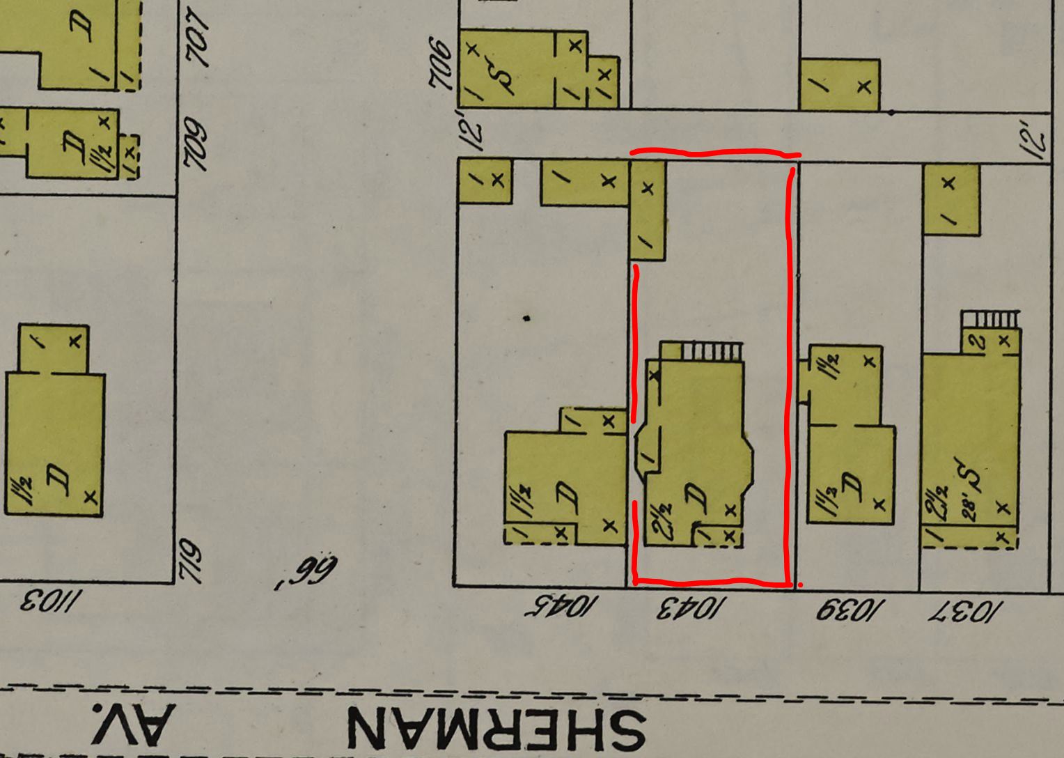
Here's the Sanborn map for this block from 1910, when it was pretty much fully developed.  My family's interest in the property ended by 1896 when my great-great-grandfather Fred Dienes died.


Image 94 of Sanborn Fire Insurance Map from Chicago, Cook County, Illinois, Vol. 2, 1910 [part].
Image provided by: Library of Congress, Washington, DC, Geography and Map Division.


By the time of the 1935 Sanborn map (below), all of the entirely-frame (all-yellow) buildings were gone, while a few other buildings had been enlarged.  Although the photograph at the beginning of this post shows that it was there all along, this map indicates that there is an "area under side walk" that provided access to basement levels of the six addresses from 460 to 470 W. Division.


Image 53 of Sanborn Fire Insurance Map from Chicago, Cook County, Illinois, Vol. 2, 1935 South [part].
Image provided by: Library of Congress, Washington, DC,Geography and Map Division .


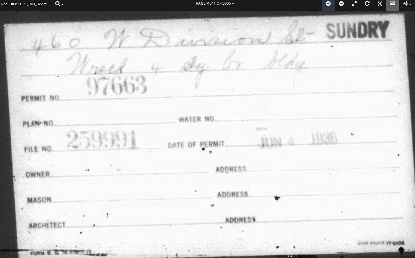
The other permit for this address is a "sundry" permit, which is usually for alterations.  This one was also hard to read:


Enhancing the image made it a little easier - I can now clearly read the date (June 4, 1936), and it looks like it is to "wreck 4 st[or]y b[ui]ld[in]g" - in other words, a demolition permit.  I could not find any other detail about this permit.


Sure enough, by the April 1950 Sanborn map update, 460 W. Division is gone, as are some more buildings on the block.  A gas filling station has gone in at the top part of the wedge, along N. Clybourn Avenue.


Image 53 of Sanborn Fire Insurance Map from Chicago, Cook County, Illinois, Vol. 2, 1910 - May 1950 South [part].
Image provided by: Library of Congress, Washington, DC, Geography and Map Division.


That gas station was apparently the only thing left on the block by 2003, when it became the always-moving location of the urban City Farm program, which will "cultivate the surplus [land] that occurs between demolition and development" rent-free.  In 2015, the block was slated for redevelopment, so City Farm moved one block west on Division to another large vacant parcel. 

In 2017, the Clybourn 1200 retail and residential development was completed on the block where the Dienes Hat Store used to be (and the home of my great-great-grandparents and great-grandmother was for a while).  In fact, its official address is 460 W. Division!  I think it's kind of cool that this block is "store(s) and flats" once again, over 130 years later.


© Amanda Pape - 2020 - e-mail me!

Tuesday, March 17, 2020

Happy Birthday to My Sister Karen!


Karen's birthday in 1969.  From left:  Amanda, Mary, Mark, Brian, Karen.


© Amanda Pape - 2020 - e-mail me!

Sunday, March 1, 2020

Anniversaries, Today and Future

So today, March 1, 2020, is the 17th wedding anniversary for my brother Brian Pape and his wife Paige-Frederick Pape.  Brian proposed with a billboard in Austin, Texas, I don't remember exactly what year.


My other brother, Mark Pape, just proposed this past Christmas to Nazli Rampy Mayer....and today they got married!  The picture below is from New Year's Eve, when they had been engaged about one week.


Should be pretty easy to remember my brothers' anniversaries in the future!


© Amanda Pape - 2020 - e-mail me!