Showing posts with label First Ward. Show all posts

Thursday, October 24, 2019

Those Places Thursday: The Store at 1809 Hemphill, Houston, Texas, ABT 1939-40

My mother, Geraldine Margaret Guokas Pape, has this cute photo in her collection of old photos.  On the back was written "Ruth Roy and Shakespeare [the cat] at store on Hemphill."  I'd also added some notes when I talked with her about the picture a few years back - it was on a side street off Shearn, where she lived, and [back then] across the street from Crockett Elementary (which she attended in the 1935-36 school year).  The photo was taken during her elementary school years (so between 1935 and 1941).


I decided to search for this two ways.  First, I looked for a Ruth Roy in Houston in the census in 1930 and 1940.  I found her in 1940, living at 1809 Hemphill - on the same census page as my mother and her family, who lived around the corner at 2215 Shearn.  Ruth's father, James William Roy (1890-1963), is listed in that census as "store owner" of a "retail grocery."  The 1939 (page 2530) and 1940 (page 1320) Houston city directories also show him as a retail grocer at that address.  According to the 1940 Census, the Roy family was living in Muskegee, Oklahoma, in April 1935, so this picture likely is 1938-1941.  This is because other city directories showed an Otis L. Bell operating the grocery at this address in 1937, and a Jesse L. Fowler in 1942.

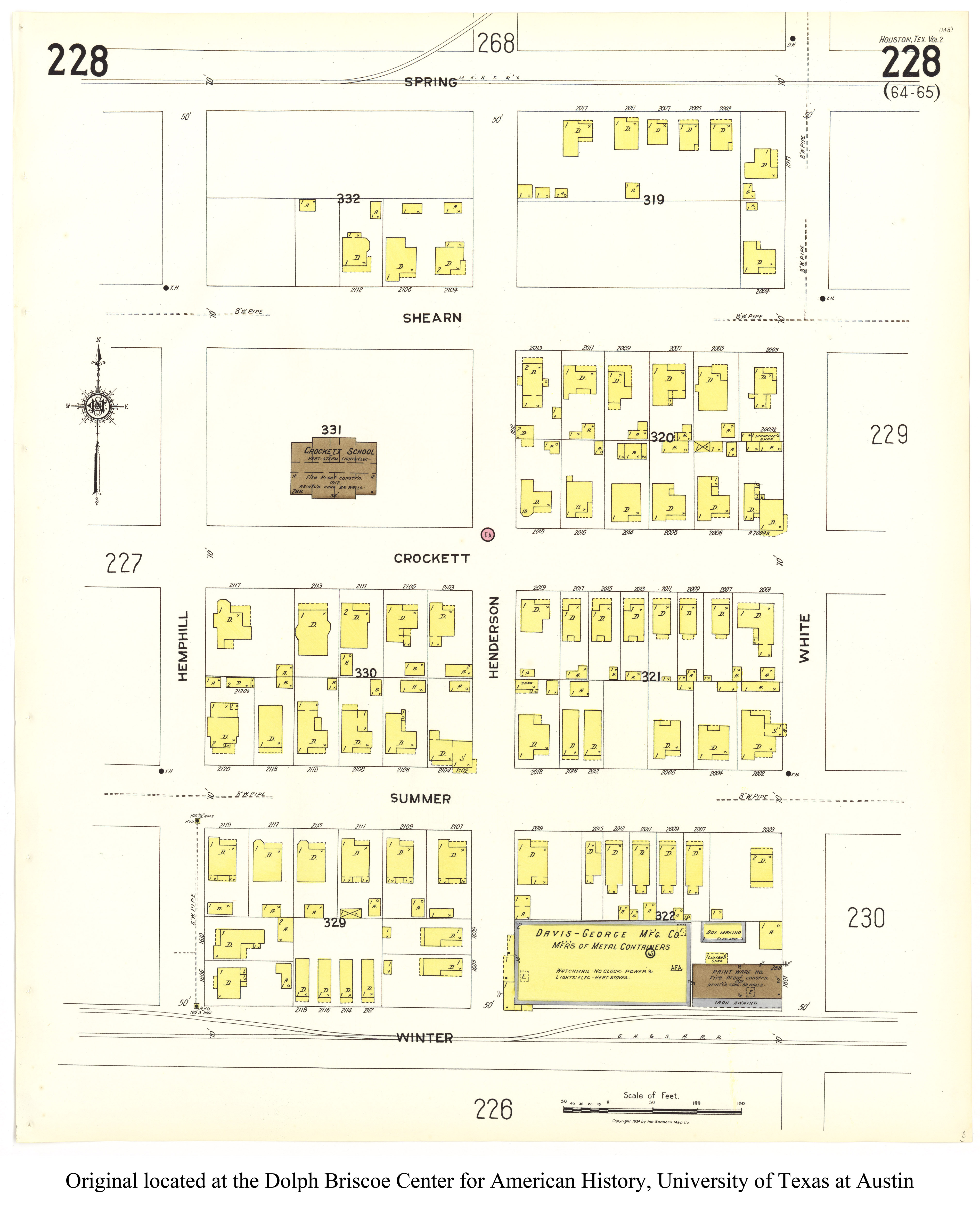
Neither 1809 Hemphill nor 2215 Shearn exist today - the block they are on is now part of Crockett Elementary - but here is where they were located on this composite of two 1924 Sanborn maps (click on the image to make it bigger):


Above: Intersection of Shearn and Hemphill, 1924 Sanborn map composite of portions of http://legacy.lib.utexas.edu/maps/sanborn/g-i/txu-sanborn-houston-1924-vol02-227.jpg and http://legacy.lib.utexas.edu/maps/sanborn/g-i/txu-sanborn-houston-1924-vol02-228.jpg

Below:  Google Map street view of 1809 Hemphill in October 2007.  The back side of 2204 Crockett can be seen in the background - see how the upstairs window matches up with the building to the left in the photo of Ruth and Shakespeare?


You'll note that 1809 Hemphill is marked with an S, indicating a store, on the 1924 Sanborn map.  This address does not appear on the 1907 Sanborn map, and the criss-cross directories indicate it was built sometime between 1920 and 1924.  The 1925 Houston city directory is the first to show a grocer there,  L[ouis] A. Cramer (1869-1933).

The December 1950 Sanborn map for this area (which is still under copyright, so I cannot show an image) shows the building just behind Ruth and Shakespeare, with the garage on the lower level, with an address of 1807 Hemphill.  That address shows up in criss-cross directories for the relevant time period (1935-1942).   Therefore, I feel confident I have the right location for the photo at the beginning of this post.

My mother's former address of 2215 Shearn was declared dangerous in October 1993 and was ordered to be demolished within 30 days.  That had definitely happened by February 2008, as it does not appear in a Google Map street view of that date.  In early October 2009, demolition permits were issued for the old store at 1809 Hickory as well as the three remaining buildings on the 2200 block of Shearn, as well as for the five remaining buildings in the 2200 block of Crockett.  All of this property had been acquired a few years earlier by the Houston Independent School District to expand Crockett Elementary School.

Lydia Ruth Roy was born November 5, 1926, in Detroit, Michigan.  She married Dr. Thomas Robert Scott on December 24, 1952, at St. Mark's Episcopal Church in Houston.  They had a daughter, Alison Louise Scott, who tragically died in a bathtub drowning just short of her first birthday in 1957, and is buried in Columbia, South Carolina.  Ruth died December 5, 2003, and is also buried in that city.


© Amanda Pape - 2019 - e-mail me!

Saturday, October 19, 2019

Happy 91st Birthday to My Mom!

Today my mom, Geraldine Margaret Guokas Pape, turns 91.  Here are a couple of pictures of her from about 1932, when she was four years old.  She is outside the family's then-home of 1717 Shearn in Houston, Texas.   I think in this first photo, she is outside the side of the house that faced Shearn, and the porch behind her had been rebuilt since 1908-1909.


This second photo is looking down the street from outside the house - I think looking west down Shearn, at houses on the north side of the 1700 block.   I believe the house just above her head is 1704 Shearn, built in 1930 (according to the accessor's records) and still standing (and restored!) today.


Both photos are stamped on the back with the number 27 and a logo for Gregg and the saying, "Gregg's Crest Marks the Best."  The 1932 Houston city directory shows (on page 653) a V. Elmo Gregg and Paul E. Gregg operating Gregg & Son, a photo finishing service, at 810-12 Caroline in Houston.


© Amanda Pape - 2019 - e-mail me!

Thursday, May 10, 2018

Those Places Thursday: 1314 Railroad, Houston, Texas - working backwards from 1907

My great-grandfather Charles (Kazimieras) Guokas Sr. (1863-1939) owned a house at 1314 Railroad in Houston, Texas, from about 1895 until his death in 1939.  He left it in his will to his daughters from his first marriage to Stefania Jasilionis (died 1899).  The house is long gone; the railroad is still there, but the actual street (if there ever really was one in this area) is also gone.

I decided to work backward in tracing this house.  An ad I found in The Houston Post in January 1907 gave 1314 Railroad as Charles Guokas' address, and indicated that a new house at 1717 Shearn was for rent.  The Guokas family had moved to the latter address by the time the 1908 Houston city directory was published.

The wooden structures with an address of 1314 (and 1314 and 1/2) on Railroad show up on the 1907 Sanborn maps. The yellow coloring indicates that they are made of wood.  Note that the house falls between what were then Hickory and Oak streets.  Oak was renamed Goliad sometime after 1907 but before 1924.  Also, this section of the map looks about the same on the 1924 Sanborn map, at least as far as 1314 Railroad is concerned.


Sanborn Map Company. Houston 1907 Vol. 2 Sheet 1, map, 1907; New York. (texashistory.unt.edu/ark:/67531/metapth550296/m1/1/: accessed May 6, 2017), University of North Texas Libraries, The Portal to Texas History, texashistory.unt.edu; crediting The Dolph Briscoe Center for American History.


The 1314-and-a-half building is not on the 1896 Sanborn map, but the other two buildings are:


Sanborn Map Company. Houston 1896 Sheet 47, map, 1896; New York. (texashistory.unt.edu/ark:/67531/metapth551114/m1/1/: accessed May 6, 2017), University of North Texas Libraries, The Portal to Texas History, texashistory.unt.edu; crediting The Dolph Briscoe Center for American History.


I found my great-grandfather listed in the 1895 Harris County Precinct 1 tax roll (click the image below to enlarge it).  This gives the legal description of the property:  Baker Addition Lot 2 Block 473, Evans Survey Block O.


"Texas, County Tax Rolls, 1837-1910," database with images, FamilySearch (https://familysearch.org/ark:/61903/3:1:939F-WD9M-W?cc=1827575&wc=M636-7N5%3A161548701%2C161401301 : 21 July 2016), Harris county, Precinct no. 1 > 1895 > image 285 of 317; State Archives, Austin.


There's another reference to a similar legal description in a July 1, 1897, newspaper notice on real estate transfers from the previous day. "Gus Guokus [sic] to Stafania Guokos [sic], 50x100 feet in Sweatman [sic] tract, part of lots 1, 2 and 3, block 473, Baker additon, N. S. B. B., $1."  I believe Gus was supposed to be Chas (a common abbreviation for Charles), and notice that Guokas is spelled two different ways, neither of them correct.  The N. S. B. B. stands for North Side Buffalo Bayou, and 50x100 feet was the common dimension of a lot in this area.  A map further down in this post will show that lots 1, 2, and 3 make up the lot that 1314 Railroad is on in the 1896 and 1907 Sanborn maps.  I'll also explain the part about the (misspelled) Sweetman tract, and the Evans Survey mentioned in the 1895 tax roll.  Given that this transaction only cost a dollar, I believe my great-grandfather was simply putting the property in his wife's name.


The Galveston Daily News. (Galveston, Tex.), Vol. 56, No. 99, Ed. 1 Thursday, July 1, 1897 [Page 3], newspaper, July 1, 1897; Galveston, Texas. (texashistory.unt.edu/ark:/67531/metapth442409/m1/3/?q=%22block+473+baker+addition%22: accessed May 6, 2017), University of North Texas Libraries, The Portal to Texas History, texashistory.unt.edu; crediting Abilene Library Consortium.


The 1890 Sanborn map, pictured below, doesn't show any development in this area (click on the map to enlarge it), the large rough-rectangle north of the railroad, west of the Old Cemetery, south of Dart street, and east of Houston avenue.  I believe my great-grandfather acquired his land in this area in 1895 and built a home there no later than 1896.  Daughter Mary Margaret ("Mamie") was born in February 1895 in Hearne in Robertson County, but I think the family moved to Houston soon after that.  Note in this map, the area is referred to as "Hollingsworth," which was the original name of the survey in this area, done by S. P. Hollingsworth and filed in July 1838.


Sanborn Map Company. Houston [October] 1890 Sheet 1, map, 1890; New York. (texashistory.unt.edu/ark:/67531/metapth551431/m1/1/: accessed May 6, 2017), University of North Texas Libraries, The Portal to Texas History, texashistory.unt.edu; crediting The Dolph Briscoe Center for American History.


Here is the 1885 Sanborn map for the area.  What I like about this map is the block numbers along Dart street - these will be relevant later.  Again, there is no development in the large area bounded by Dart on the north, John on the west, the railroad on the south, and Tenth on the east.  


Sanborn Map Company. Houston [August] 1885 Sheet 1, map, 1885; New York. (texashistory.unt.edu/ark:/67531/metapth550211/m1/1/: accessed May 6, 2017), University of North Texas Libraries, The Portal to Texas History, texashistory.unt.edu; crediting The Dolph Briscoe Center for American History.


The next map comes from the Kosse and Scott map of Houston dated 1867.


Here's an enlargement to the relevant part of the First Ward of Houston (the yellow line on the map, an extension of downtown's Congress Avenue, being the southeast boundary of that ward).  Note the area just above that line and to the left of the blue square City Cemetery:


Here's the relevant part of the map enlarged a little more (click on the image to make it even bigger).  Note the parcel labeled "Swetman," a misspelling of Sweetman.  It is part of this piece of property that became 1314 Railroad.


This area of Houston has a complicated history in the deed records, according to some research done by Kent McMillan, a land surveyor.  He references a map called "Plat Showing the Baker, Shearne [sic] & Riordan Add.[ition]" that is also called Map No. 300-A, in the records of the Houston City Engineering Department and held by the present Houston Department of Public Works and Engineering.  He believes this map was originally created prior to 1857,  because it does not show the Houston & Texas Central Railway tracks on West Street [later Railroad Street] that were reportedly laid in 1856.  The map is not the original; it also has some handwritten notes dating from 1894 and later (for example, Oak becoming Goliad after 1907).  Click on the image below to enlarge the map.


On both the map above and the closeup below, the additions of block numbers in red and the yellow highlighting of three lots are mine.  There appears to be a seam or fold line on the map right where the block numbers would have been; 471 had already been handwritten in to the block to the left of the ones in question.  The numbering is consistent with the sequence used in the area just below, and 473 matches up with the legal descriptions for the property in the 1895 tax roll and 1897 real estate transfer notice.  The three lots highlighted in yellow are the lots 1, 2, and 3 referred to in that 1897 notice.


Apparently sometime between this roughly-1856 map and the 1897 notice, my great-grandfather purchased parts of lots 1 and 3 (he apparently owned lot 2 in 1895) to create a new lot that fronted on Railroad Street.  The standard lot size at the time was 50 feet by 100 feet, and that's about what his new lot was sized (according to the scale on the 1907 Sanborn map).  It's just that now the 100 feet runs north-south instead of east-west.

Here (colored in green) is what I believe to be my great-grandfather's lot on a present-day map, from the Harris County Appraisal District Parcel Finder:


Note that its perimeter measures 50 feet - 100 feet - 51feet - 110.4 feet, because it's not exactly rectangular due to the railroad.  The legal description for this lot is "TR[act] 2 BL[oc]K O EVANS."  The City of Houston has owned it since at least 1988; the area is currently used for a police tow-away compound, and the buildings on it are long gone.

Take a look, below, at the plat (from the Harris County Clerk records online) for a small development at the southwest corner of the intersection of Dart and Hickory (click on the image to make it larger).  Tracts/Lots 5 and 12, just above my great-grandfather's Tract 2 in the map above, are referenced below as "Lot 5 (or 12) Block O Evans (unrecorded").  The development in question is part of Block P Evans.


Here is the legal description on the plat for the development pictured above.  Note that it references the Hollingsworth Survey in the John Austin Two-League Grant, Abstract No. 1, North Side of Buffalo Bayou, as well as the Evans Addition.


Apparently, even though the Evans plat is unrecorded, that seems to be what most of the legal references now use, as opposed to the (also unrecorded) Baker addition.  That might be because Baker's 1856-ish plat subdivided some lands he did not own!

According to McMillan's research,  the relevant land in the Hollingsworth survey was conveyed to Henry Evans in December 1839.  Sometime before February 1866, Evans gave power of attorney to Charles Shearn, who in turn conveyed a tract to T. W. Sweetman that was described in the deed  (Book 2 Page 365 Harris County Deed Records) as “including Lots Nos. 1, 2, & 3 in Block 473 as shown by W.R. Baker’s Map.”

So somewhere this land picked up the designation as the "Evans Addition," with blocks "numbered" with alphabet letters.  I'd love to find that map, as well as one with the block numbers for the Hollingsworth Survey.  Note that while the description above mentions that survey and some lot numbers, no block number is given.

Nevertheless, I'm confident that I've identified the "right" piece of property that was in the Guokas family from at least 1895 through at least 1939.


© Amanda Pape - 2018 - click here to e-mail me.

Sunday, March 11, 2018

Church Record Sunday: Sacramental Records for Roy Lee Guokas

Recently I stumbled across some unindexed records at FamilySearch.org for Catholic churches my mother and her ancestors were parishoners of in Houston, Texas.  Using some indexes built into the documents, as well as some paging to appropriate dates, I found records for a number of relatives.

Here are the sacramental records for my great uncle, Roy Lee Guokas III (1917-1959), all at at St. Joseph Catholic Church, Houston, Texas:


Above:  Baptism record - Roy Lee Guokas is on the last line.  He was born on July 5, 1917, and baptized one month later, on August 5, 1917.  The godparents appear to be Mrs. H. Snider and Stanley Biechi.  There's also a note that Roy married Maxine Hooks on June 21, 1942, at St. Joseph in Houston.

Below:  First Communion record, on May 9, 1926.  Roy's date of birth is also shown.


Above left:  Roy Lee Guokas (far right) with his sister-in-law Sara Melzina Wolfe Guokas Archibald (1907-1997) and his nephew Charles Guokas III (1927-1999), probably in early 1928 and probably at 1717 Shearn, Houston, Texas, where Roy Lee was living at the time.

Above right:  Roy Lee Guokas (far right) with his brother Charles Peter Guokas Jr. (1903-1967) and his nieces Geraldine Margaret Guokas Pape and Jo Ann Guokas.  Easter, probably about 1933, in Houston, Texas.


Above: Confirmation record for Roy Guokas, May 12, 1929 - he is third on the list.  His confirmation name - like that of all the other boys - is Joseph.

Below:  Marriage record for Roy Lee Guokas and Maxine Hooks, on June 21, 1942.  Note that there is no record of baptism for Maxine, and that they are already living at the same address.  Under the annotations (which include dispensations) to the right there is a note that says "revalidatis," which indicates that a non-Catholic marriage ceremony had already occurred.  (There are other notes indicating "mixtae [mixed] rel[igion]" and "disp[arity of] cult ad cautelam." This is in the case of a doubtful baptism, when a person says he/she is baptized, but can produce no certifcate proving the claim.)  A little more searching turned up a marriage license and return in adjacent Fort Bend County, Texas, for a marriage between Roy and Maxine on June 21, 1937.


This record was particularly valuable to me because I had the wrong maiden name for Maxine.  The 1940 Census had Maxine's younger sister living with the couple, and listed her last name as Cook, not Hooks (she was 16 and single).  I was able to trace Maxine particularly with her parents' names listed on the church record:  Henry C. Hooks and Lucy Lee.  The record also spells my elusive Lithuanian maternal great-grandmother's name as Bonewitch, more evidence for that phonetic pronunciation.  The witnesses to the church ceremony were what looks like Mrs. Elizabeth Gouldg and George some-initial Rabroke - neither of those names are familiar, and they could just be other people in the rectory at the time this record was made.


The picture above is of most of the surviving full siblings of my maternal grandfather Charles Peter Guokas Jr. (1903-1967), taken around late 1942 in Houston, Texas. Youngest brother Roy Lee Guokas (1917-1959) is at the far left. He enlisted as a private in the Army Air Corps on September 28, 1942, and was sent to Australia to work in supplies, so this was probably taken before he shipped out.

The others in the photo, moving to the right from Roy, are Philip Edgar Sayers Sr. (1901-1972), next to his wife Elizabeth "Lizzie" Wanda Guokas Johnson Sayers (1901-1980).  Next to her are my grandparents, Charles Guokas Jr. and Sara Melzina Wolfe Guokas Archibald (1908-1997).  The next woman is Roy's wife at the time, Maxine LaVerne Hooks Guokas Huett DeMarco (1919-2012), followed by Eva Louise Guokas Scott (1907-1979) and her husband, Otis Henry Scott (1901-1990).

The photograph was taken at Lizzie and Philip's home at 810 Avenue of Oaks in Houston.  Sister Agnes "Aggie" Verna Guokas Payne (1905-1974) and her husband Milton Clyde "Jack" Payne (1904-1991) are not in the picture, even though they were still living in Houston at the time.

Roy and Maxine were married through at least 1942.  In May 1948, Maxine married her second husband, and by the time of publication of the 1951 Houston city directory, Roy's wife is listed as Fay - Fay Lois Florence Boulter Guokas Nelson (1922-2005), the mother of his daughter Gloria Guokas Ahmad Stone (1941-2017).  Gloria had five children.

Sometime between 1953 and 1958, Roy and his family moved to California, where Roy died on February 19, 1959, in Los Angeles County, at only age 41.  He is buried at South Park Cemetery in Pearland, Brazoria County, Texas.


© Amanda Pape - 2018 - click here to e-mail me.

Thursday, September 19, 2013

Those Places Thursday: 1717 Shearn, Houston, Texas, circa 1908-09

This house, originally at 1717 Shearn in Houston, Texas, was the one where my mother, Geraldine Guokas Pape, spent her early years.

The house was originally owned by her grandfather, Charles Peter Guokas Sr. (1863-1939), starting in 1908-09.  That is the year the family is first listed in the Houston city directory at this address.  Previously, from 1899 through 1907, the family was listed as living at 1314 Railroad.

I believe this photograph was taken shortly after the family moved into the house.  In the enlargement below, you can clearly see 1717 above the door in two places.  My great-grandmother Elizabeth (ElÅŸbieta) Banaitis (Banaitytė) Guokas (1875-1929) is standing in the doorway.


The three children are my grandfather, Charles Peter Guokas Jr. (1903-1967), and his younger sisters Eva (1907-1979) and Agnes "Aggie" Verna (1905-1974).

There's a tree that's been planted just in front, visible between the two little girls.

On the 1930 Census, my great-grandfather was still living in this house, along with his youngest son Roy Lee Guokas (1917-1959), my grandfather, my grandmother Sara Melzina Wolfe Guokas Archibald (1907-1997), and my one-year-old mother and her older brother, Charles Guokas III (1927-1999).

My mother's family lived in this house until June 1933, when they moved to Austin when my grandfather was appointed secretary to Governor Miriam Amanda Ferguson.  My great-grandfather continued to live in the house until his death in April, 1939.  The house was left to Roy who lived there until at least 1948. 

I drove by this address in April 2012, only to discover the house had been torn down, apparently (according to Google Maps) by July 2011.  The property (Lot 12, Block 299, Baker Addition) and the adjacent lot have recently been subdivided into single-family townhome lots for construction of three-story (plus rooftop terrace), three-bedroom, 3.5 bath homes selling for about $395,000.

ETA 23 April 2018 - My great-grandfather apparently built the house in late 1906.  Here is an ad I found in The Houston Post of January 22, 1907, indicating the new house at 1717 Shearn was for rent:


The Houston Post
. (Houston, Tex.), Vol. 22, Ed. 1 Tuesday, January 22, 1907, newspaper, January 22, 1907; Houston, Texas. (texashistory.unt.edu/ark:/67531/metapth603226/m1/10/?q=%221314+railroad%22: accessed May 5, 2018), University of North Texas Libraries, The Portal to Texas History, texashistory.unt.edu; .


ETA 20 October 2019 - Some research in the deed records shows that 1717 Shearn (aka 1814 Sabine, as the length of the house faced that street and had a door, and one apartment in the building likely had that address) was declared substandard in July 1997, and repair or removal was ordered.  By August 2009, it had decayed to the point of being dangerous, and demolition was ordered within 30 days.  In late June 2011, the city issued an emergency order to demolish within 90 days.  However, Google Maps street view photos from April 2011 show a big pile of rubble on the site and at the curb.  So the demolition likely occurred sometime between August 2009 and April 2011.

I also found Sanborn maps of the area.  In 1907 (see below), there was a dwelling at the corner of Shearn and Sabine with the address 1719 Shearn, and there was a two-story bakery next door to 1717, at 1715 Shearn, with a tile oven in the corner of the lot:


By 1924 (see above), the structure at 1719 is gone, and 1715 is defined as a two-story flat, with no oven on the lot.  By December 1950 (still under copyright, so I can't use an image), both 1715 and 1717 Shearn have the same footprints, but are shown as apartment buildings.


© Amanda Pape - 2013 - click here to e-mail me.

Sunday, September 15, 2013

Sentimental Sunday: Charles Guokas Jr. & Members of the Interurban Buffet Baseball Team, Houston, Texas, about 1920*

The young man not in a baseball uniform kneeling at left in the photo at left is my maternal grandfather, Charles Peter Guokas Jr. (1903-1967).  His older cousin Adam Lawrence Guokas (1901-1966), played baseball for a local team, but I'm not sure if he is in this photo.  Not until I scanned and enlarged it did I notice the young man on the ground, peering between the legs of the other team members!

My grandfather looks to be around 20 at most in this photo, so I believe it was taken in the early 1920s.

Based on the letters on the jerseys, I think the team is sponsored by Interurban Buffet.  Sure enough, there was such an institution in Houston, at least from 1921 through 1931, according to these ads and news stories I found.

The Interurban Buffet was located at 1001 Texas Avenue at Main Street in downtown Houston.

Above and below: Ads from the Rice University Thresher - April 8, 1921, page 6 (above) and April 22, 1921, page 3 (below), both via the Portal to Texas History.


from Galveston [TX] Daily News, December 23, 1931,
page 6, via NewspaperArchive.com


This was the location of the Binz & Settegast Building, Houston's first "skyscraper," a six-story building across the street from the Rice Hotel.  It was constructed in 1898.  Today, it doesn't look anything like the picture below and in the ad linked to above, as it was completely rebuilt in 1982.

(ca. 1900). Texas Avenue corner view from Fannin Street.
Historic Houston Photographs. Special Collections,
University of Houston Libraries. Retrieved from
http://digital.lib.uh.edu/collection/p15195coll2/item/190


copyright © Amanda Pape - 2013 - click here to e-mail me.

[*ETA on March 19, 2015:  I found a reference to an article in the March 23, 1920, Houston Post, on page 13, about a game the team played:  "BUFFET BEATS SUNSET. The Interurban Buffet team defeated the Sunset Heights team on the Sunset diamond Sunday by the score of 17 to 0. The batting of the Buffet team was the feature of the game....The Buffet team is open for games with any team in Texas. For games, address B. Anderson, 2005 Hickory."]

Wednesday, May 22, 2013

Wordless Wednesday: Charles Peter Guokas Jr., ABT 1915


My maternal grandfather, Charles Peter Guokas Jr. (1903-1997), pictured with the family cow outside their home at 1717 Shearn in Houston, Texas.  He looks to be about 12 here, so I think this is about 1915.  I believe this view is looking south, towards the house behind them at 1720 Crockett.  That house was a one-story dwelling, according to Sanborn maps from 1907 and 1924.  The roofs of houses to the west along Sabine street (1717 Shearn was at the southeast corner of Shearn and Sabine) can be seen on the right.


© Amanda Pape - 2013 - click here to e-mail me.

Friday, May 17, 2013

Friday's Faces from the Past: Agnes Verna Guokas, circa 1910

This is my great aunt Agnes "Aggie" Verna Guokas Payne (1905-1974) on a donkey, probably around 1910, and probably near the Guokas family home at 1717 Shearn in Houston, Texas.

Aggie was born October 11, 1905, perhaps at 1314 Railroad in Houston, which was the Guokas family address through 1907.  She is the fourth child born to my great-grandmother, Elizabeth (ElÅŸbieta) Banevich (BenevičiÅ«tė, 1875–1929).

In the 1920-21 Morrison & Fourmy Houston City Directory, on page 686, 15-year-old Aggie is listed as a student at Massey Business College. By 1925, Aggie is married.  In the 1925 Houston city directory, she and her husband, Milton Clyde "Jack" Payne (1904-1991) are rooming at 2215 Shearn, also owned by Aggie's father, my great-grandfather Charles Peter Guokas Sr. (1863-1939).

By 1929, Aggie and Jack are living in their own home at 2215 Quenby in Houston, where they will live for at least the next 13 years.  In the 1929 city directory, Aggie is a stenographer for J. C. Leonard, a bond and mortgage company, and she continues in this job through at least 1935.

In 1937, Aggie and Jack's only child, daughter Laura Lee, is born.  Also at this time, they own a piece of property out near Alief, Texas, where they keep a horse

Aggie and Jack are in the 1951 Houston city directory living at 105 N. Haywood Dr., but sometime between then and 1958, they were divorced.  My mother thinks this happened before my parents married in 1954, as she remembers Aggie hosting a shower for her.  The 1958 Houston city directory shows Jack still living on Haywood, while Aggie has a separate listing at 3103 Roe Dr.  She is office manager for Continental Trailways Bus System.  An article in the Daily Court Review from February, 19, 1953, shows Aggie obtained this piece of property (Lot 38, Block 3, Roe subdivision) via a deed of trust on January 30, 1953, so perhaps the divorce occurred around then.

My mother says Laura Lee was interested in competitive swimming, so sometime in the late 1950s (apparently after 1958), Aggie and Laura Lee moved to California.  Aggie lived the rest of her life in San Pedro, and died there on July 28, 1974.  According to my mother, she is buried in Houston.  She had a double plot at a cemetery and her brother Roy Lee Guokas (1917-1959) is also buried there.

© Amanda Pape - 2013 - click here to e-mail me.

Sunday, March 31, 2013

Sentimental Sunday: Easter, ABT 1931

This is my mother, Geraldine Margaret Guokas Pape (at far right), with her older brother, Charles Peter Guokas III (1927-1999, at far left), and younger sister Jo Ann (now Sister Jean Marie, the baby in the middle).  They all have Easter baskets, and I'm guessing the photo was taken around 1931, near their home at 1717 Shearn in Houston, Texas.  Easter fell on April 5 that year.

© Amanda Pape - 2013 - click here to e-mail me.

Wednesday, October 24, 2012

(Not-So-) Wordless Wednesday: Elizabeth Benevičiūtė Guokas and Cow

This is my maternal great-grandmother, Elizabeth (ElÅŸbieta BenevičiÅ«tė) Banevich Guokas (1875-1929).  We're not sure exactly when the photograph was taken, but my mother says the house in the background is their home at 1717 Shearn in Houston, Texas, so it was probably taken sometime between 1908 (when the Guokas family is first recorded living at this address) and 1929, when Elizabeth passed away.

© Amanda Pape - 2012 - click here to e-mail me.

Saturday, April 28, 2012

First Ward Cubs, Houston, Texas, 1922-1923


Two interesting pictures in my mother's collection are from a football team her father, my grandfather, Charles Peter Guokas Jr. (1903-1967, pictured above), was a member of around 1922 and 1923.  The name of the team (below) was First Ward Cubs.  We didn't know much about the pictures beyond that.


The week before last, I was in Houston for the Texas Library Association annual conference, and I used that opportunity to do some research at the Houston Public Library, specifically at the Clayton Library for Genealogical Research, and the Houston Metropolitan Research Center.  One of the databases the library subscribes to (that you can only access with a library card, within the library) is the Access NewspaperARCHIVE.  I've encountered this database before in Internet searches, but it requires a fee to use, so I was excited to find it in the library.  I entered the last name Guokas and turned up over 50 articles!

Three of the articles were from the 1923 Galveston [TX] Daily News, December 1, 2, and 8.  The articles talk about a game between the Galveston Hurricanes and Houston's First Ward Cubs, "who claim the 145 pound amateur championship of Houston." The "Cubs at all times, win or lose, play a clean game of football, never having been cautioned by the referee as to unnecessary roughness, etc."

"The Cub football team is composed of young men between the ages of 16 and 20 years.  All of them are well known in Houston amateur sports."  Apparently their record going into this game was 2-2-1, where "the games the Cubs lost were won by much heavier teams."  They had "a large following of loyal rooters and supporters."

My mother and I were amused to see that her father/my grandfather, who played left halfback, was known as "Goat" Guokas on this team.  He was described as "a good broken field runner and once he gets by the secondary defense it takes a fast man to overtake him."  He and the rest of the backfield "appeared on the local gridiron before and showed speed and driving power" and "are a hard combination to beat at their own weight."

I also thought it was quite interesting that the team practiced at night, probably because the men all had jobs or school during the day.  "The ball has a coating of white calcimine, which enables the back field men to handle the ball with ease on moonless nights."  I didn't find an article that indicated who won this game.

I turned up one more article of interest in the same newspaper (at right), from the May 2, 1921 edition.  It refers to a baseball game between the Alvin [TX] Jasmine Buds and the "Patterson & Crawford Nine" of Houston.  Patterson & Crawford was apparently a company that, in 1922, had a location on Main Street in Houston "handling Diamond and Goodrich tires and tubes," according to page 748 of Automobile Topics, Volume 67.  A Guokas was apparently a catcher for the team, although this could also have been my grandfather's first cousin, Adam Lawrence Guokas (1901-1966).


© Amanda Pape - 2012 - click here to e-mail me.