A couple days ago, I wrote about the location of the 317.92 acres in Winn Parish, Louisiana, where my great-great-great-grandfather, Jacob Shelton settled in 1859-1860. Today, I'm writing about the land of my other great-great-great grandfather, Levi Spikes (ABT 1805 - BET 1880-1900).
A search at the United States Department of the Interior's Bureau of Land Management (BLM), General Land Office (GLO) Records Automation web site for Spikes in Winn Parish, Louisiana, brought up four results: two for Levi Spikes, and one each for his son William H. Spikes (1832-1917) and Levi M[arion] Spikes (1867-1933). I'll get to them in a bit.
When I selected the two for Levi (each 39.57 acres, filed about two months apart in 1860), I got a page for each that provided details about the patents, with tabs to view the actual patent document image, as well as other documents (other patentees within the same land sections as Levi had). On the patent details page, you could scroll down and use a mapping tool (checking the boxes in the Map column) to see just where Levi's land was located (click on the images to view them larger):
These two parcels are next to each other. I went to the State of Louisiana's Division of Administration Office of State Lands GIS & Data web page, and used the SONRIS Interactive Map linked there to create a combined image. I chose "Maps Historic 62.5k" as my background Imagery and used the Draw tool in the AOI Toolbox to draw lines on the map to roughly outline Levi Spike's patents. The result is the lighter green area below (click on the image to view it larger):
The background map, as discovered in my previous posts by exploring the United States Geological Survey's Historical Topographic Map Collection using a tool called topoView, was the 1950 Winnfield, Louisiana topo map, with a scale of 1:62500.
I grabbed a screenshot of the satellite image of this area from Google Maps, and used Microsoft Paint to outline Levi's land. The result is below (click on the image to view it larger):
There's clearly been some settlement on the land, at least since 1950. That did not appear to be the case on the oldest map I was able to find (so far), the United States Department of Agriculture Bureau of Soils 1907 Winn Parish Soil Map, digitized by the University of Alabama. I zoomed in to the appropriate sections, grabbed a screenshot and used Microsoft Paint to outline Levi's land, as well as that of his two sons. The result is below (click on the image to view it larger):
I noticed there are no small black squares (which mark buildings, such as houses) within the Spikes properties. This 1907 map indicates some old roads and old communities that don't exist any more, such as Whitford and New Atlanta. It's possible that Levi and William, who were not required to live on their land as they acquired it though cash purchases, perhaps lived in one of these communities. By 1880, Levi and son William had both moved to adjacent Grant Parish.
Son Levi M. Spikes moved back to Winn Parish (from his father's home in Grant Parish) by 1894, and under the Homestead Act with which he acquired his land, would have had to live on and cultivate the land for five years before patenting it in 1905. Perhaps the 1907 map just doesn't include any structures he may have built there.
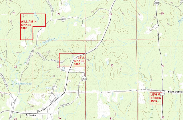
I also mapped the properties on the 2020 Atlanta, Louisiana topographic map, with a scale of 1:24000, to see roads and features as they appear in more modern time. The result is below (click on the image to view it larger):


No comments:
Post a Comment