Pages

Thursday, October 24, 2024

An Old Well on the Granbury Courthouse Square

Earlier this week, I got a sneak peek at the new location of local/my favorite restaurant, Christina's American Table, which will be on the first floor of the recently-restored historic Nutt House Hotel.  In the men's room, there is a window in the floor with a view of an old well (see the photo below).


Above:  View through a window in the floor of the men's room of the old well underneath the Nutt House Hotel and Christina's American Table.

Below:  A wider view of the men's room and the "window to the well."


Apparently, one of the stone pier-and-beam supports when this stone building was constructed (sometime between March 1893 and July 1898) was placed right over the old well opening, and the well was rediscovered in the recent renovation.  So of course I immediately wondered if the well showed up in any old Sanborn fire insurance maps.

Well, it is not specifically marked on any of the available maps.  However, I have a guess on where it was located.  First, look at this map from July 1898.  The building is on the northwest corner of the intersection of Bridge and Crockett. It first appears, in its present stone (indicated by the blue coloring) form, on the July 1898 Sanborn map. Note the location of the wooden posts down the middle of the building (where the red arrow is pointing - click on the image of the map to enlarge it).  They are still there, and this well is to the west (left on the map) of them.


Above:  excerpt of the July 1898 Sanborn fire insurance map for the building that is now the Nutt House Hotel and Christina's American Table in Granbury, Texas -  https://maps.lib.utexas.edu/maps/sanborn/g-i/txu-sanborn-granbury-1898-2.jpg

Below:  excerpt of the March 1893 Sanborn fire insurance map for the site of the building that is now the Nutt House Hotel and Christina's American Table in Granbury, Texas - https://maps.lib.utexas.edu/maps/sanborn/g-i/txu-sanborn-granbury-1893-1.jpg


The building in present form (see the photo below) was constructed sometime between March 1893 (based on the Sanborn map above) and July 1898. Its predecessor was two wood frame (indicated by the yellow coloring) buildings. Note that the one on the left does not extend as deeply into the lot as the one on the right. Although no well is indicated on this map, the well could have been constructed after March 1893, and then the stone building of today built over it.


Above:  Nutt House Hotel on March 2, 2023, after the March 1, 2023 fire that nearly destroyed it when its restoration was nearly complete.

Below:  Nutt House Hotel on October 24, 2024, about to reopen, with Christina's American Table on the first floor.


© Amanda Pape - 2024 - e-mail me!

Tuesday, October 22, 2024

Success in a Remote Cemetery in Oklahoma

On the way home from visiting my late husband's first cousin in Oklahoma City last Friday, I went almost to the state of Oklahoma's eastern border with Arkansas, in search of the Vaughn Memorial Cemetery in Le Flore County, near the community of Gilmore, which is east of Poteau and north of Monroe.

As I wrote in an earlier post, I found my husband's great-grandfather, John L. Gresham, listed in a 1937 inventory for this cemetery.  I made a photo request through FindAGrave, but it hadn't been fulfilled in some time, which made me think that perhaps the grave marker didn't exist any more.

Well, it's there.  Here's a photo of the top of the marker, which has toppled from its base and now lies flat on the ground.  It reads:
J. L. Gresham
Born Feb. 1, 1855
Died Feb. 15, 1892


Above:  Photo of the top of the grave marker for J[ohn] L Gresham, showing the inscription.  Click on the image to view it larger.

Below:  The sign for the Vaughn Memorial Cemetery on Le Flore County Road N4780 (also known as the Gilmore Road), near Poteau, Oklahoma.  The red arrow points to the toppled grave marker for John L. Gresham (which I also marked for this photo by placing a water bottle on it.  Click on the image to view it larger.


Amazingly, between my GPS, a map on my phone, and notes about mileages and turns, I didn't get lost finding this (but I did learn that there are NO rest stops with restrooms on Interstate 50 between Oklahoma City and Sallisaw, near the Arkansas border).  My strategy upon arrival was to search near the cemetery sign pictured above, which was next to the road.  The older graves appeared to be in this area, and it made sense to me that burials would have started closer to the road.  This turned out to be a good strategy, because as you can see from the red arrow, John's grave WAS close to the front.

What I noticed first was the footstone, pictured below, which was propped up against the base of a toppled monument.  "J. L. G." - John L. Gresham - this had to be it!


Above:  Footstone for the grave of J[ohn] L G[resham], leaning against the base of a toppled monument

Below:  Looking over the base to the toppled monument.


I was amazed to see that the front of the monument was quite detailed!  (Click on the image below to enlarge.)  Although somewhat worn from the weather, there is clearly a flying dove carrying a banner that reads "At Rest" flying under an arched roof made by multiple columns leading into some sort of room with a tiled floor. At the bottom of the front of the monument, these words are engraved: "Resting in hope of a glorious resurrection."


Above:  the detailed front of the grave marker for John L. Gresham

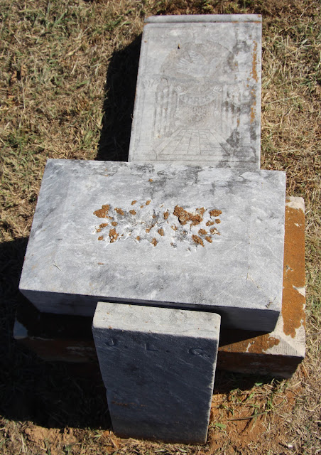
Below:  Looking at the toppled monument from the top down - the inscription with the name and dates of birth and death is upside down at the bottom of the photograph.


I was thrilled to find this, and I've updated John L. Gresham's FindAGrave memorial with these images.  

I also visited the nearby Monroe Cemetery (just 3.4 miles due south), where my husband's great-great-grandmother Mary Malissa Hallmark Self is buried (along with one of her grandsons).  I did not find her husband, Vincent Garner Self Jr., there, nor did I find their daughter, John L. Gresham's wife (and my husband's great-grandmother) Lucinda "Lulu" Vina Self Gresham Young, in the Oak Hill (aka Kiowa City) Cemetery in the town of Kiowa in Pittsburgh County, 89.4 miles southwest.  It's possible they never had markers, the markers are long gone, or the newspaper accounts of their deaths were incorrect about the burial places.


© Amanda Pape - 2024 - e-mail me!

Saturday, October 19, 2024

Mom Would Have Been 96 Today


Geraldine Margaret Guokas Pape (1928-2019), about 1952, Houston, Texas.  
She is wearing a hat with a face veil, popular at that time.


© Amanda Pape - 2024 - e-mail me!